Upper Peninsula of Michigan Snowfall Totals
Winter 2024-2025
Good day to you friend, winter is here again in the Upper Peninsula, are you ready for another snowy and cold winter? Snowfall is a big part of life in the Upper Peninsula and very memorable, we Yoopers love to talk about how much snow we get each winter. This is the 15th year of snowfall reports on FunintheUP.com, thanks for following the snowfall page!
Thousands of people follow from all 50 states and people from all over the world follow FunintheUP Snowfall Reports all winter. The snowfall totals are used by snowmobilers, news stations, emergency personnel, city officials, road crews, skiers, snowboarders, groomers, ski resorts. The most snow for 2023/24 was at the Calumet Tamarack loation snow station with 173 inches of snow you can view last years snow totals here. Begin looking at the 2024/25 winter season snowfall totals below along with other snowfall data and info.
--Thank you so much for your support for over the years, Yooper Steve.
Whose woods these are I think I know. His house is in the village though. He will not see me stopping here. To watch his woods fill up with snow.
-- Robert Frost (1874-1963)
Previous Years Snowfall Totals
2023/2024 Upper Peninsula Snowfall - 2022/2023 Upper Peninsula Snowfall2021/2022 Upper Peninsula Snowfall - 2019/2020 Upper Peninsula Snowfall - 2018/2019 Upper Peninsula Snowfall
2017/2018 Upper Peninsula Snowfall - 2016/2017 Upper Peninsula Snowfall - 2014/15 Upper Peninsula Snowfall
Top 5 snowfall amounts in the Upper Peninsula.
390.4" - 1978/79 - Keweenaw county (near Delaware)
384.0" - 1996/97 - Herman
367.4" - 1995/96 - Keweenaw county (near Delaware)
362.8" - 2018/19 - Tamarack location (near Calumet)
354.1" - 1978/79 - Houghton county airport
384.0" - 1996/97 - Herman
367.4" - 1995/96 - Keweenaw county (near Delaware)
354.1" - 1978/79 - Houghton county airport
Thank you so much for your support! -- Yooper Steve I'll be doing snow updates all winter on Facebook, Instagram, TikTok, and Youtube so be sure to follow and subscribe on those socials if you aren't already.
Snow totals are updated on the website through Feb 11th and Subscribers of the Yooper Report will be emailed the Feb 15th and 16th Snow totals 2.17 later in the night.
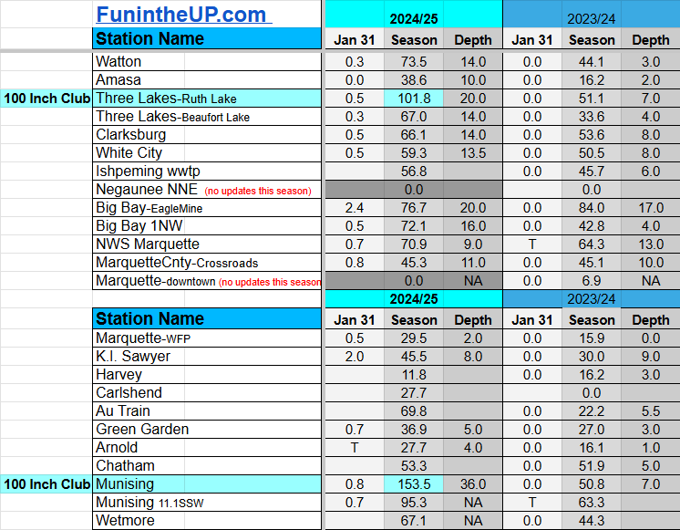
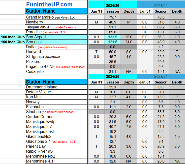
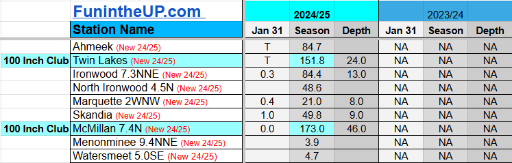
Snowfall on Jan 31, 2025
Snowfall Reports by Yooper Steve
Daily UP Snowfall for 2024/25
Today's Notes:
This post first posted on the Yooper Report - FunintheUP Substack, it is an email newsletter that is sent out to subscribers.
Paid subscriptions on Substack allow these snowfall reports and fall color reports to continue each year. Thanks for subscribing to the Yooper Report become a subscriber to get snow totals and snowfall report/forecast emailed to you before they post here on the website.
Check out the FunintheUP Amazon Store - my recommended camping gear, winter clothing, Yooper rock hunting stuff, U.P. books worth reading
Join me on a Guided U.P. Tour to see places you’d never see on your own - UpperPeninsulaTours.com - adventures away from the crowds
Most snowfall Jan 31: Big Bay (EagleMine) with 2.4 inches
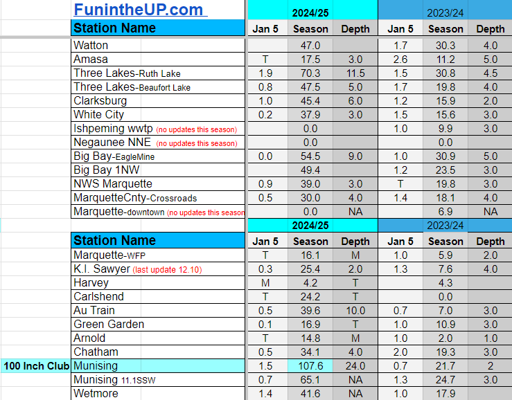
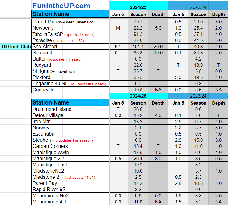
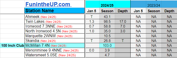
Most snowfall, season to date: Painesdale with 188.9 inches
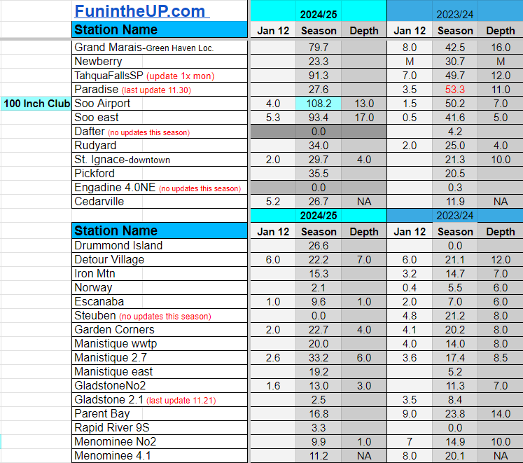
Biggest 24hr total this season: Soo Airport with 15.7 inches (11.30.24)
If daily slot is 0" the station hasn't updated or recorded no snowfall.
Sometimes a station won't update that day and does the next day.
Tahquamenon Falls State Park only updates at the end of each month.
Keweenaw county and Houghton County Airport only update during the weekdays.
Sanderson Field Airport (Soo) updates next day.
Jan 31
NOTE: Hover cursor over images to enlarge snowfall totals.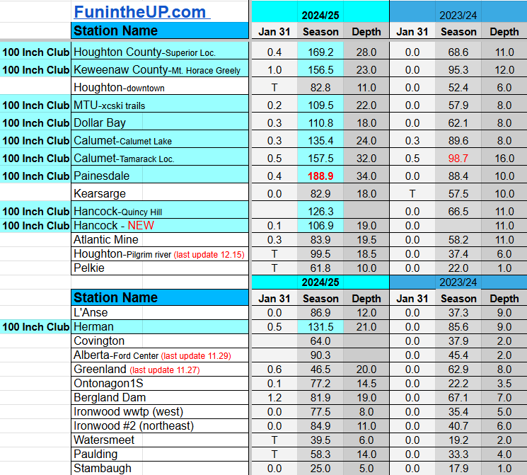
Do you enjoy FunintheUP videos and seeing the Snowfall Totals all winter? Consider supporting FunintheUP via PayPal - via Venmo
Thanks for following the U.P. Snow Totals page on FunintheUP.com
FunintheUP Youtube channel TourDaYoop Youtube channel FunintheUP on TikTok Yooper Steve on Facebook
Yooper Steve on Instagram
FunintheUP on Instagram
Snowfall on Jan 28/29, 2025
Snowfall Reports by Yooper Steve
Daily UP Snowfall for 2024/25
Today's Notes:
This post first posted on the Yooper Report - FunintheUP Substack, it is an email newsletter that is sent out to subscribers.
Snowfall has been pretty light over the last week but the winds were really whipping the last few days, even with the warmer temps it still felt cold. Today we saw temperatures reaching into the low to mid 30s along with a nice day of sunshine. It is always nice to have a few days each month during the winter where we see a full day of sunshine and slightly warmer temps, it just brings up your spirits and puts smiles on peoples faces.
The temperatures look to be up and down for the next 7 day, warmest day looks to be Sunday, reaching back into the 30s again. with wind gusts reaching into the 40mph range again late Sunday night. Most days through the next 7 days there is a slight chance of snow nothing more than a couple inches at a time, but Sunday may yield 2-4 inches across the Keweenaw. It is nice to see a few fresh inches of snow every few days to keep the xc ski trails and snowmobile trails fresh.
Snow has been a plenty in places like Munising, Newberry, and the Soo. Those areas are seeing a higher than normal snowfall year. Places like the Keweenaw are seeing about normal to slightly lower than normal, and out in the western UP near Bergland and Ironwood, slightly lower than normal snowfall. There is a lot of winter yet, we still have our coldest part of the year arriving the next couple weeks into early March and we all know we can see some big snow events in March and sometimes see some decent snowfalls in April.
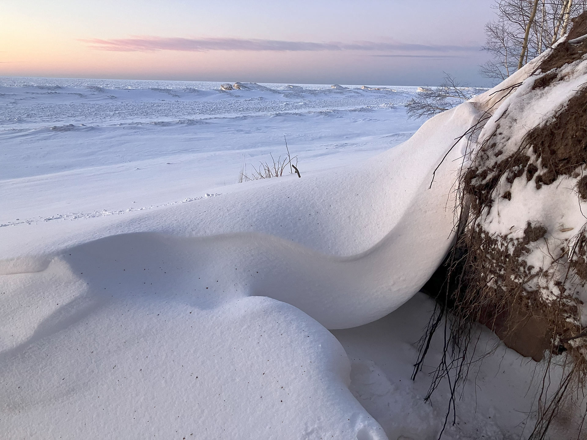
I took a ride out to Agate Beach today to watch the end of the sunset with clear skies, it was orange and yellow, very nice after many days of dark and gloominess.
I walked out onto the ice and explored some ice mounds and enjoyed the last little bit of light for the day. It was really peaceful and quiet out there but I could hear the ice shifting and cracking out from where I stopped at on some ice mounds.
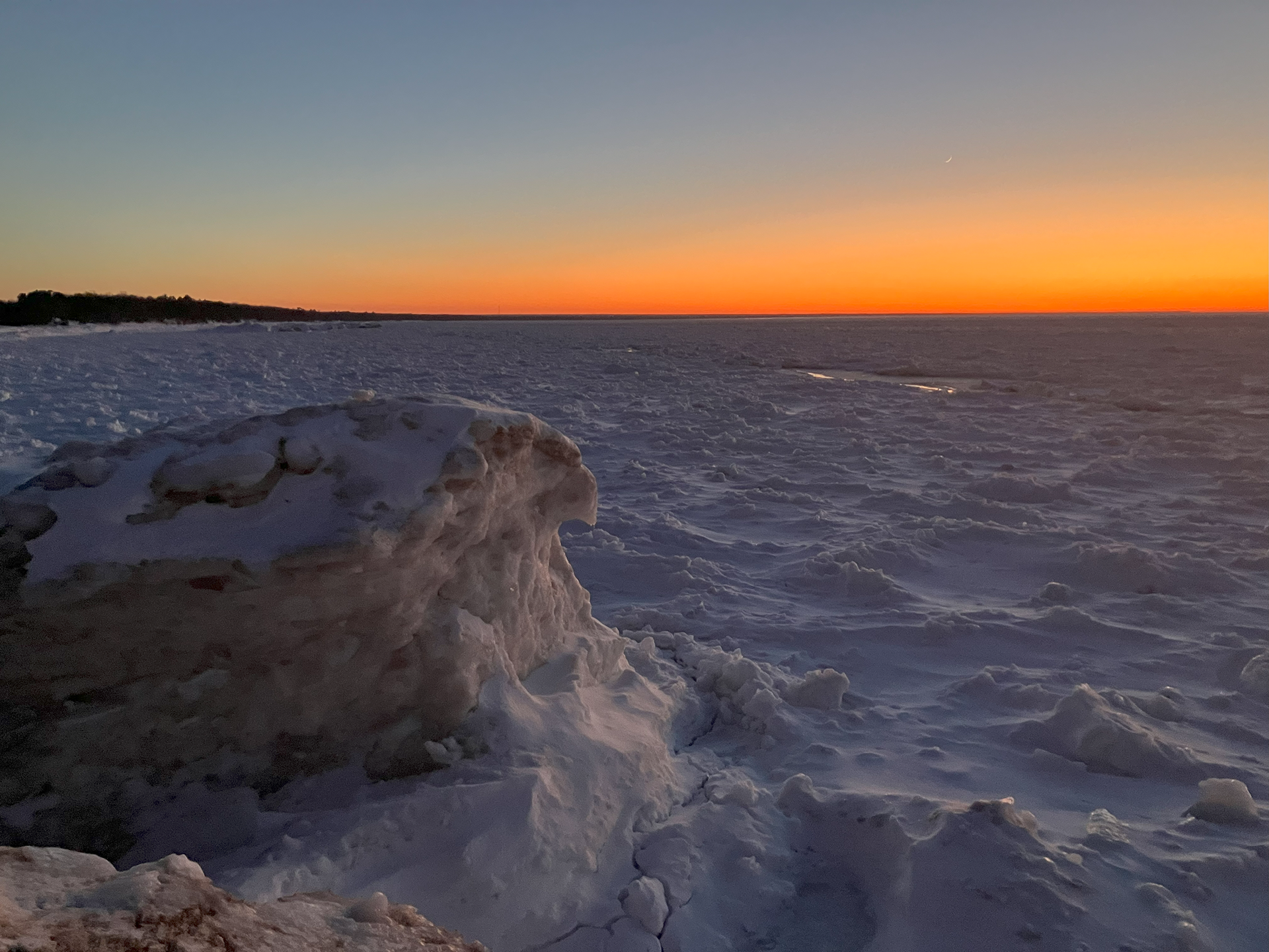
I don’t recommend going on the ice at anytime, don’t follow what I do. You have to treat all ice as unsafe at all times, I have been exploring the lakeshore ice mounds, ice caves, and ice volcanoes all my life and have lots of experience, but even with that it can still be dangerous.
Paid subscriptions on Substack allow these snowfall reports and fall color reports to continue each year. Thanks for subscribing to the Yooper Report become a subscriber to get snow totals and snowfall report/forecast emailed to you before they post here on the website.
Check out the FunintheUP Amazon Store - my recommended camping gear, winter clothing, Yooper rock hunting stuff, U.P. books worth reading
Join me on a Guided U.P. Tour to see places you’d never see on your own - UpperPeninsulaTours.com - adventures away from the crowds
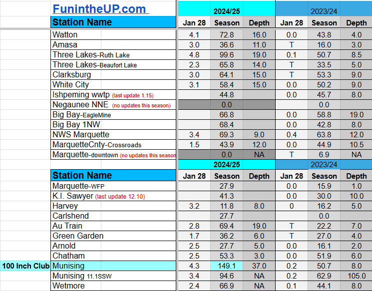
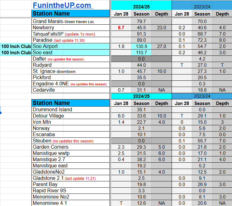
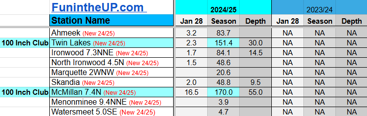
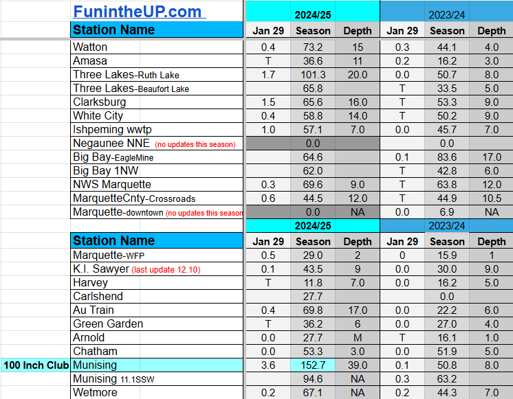
Most snowfall Jan 28: Newberry with 8.7 inches
Most snowfall, season to date: Painesdale with 187.6 inches
Biggest 24hr total this season: Soo Airport with 15.7 inches (11.30.24)
Most snowfall Jan 29: Munising with 3.6 inches
Most snowfall, season to date: Painesdale with 188.5 inches
Biggest 24hr total this season: Soo Airport with 15.7 inches (11.30.24)
If daily slot is 0" the station hasn't updated or recorded no snowfall.
Sometimes a station won't update that day and does the next day.
Tahquamenon Falls State Park only updates at the end of each month.
Keweenaw county and Houghton County Airport only update during the weekdays.
Sanderson Field Airport (Soo) updates next day.
Jan 28
NOTE: Hover cursor over images to enlarge snowfall totals.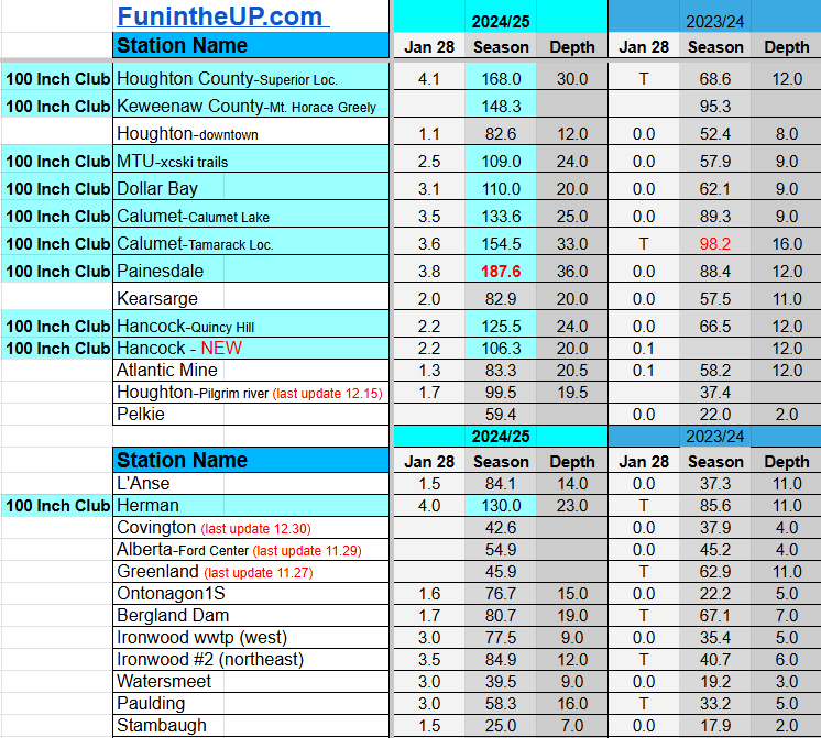
Jan 29
NOTE: Hover cursor over images to enlarge snowfall totals.


Do you enjoy FunintheUP videos and seeing the Snowfall Totals all winter? Consider supporting FunintheUP via PayPal - via Venmo
Thanks for following the U.P. Snow Totals page on FunintheUP.com
FunintheUP Youtube channel TourDaYoop Youtube channel FunintheUP on TikTok Yooper Steve on Facebook
Yooper Steve on Instagram
FunintheUP on Instagram
Snowfall on Jan Jan 24/25, 2025
Snowfall Reports by Yooper Steve
Daily UP Snowfall for 2024/25
Today's Notes:
This post first posted on the Yooper Report - FunintheUP Substack, it is an email newsletter that is sent out to subscribers.
Posted below are snow totals for Jan 24th and 25th.
Paid subscriptions on Substack allow these snowfall reports and fall color reports to continue each year. Thanks for subscribing to the Yooper Report become a subscriber to get snow totals and snowfall report/forecast emailed to you before they post here on the website.
Check out the FunintheUP Amazon Store - my recommended camping gear, winter clothing, Yooper rock hunting stuff, U.P. books worth reading
Join me on a Guided U.P. Tour to see places you’d never see on your own - UpperPeninsulaTours.com - adventures away from the crowds
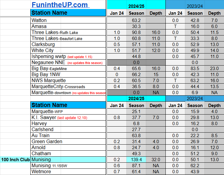
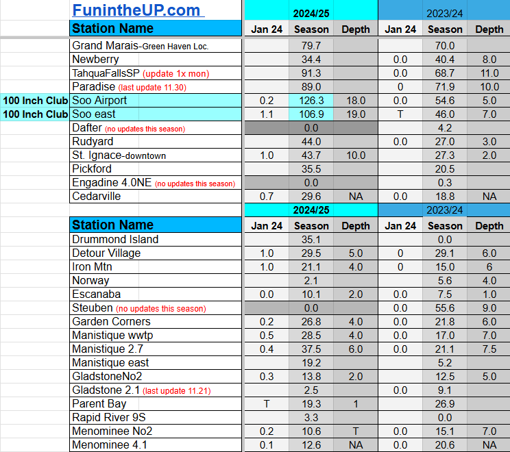
Most snowfall Jan 24: L'Anse with 2.5 inches
Most snowfall, season to date: Painesdale with 177.6 inches
Biggest 24hr total this season: Soo Airport with 15.7 inches (11.30.24)
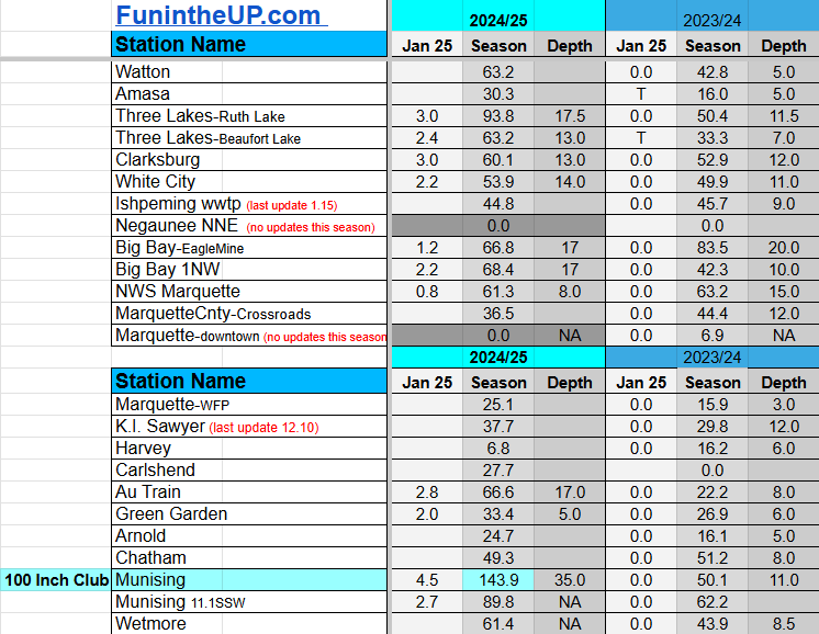
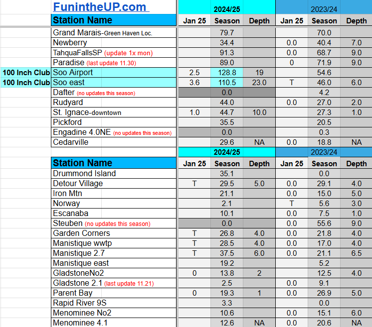
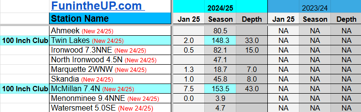
Most snowfall Jan 25: McMillan with 7.5 inches
Most snowfall, season to date: Painesdale with 182.1 inches
Biggest 24hr total this season: Soo Airport with 15.7 inches (11.30.24)
If daily slot is 0" the station hasn't updated or recorded no snowfall.
Sometimes a station won't update that day and does the next day.
Tahquamenon Falls State Park only updates at the end of each month.
Keweenaw county and Houghton County Airport only update during the weekdays.
Sanderson Field Airport (Soo) updates next day.
Jan 24
NOTE: Hover cursor over images to enlarge snowfall totals.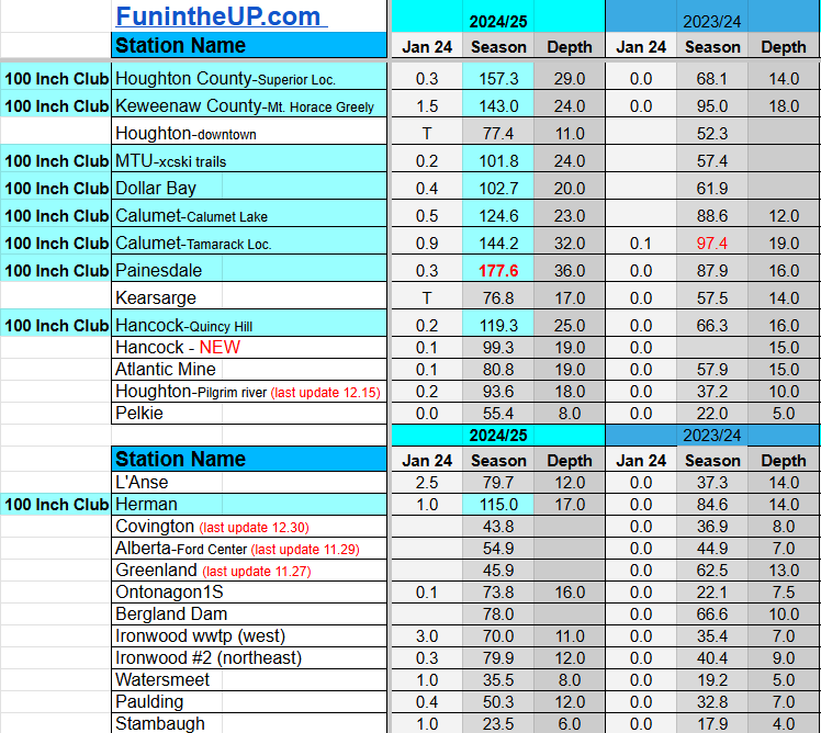
Jan 25
NOTE: Hover cursor over images to enlarge snowfall totals.
Do you enjoy FunintheUP videos and seeing the Snowfall Totals all winter? Consider supporting FunintheUP via PayPal - via Venmo
Thanks for following the U.P. Snow Totals page on FunintheUP.com
FunintheUP Youtube channel TourDaYoop Youtube channel FunintheUP on TikTok Yooper Steve on Facebook
Yooper Steve on Instagram
FunintheUP on Instagram
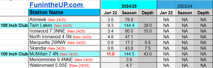
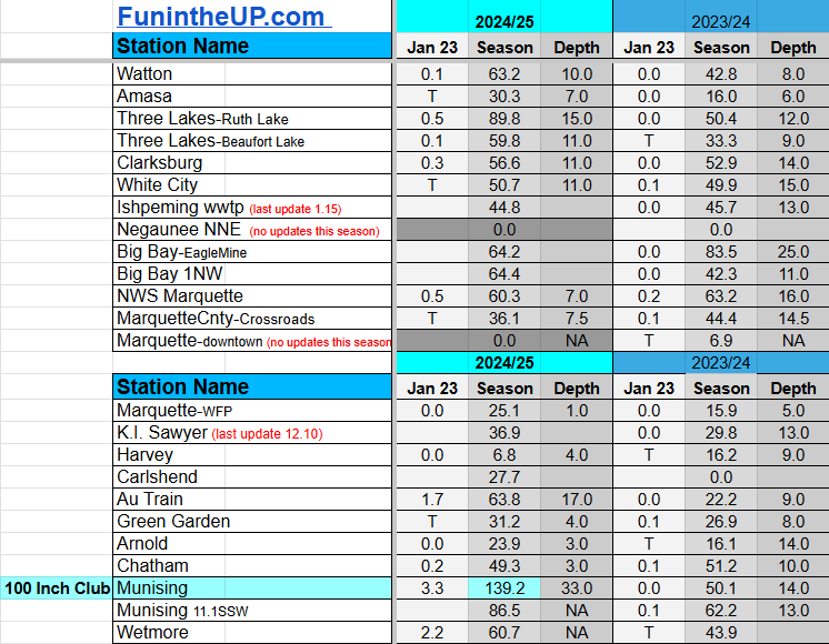
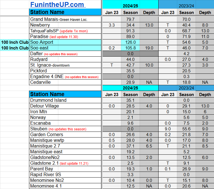
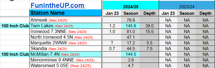
Snowfall on Jan 22/23, 2025
Snowfall Reports by Yooper Steve
Daily UP Snowfall for 2024/25
Today's Notes:
This post first posted on the Yooper Report - FunintheUP Substack, it is an email newsletter that is sent out to subscribers.
Posted below are snow totals for Jan 22nd and 23rd.
Paid subscriptions on Substack allow these snowfall reports and fall color reports to continue each year. Thanks for subscribing to the Yooper Report become a subscriber to get snow totals and snowfall report/forecast emailed to you before they post here on the website.
Check out the FunintheUP Amazon Store - my recommended camping gear, winter clothing, Yooper rock hunting stuff, U.P. books worth reading
Join me on a Guided U.P. Tour to see places you’d never see on your own - UpperPeninsulaTours.com - adventures away from the crowds
Most snowfall Jan 22: McMillan with 11 inches
Most snowfall, season to date: Painesdale with 176.5 inches
Biggest 24hr total this season: Soo Airport with 15.7 inches (11.30.24)
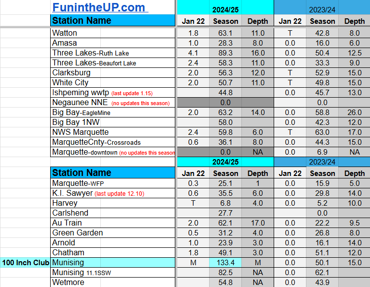
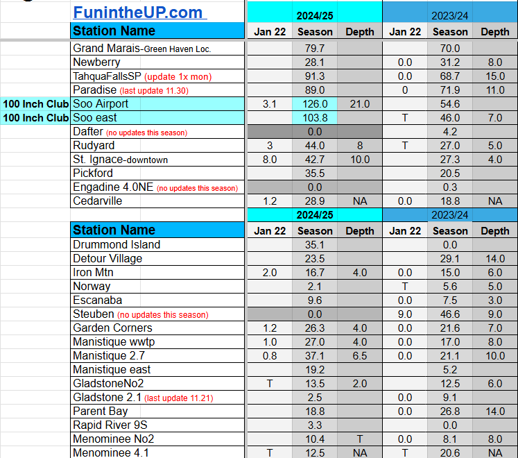
Most snowfall Jan 23: Newberry and Munising with 3.3 inches
Most snowfall, season to date: Painesdale with 177.3 inches
Biggest 24hr total this season: Soo Airport with 15.7 inches (11.30.24)
If daily slot is 0" the station hasn't updated or recorded no snowfall.
Sometimes a station won't update that day and does the next day.
Tahquamenon Falls State Park only updates at the end of each month.
Keweenaw county and Houghton County Airport only update during the weekdays.
Sanderson Field Airport (Soo) updates next day.
Jan 22
NOTE: Hover cursor over images to enlarge snowfall totals.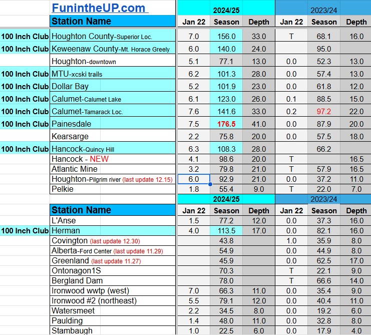
Jan 23
NOTE: Hover cursor over images to enlarge snowfall totals.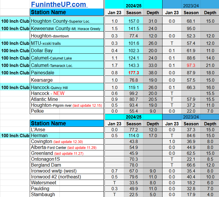
Do you enjoy FunintheUP videos and seeing the Snowfall Totals all winter? Consider supporting FunintheUP via PayPal - via Venmo
Thanks for following the U.P. Snow Totals page on FunintheUP.com
FunintheUP Youtube channel TourDaYoop Youtube channel FunintheUP on TikTok Yooper Steve on Facebook
Yooper Steve on Instagram
FunintheUP on Instagram
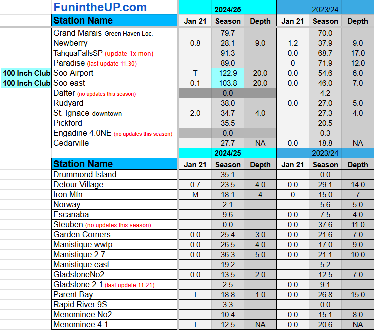
Snowfall on Jan 21, 2025
Snowfall Reports by Yooper Steve
Daily UP Snowfall for 2024/25
Today's Notes:
This post first posted on the Yooper Report - FunintheUP Substack, it is an email newsletter that is sent out to subscribers.
We saw some pretty cold temperatures across the Upper Peninsula the last 5 days, sub zero down to -30 in places like Stambaugh and -27 in Ironwood. Add in the wind chills and we saw -40+ below zero. I don’t know many people who really enjoy temperatures that cold, if you’re out there let me know. I enjoy around 10-15 degrees, I think that is a good range for cross country skiing, snowshoeing, sledding, or just being outside enjoying some winter activities. One thing about living in the Upper Peninsula of Michigan is that our temperatures don’t get to extreme and it stays pretty mild compared to places in Minnesota, plus we get plenty of snowfall for all kinds of winter fun.
Snow has been hard to come by across most of the U.P. during this cold spell, only the Copper Country and a little area near Munising has really seen any significant snowfall. We saw 10-20 inches through the Copper Country in the higher elevations from Twin Lakes to Calumet and spine of the Keweenaw. There was around 10-12 inches around Munising.
Today we saw a good 20 to 30 degrees swing the last 24hrs. Winds have shifted back into the NW snowbelts bringing lake effect to more areas in the Upper Peninsula. Other than snow tonight and tomorrow morning there won’t be much accumulation into the weekend. Things might change Monday and Tuesday as a low pressure system might dip down over the Upper Peninsula which could bring more lake effect.
As you can see above on the graphic Great Lakes ice coverage increased a little over the last few days, it should continue at a steady pace into the end of February and beginning of March when we usually see our greatest ice coverage.
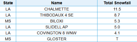
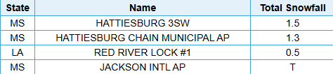
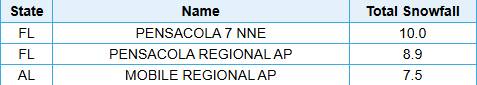
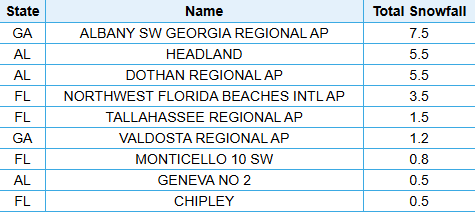
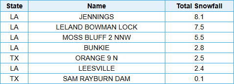
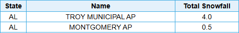
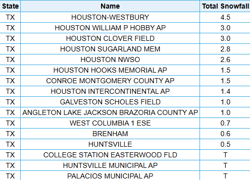
Making big weather news is snow in South Carolina, Florida, Texas, Georgia, Alabama, Mississippi, and Louisiana, below you can see some of the snow recorded on the 21st and 22nd in those states. Pretty crazy to see snow in those areas, this has to be once in a lifetime opportunity or nightmare for some people. Last time people in those areas in Florida saw snow like this was around 1954, I would say that is once in a lifetime event for people in that area.
Make sure to check out some snowfall in some areas of those southern states. I put those snow totals below the U.P. snow totals for today.
Paid subscriptions on Substack allow these snowfall reports and fall color reports to continue each year. Thanks for subscribing to the Yooper Report become a subscriber to get snow totals and snowfall report/forecast emailed to you before they post here on the website.
Check out the FunintheUP Amazon Store - my recommended camping gear, winter clothing, Yooper rock hunting stuff, U.P. books worth reading
Join me on a Guided U.P. Tour to see places you’d never see on your own - UpperPeninsulaTours.com - adventures away from the crowds
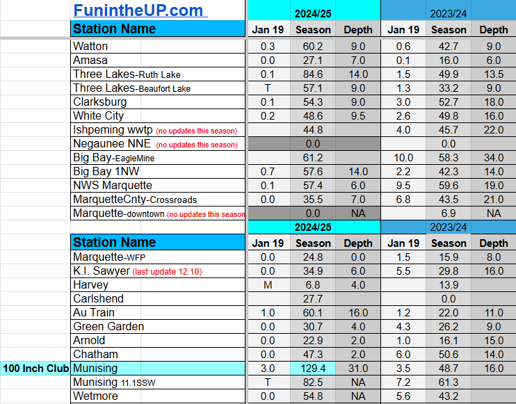
Most snowfall Jan 21: Painesdale with 7.2 inches
Most snowfall, season to date: Painesdale with 162.1 inches
Biggest 24hr total this season: Soo Airport with 15.7 inches (11.30.24)
If daily slot is 0" the station hasn't updated or recorded no snowfall.
Sometimes a station won't update that day and does the next day.
Tahquamenon Falls State Park only updates at the end of each month.
Keweenaw county and Houghton County Airport only update during the weekdays.
Sanderson Field Airport (Soo) updates next day.
Jan 21
NOTE: Hover cursor over images to enlarge snowfall totals.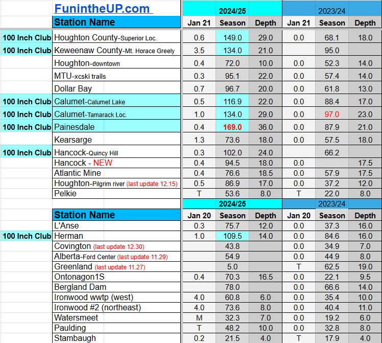


Snow Totals for Snow Event in the South East Jan 21st and 22nd, 2025
Do you enjoy FunintheUP videos and seeing the Snowfall Totals all winter? Consider supporting FunintheUP via PayPal - via Venmo
Thanks for following the U.P. Snow Totals page on FunintheUP.com
FunintheUP Youtube channel TourDaYoop Youtube channel FunintheUP on TikTok Yooper Steve on Facebook
Yooper Steve on Instagram
FunintheUP on Instagram
Snowfall on Jan 18/19/20, 2025
Snowfall Reports by Yooper Steve
Daily UP Snowfall for 2024/25
Today's Notes:
This post first posted on the Yooper Report - FunintheUP Substack, it is an email newsletter that is sent out to subscribers.
Cold and Crispy
It sure is cold, not the coldest ever but the coldest we have had this winter and tonight it is dropping even more at least ten decrease less than last nights lows. We will see much of the Upper Peninsula hit double digit negatives with some places possibly seeing even -20 to -25 overnight. It certainly was a crispy one today, I had a high of 3 degrees in Calumet and then it dropped to -5 by 8pm. Will be interesting to see what the low temps were across the Upper Peninsula tonight when all the data is shown tomorrow, I am sure the NWS Marquette office will post on their facebook page by early afternoon Monday.Cancelled Hike
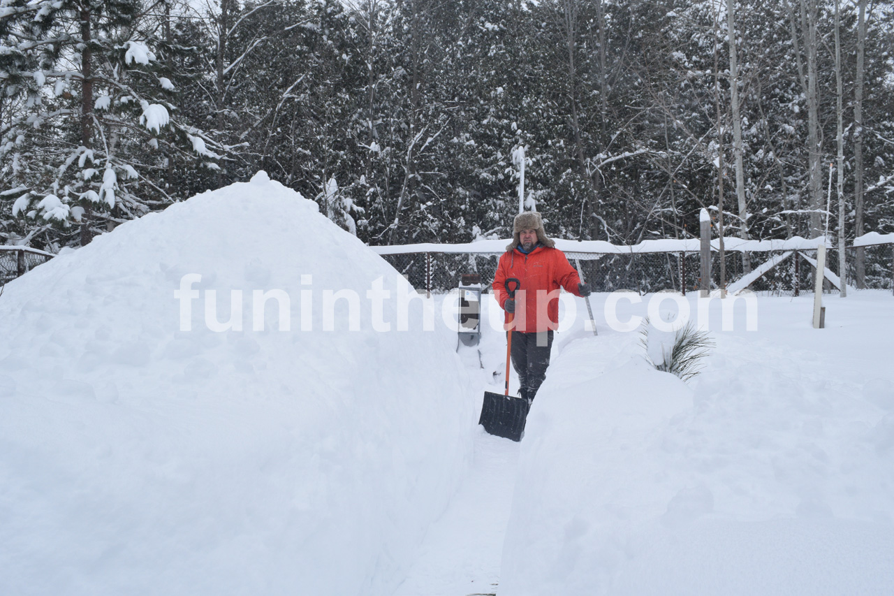
Our group hike got cancelled today which was going to be at O Kun de kun falls, so I decided to meet Zack from the group over at Victoria dam to check out the falls and do some sledding. Road conditions weren’t the best mostly because of the snow being blown up by vehicles you were following or passerby vehicles.At Victoria dam the temp was 1 or 2 degrees with up to a -22 wind chill at times. By the time we were heading out temps really started dropping to -10 and -11 degrees already around 6pm. It was pretty chilly that’s for sure. The falls were running as they are still working on the powerhouse down below along the river. There was a good amount of snow in the area, I measured between 6-7 inches that fell overnight Saturday into Sunday morning in the area, a good blanket of snow for some winter fun.
The falls were flowing pretty good but not as good as they were a few weeks ago but with all the fresh white snow it was a nice pretty scene if you could deal the wind on your face.
After we checked the falls out we did some sledding, I had 3 sleds with me. We went sledding down the Victoria road, the conditions for it were perfect. If you have ever been to the Victoria dam you know how steep that road is as it drops down to the dam.
Heading back to Houghton snowfall and blowing snow picked up pretty good and there was so much traffic kicking up snow it made for a really slow ride home going 20-25mph for almost 30 miles of the 40 mile drive. When we left Rockland the skies were clear and you could see the stars. I did a LIVE video on facebook if you want to watch it.
Snow forecast
Below is what I posted for my forecasted snow totals last night Saturday into Monday afternoon, we shall see how close I came with the numbers, some might be a little higher, but overall I think I’ll be pretty close. Won’t know until Tuesday when I post the Monday snow totals, then can add up the Sat, Sun, and Monday totals and see how I did, ohh isn’t winter fun!Ironwood-Wakefield 2-4"
Bergland/White Pine 5-8"
Ontonagon 1-3"
Twin Lakes to Painesdale 6-10"
Houghton/Hancock 4-6"
Calumet/Central - 8-12"
L'Anse/Baraga 1-3"
Alberta/Covington Jct 6-8"
Negaunee/Ishpeming 4-6"
Marquette city Trace-2"
Munising/Melstrand/McMillan 4-8"
Newberry/Paradise 4-6"
Soo - 1-2"
St Ignace Trace - 1"
Manistique/Escanaba 0-1"
Iron Mtn - 1-2"
Menominee Trace to 1"
Stay warm out there and I’ll see you on the next update, if you’re a paid subscribe you can view the snow totals for Jan 15-18th below. Thanks for being a subscriber and supporting FunintheUP Snow reports
—Yooper Steve
Paid subscriptions on Substack allow these snowfall reports and fall color reports to continue each year. Thanks for subscribing to the Yooper Report become a subscriber to get snow totals and snowfall report/forecast emailed to you before they post here on the website.
Check out the FunintheUP Amazon Store - my recommended camping gear, winter clothing, Yooper rock hunting stuff, U.P. books worth reading
Join me on a Guided U.P. Tour to see places you’d never see on your own - UpperPeninsulaTours.com - adventures away from the crowds
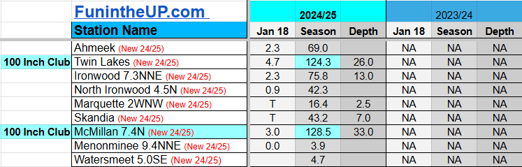
Most snowfall Jan 18: Houghton county with 7.0 inches
Most snowfall, season to date: Painesdale with 154.9 inches
Biggest 24hr total this season: Soo Airport with 15.7 inches (11.30.24)
Most snowfall Jan 19: P6.5 with 7.2 inches
Most snowfall, season to date: Painesdale with 162.1 inches
Biggest 24hr total this season: Soo Airport with 15.7 inches (11.30.24)
Most snowfall Jan 20: Painesdale with 6.5 inches
Most snowfall, season to date: Painesdale with 168.6 inches
Biggest 24hr total this season: Soo Airport with 15.7 inches (11.30.24)
Do you enjoy FunintheUP videos and seeing the Snowfall Totals all winter? Consider supporting FunintheUP via PayPal - via Venmo
Become a monthly FunintheUP Fan Supporter
Thanks for following the UP Snow Totals page on FunintheUP.com
FunintheUP Youtube channel TourDaYoop Youtube channel FunintheUP on TikTok Yooper Steve on Facebook
Yooper Steve on Instagram
FunintheUP on Instagram
If daily slot is 0" the station hasn't updated or recorded no snowfall.
Sometimes a station won't update that day and does the next day.
Tahquamenon Falls State Park only updates at the end of each month.
Keweenaw county and Houghton County Airport only update during the weekdays.
Sanderson Field Airport (Soo) updates next day.
Jan 18
NOTE: Hover cursor over images to enlarge snowfall totals.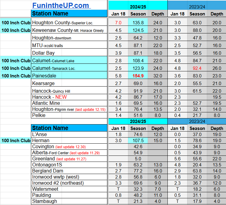
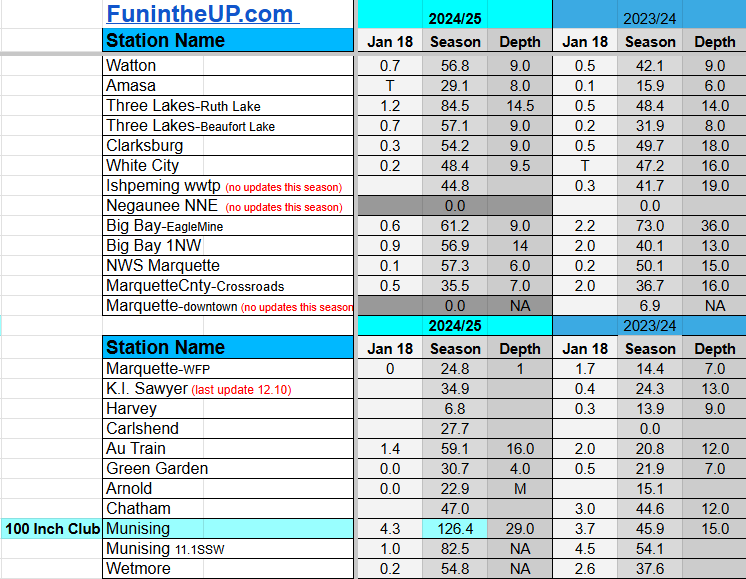
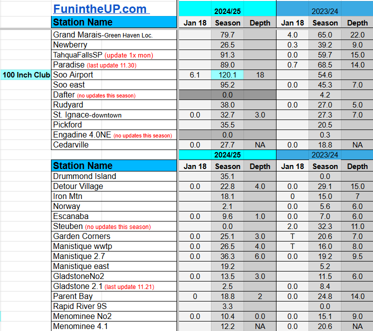
Jan 19
NOTE: Hover cursor over images to enlarge snowfall totals.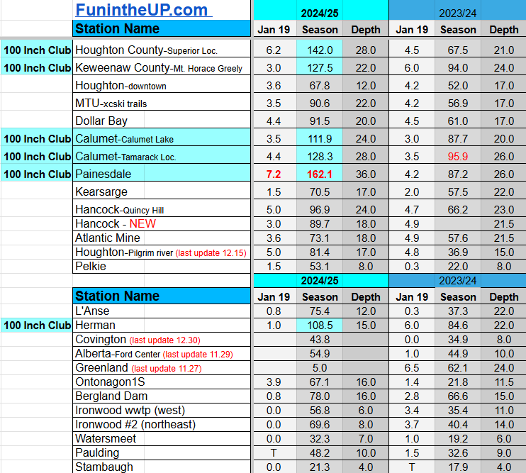


Jan 20
NOTE: Hover cursor over images to enlarge snowfall totals.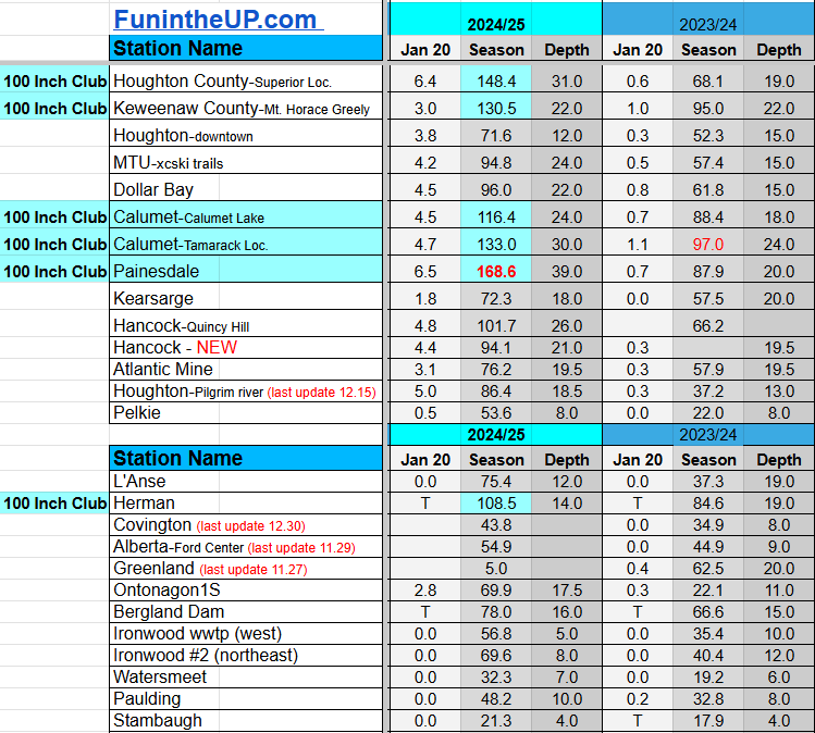
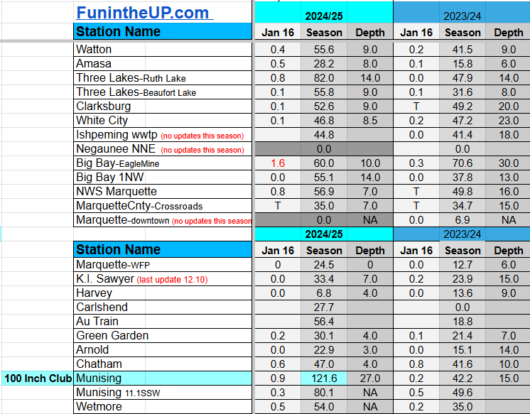
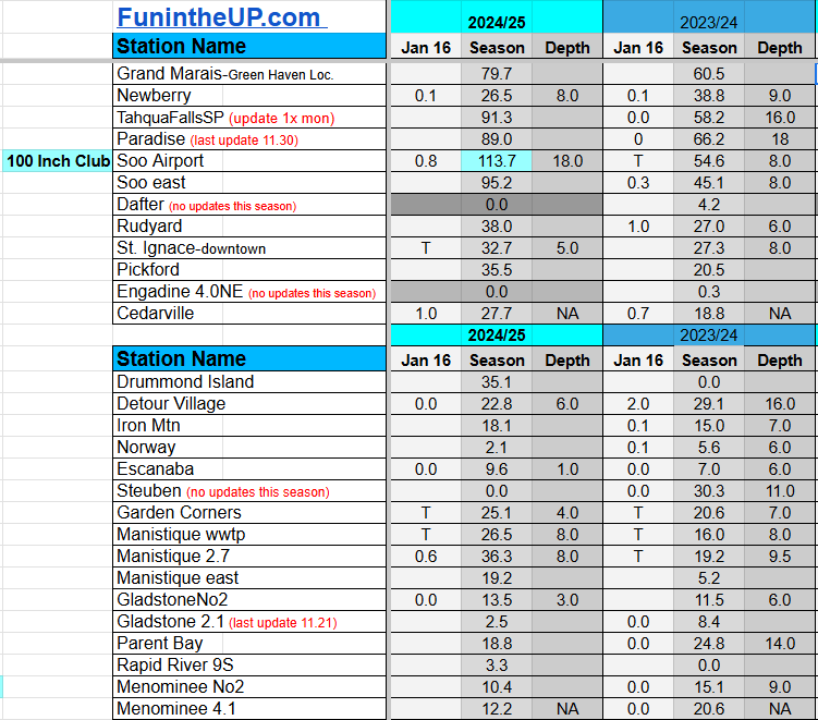
Snowfall on Jan 16/17, 2025
Snowfall Reports by Yooper Steve
Daily UP Snowfall for 2024/25
Today's Notes:
Snow totals for Jan 16th and 17th are listed below.
Paid subscriptions on Substack allow these snowfall reports and fall color reports to continue each year. Thanks for subscribing to the Yooper Report become a subscriber to get snow totals and snowfall report/forecast emailed to you before they post here on the website.
Check out the FunintheUP Amazon Store - my recommended camping gear, winter clothing, Yooper rock hunting stuff, U.P. books worth reading
Join me on a Guided U.P. Tour to see places you’d never see on your own - UpperPeninsulaTours.com - adventures away from the crowds
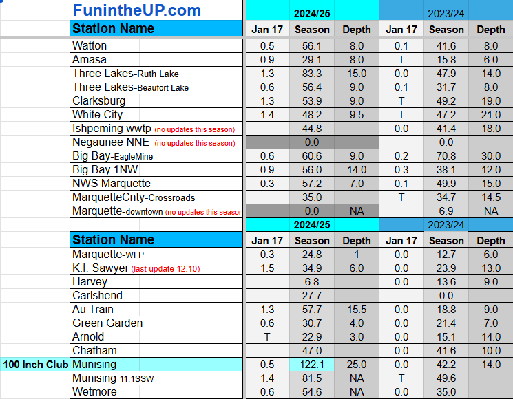
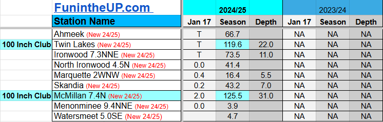
Most snowfall Jan 17: Paulding with 2.1 inches
Most snowfall, season to date: Painesdale with 149.1 inches
Biggest 24hr total this season: Soo Airport with 15.7 inches (11.30.24)
Do you enjoy FunintheUP videos and seeing the Snowfall Totals all winter? Consider supporting FunintheUP via PayPal - via Venmo
Become a monthly FunintheUP Fan Supporter
Thanks for following the UP Snow Totals page on FunintheUP.com
FunintheUP Youtube channel
TourDaYoop Youtube channel
FunintheUP on TikTok
Yooper Steve on Facebook
Yooper Steve on Instagram
FunintheUP on Instagram
If daily slot is 0" the station hasn't updated or recorded no snowfall.
Sometimes a station won't update that day and does the next day.
Tahquamenon Falls State Park only updates at the end of each month.
Keweenaw county and Houghton County Airport only update during the weekdays.
Sanderson Field Airport (Soo) updates next day.
Jan 16
NOTE: Hover cursor over images to enlarge snowfall totals.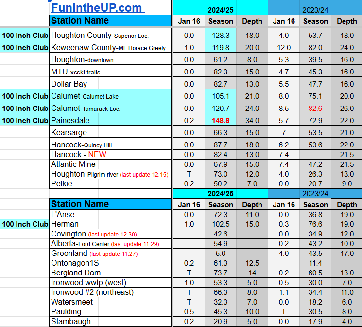

Jan 17
NOTE: Hover cursor over images to enlarge snowfall totals.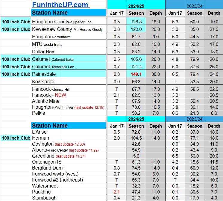
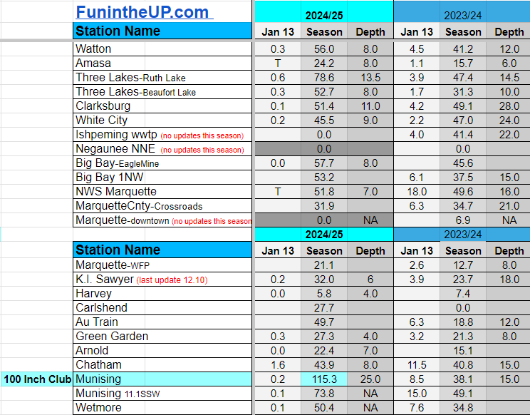
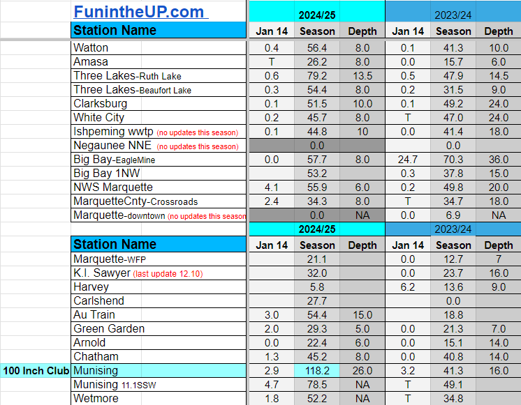
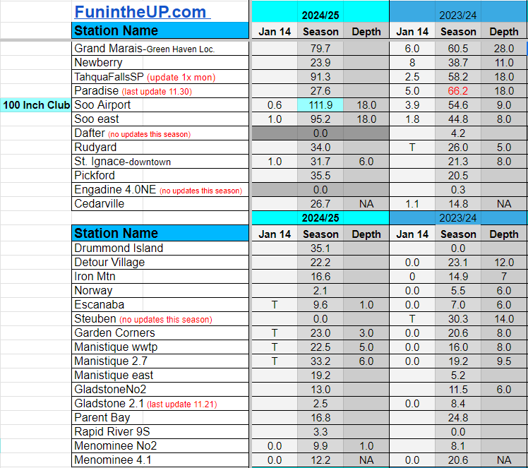
Snowfall on Jan 13/14/15, 2025
Snowfall Reports by Yooper Steve
Daily UP Snowfall for 2024/25
Today's Notes:
Snow totals for Jan 13th, 14th, and 15th are listed below.
Paid subscriptions on Substack allow these snowfall reports and fall color reports to continue each year. Thanks for subscribing to the Yooper Report become a subscriber to get snow totals and snowfall report/forecast emailed to you before they post here on the website.
Check out the FunintheUP Amazon Store - my recommended camping gear, winter clothing, Yooper rock hunting stuff, U.P. books worth reading
Join me on a Guided U.P. Tour to see places you’d never see on your own - UpperPeninsulaTours.com - adventures away from the crowds
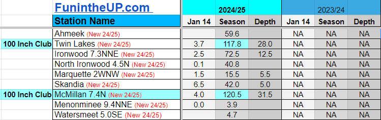
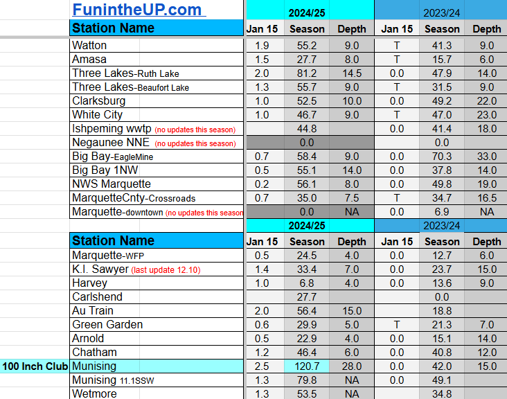
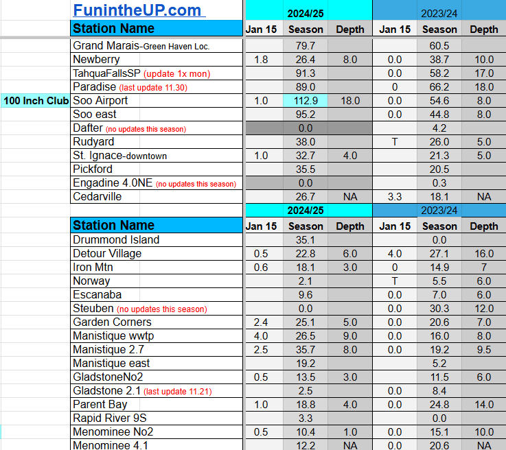
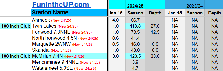
Most snowfall Jan 15: Ironwood #2 with 4.5 inches
Most snowfall, season to date: Painesdale with 148.6 inches
Biggest 24hr total this season: Soo Airport with 15.7 inches (11.30.24)
Do you enjoy FunintheUP videos and seeing the Snowfall Totals all winter? Consider supporting FunintheUP via PayPal - via Venmo
Become a monthly FunintheUP Fan Supporter
Thanks for following the UP Snow Totals page on FunintheUP.com
FunintheUP Youtube channel
TourDaYoop Youtube channel
FunintheUP on TikTok
Yooper Steve on Facebook
Yooper Steve on Instagram
FunintheUP on Instagram
If daily slot is 0" the station hasn't updated or recorded no snowfall.
Sometimes a station won't update that day and does the next day.
Tahquamenon Falls State Park only updates at the end of each month.
Keweenaw county and Houghton County Airport only update during the weekdays.
Sanderson Field Airport (Soo) updates next day.
Jan 13
NOTE: Hover cursor over images to enlarge snowfall totals.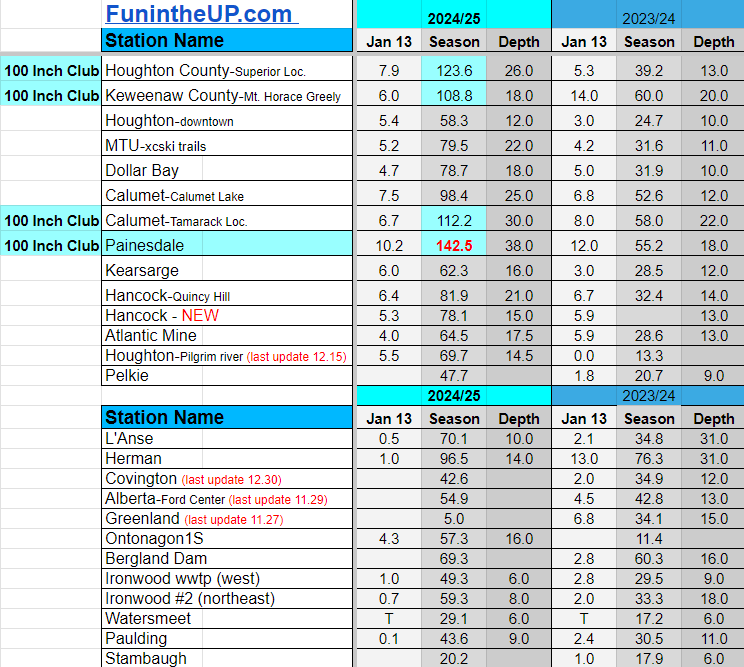


Jan 14
NOTE: Hover cursor over images to enlarge snowfall totals.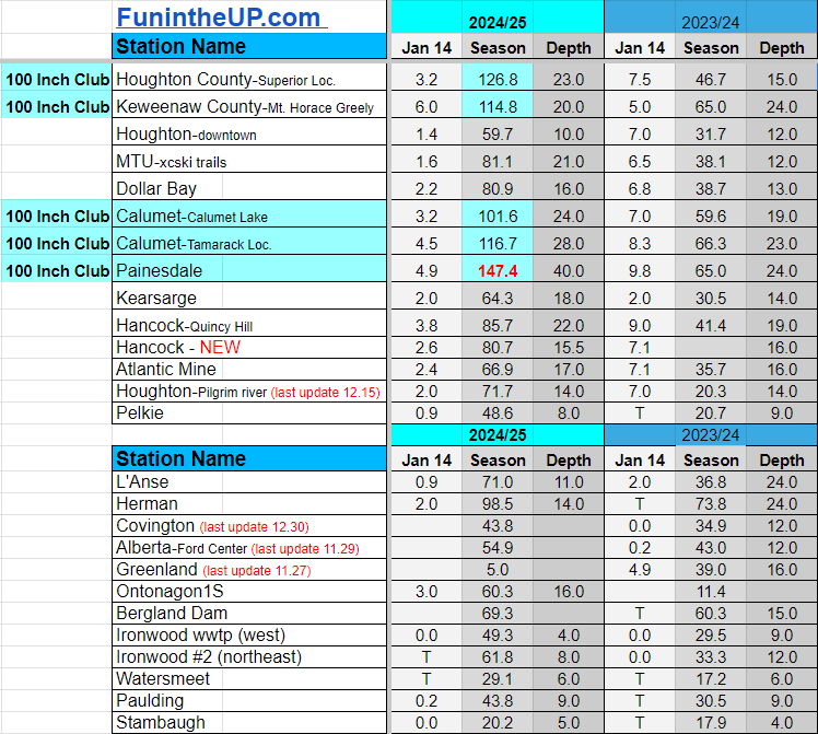
Jan 15
NOTE: Hover cursor over images to enlarge snowfall totals.
Snowfall on Jan 10/11/12, 2025
Snowfall Reports by Yooper Steve
Daily UP Snowfall for 2024/25
Today's Notes:
Snow totals for Jan 10th, 11th, and 12th are listed below.
Paid subscriptions on Substack allow these snowfall reports and fall color reports to continue each year. Thanks for subscribing to the Yooper Report become a subscriber to get snow totals and snowfall report/forecast emailed to you before they post here on the website.
Check out the FunintheUP Amazon Store - my recommended camping gear, winter clothing, Yooper rock hunting stuff, U.P. books worth reading
Join me on a Guided U.P. Tour to see places you’d never see on your own - UpperPeninsulaTours.com - adventures away from the crowds
Most snowfall Jan 12: Painesdale with 6.5 inches
Most snowfall, season to date: Painesdale with 132.3 inches
Biggest 24hr total this season: Soo Airport with 15.7 inches (11.30.24)
Do you enjoy FunintheUP videos and seeing the Snowfall Totals all winter? Consider supporting FunintheUP via PayPal - via Venmo
Become a monthly FunintheUP Fan Supporter
Thanks for following the UP Snow Totals page on FunintheUP.com
FunintheUP Youtube channel
TourDaYoop Youtube channel
FunintheUP on TikTok
Yooper Steve on Facebook
Yooper Steve on Instagram
FunintheUP on Instagram
If daily slot is 0" the station hasn't updated or recorded no snowfall.
Sometimes a station won't update that day and does the next day.
Tahquamenon Falls State Park only updates at the end of each month.
Keweenaw county and Houghton County Airport only update during the weekdays.
Sanderson Field Airport (Soo) updates next day.
Jan 10
NOTE: Hover cursor over images to enlarge snowfall totals.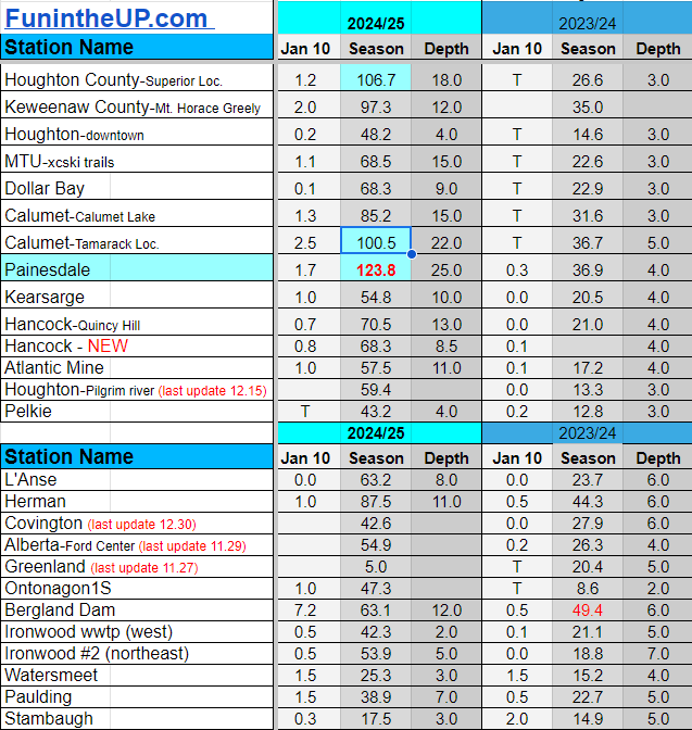
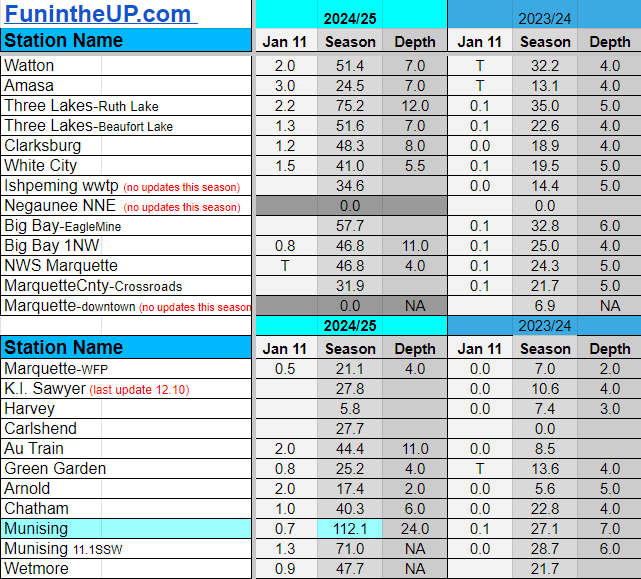
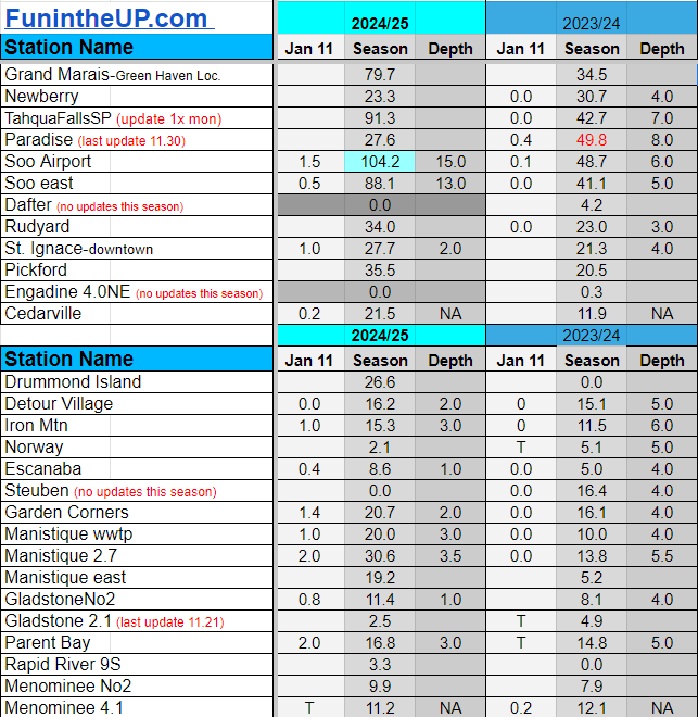
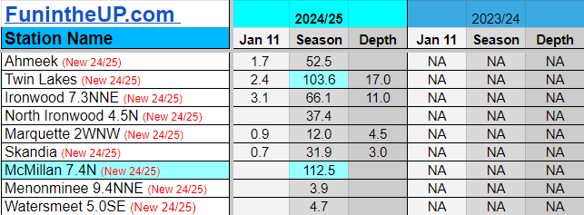
Jan 11
NOTE: Hover cursor over images to enlarge snowfall totals.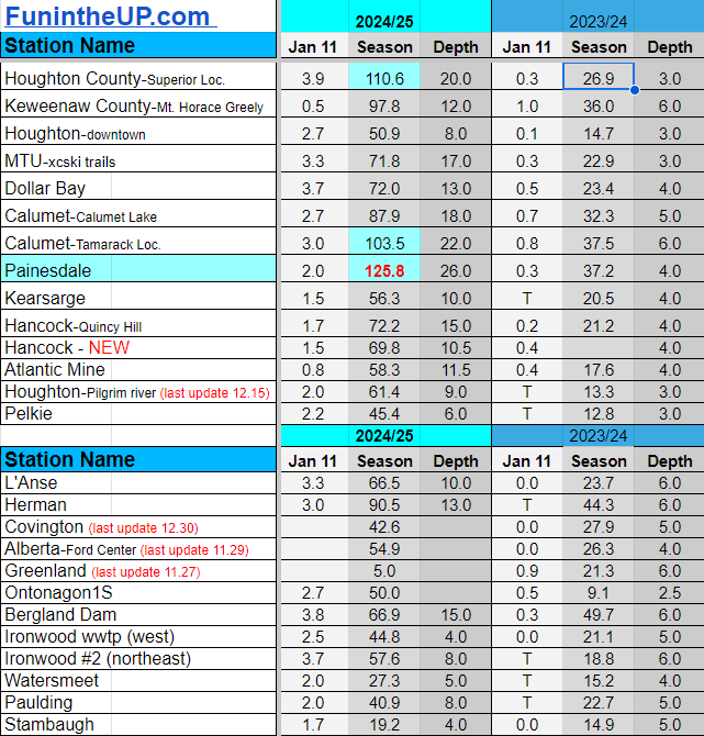
Jan 12
NOTE: Hover cursor over images to enlarge snowfall totals.


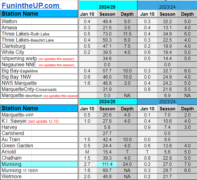
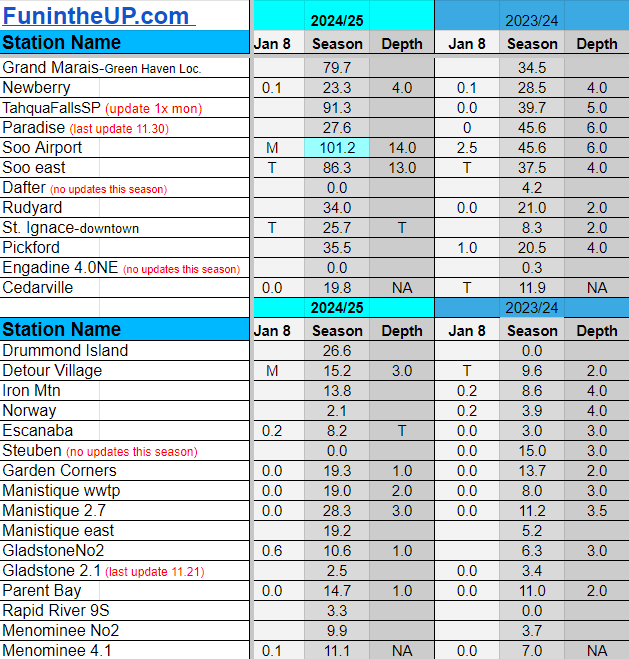
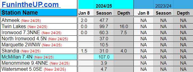
Snowfall on Jan 7/8/9, 2025
Snowfall Reports by Yooper Steve
Daily UP Snowfall for 2024/25
Today's Notes:
Snow totals for Jan 7th, 8th, and 9th are listed below.
Paid subscriptions on Substack allow these snowfall reports and fall color reports to continue each year. Thanks for subscribing to the Yooper Report become a subscriber to get snow totals and snowfall report/forecast emailed to you before they post here on the website.
Check out the FunintheUP Amazon Store - my recommended camping gear, winter clothing, Yooper rock hunting stuff, U.P. books worth reading
Join me on a Guided U.P. Tour to see places you’d never see on your own - UpperPeninsulaTours.com - adventures away from the crowds
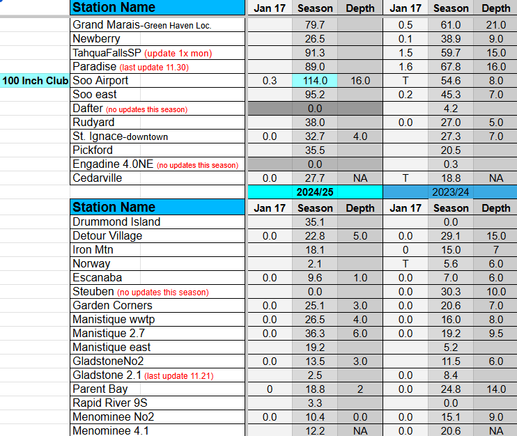
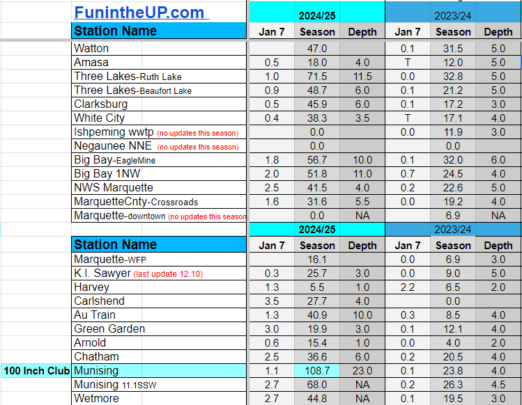
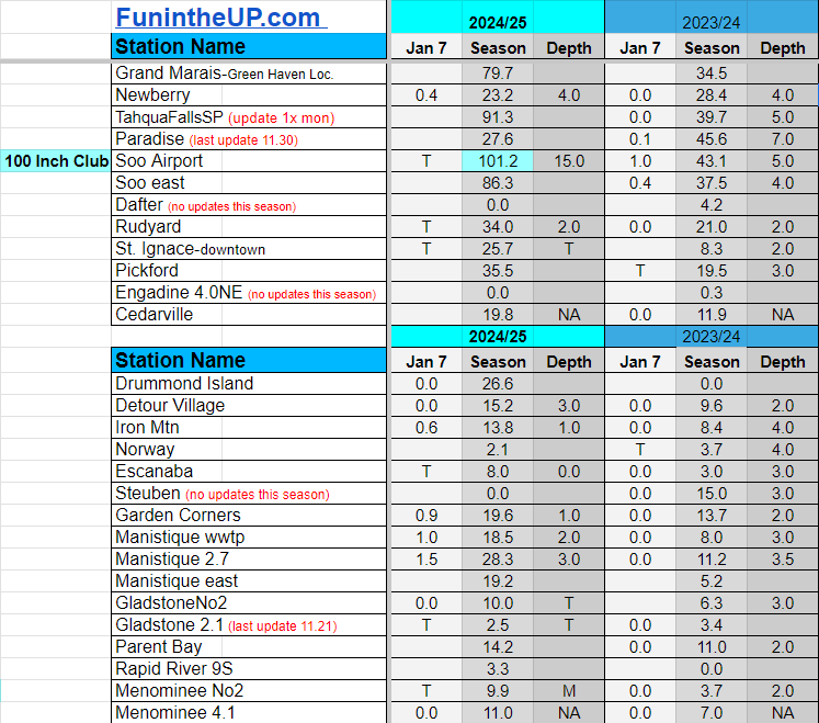
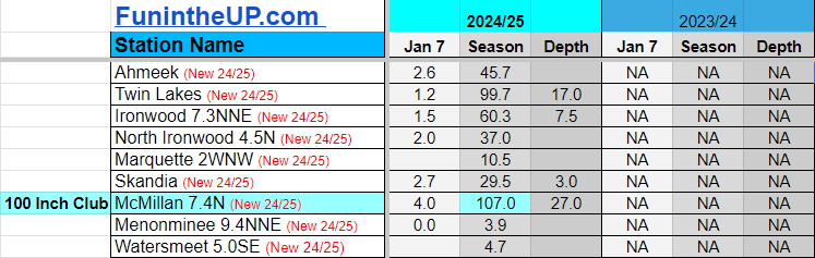
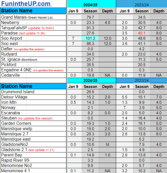
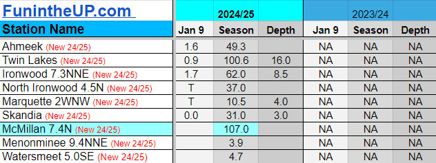
Most snowfall Jan 9: Keweenaw county with 2 inches
Most snowfall, season to date: Painesdale with 122.1 inches
Biggest 24hr total this season: Soo Airport with 15.7 inches (11.30.24)
Do you enjoy FunintheUP videos and seeing the Snowfall Totals all winter? Consider supporting FunintheUP via PayPal - via Venmo
Become a monthly FunintheUP Fan Supporter
Thanks for following the UP Snow Totals page on FunintheUP.com
FunintheUP Youtube channel
TourDaYoop Youtube channel
FunintheUP on TikTok
Yooper Steve on Facebook
Yooper Steve on Instagram
FunintheUP on Instagram
If daily slot is 0" the station hasn't updated or recorded no snowfall.
Sometimes a station won't update that day and does the next day.
Tahquamenon Falls State Park only updates at the end of each month.
Keweenaw county and Houghton County Airport only update during the weekdays.
Sanderson Field Airport (Soo) updates next day.
Jan 7
NOTE: Hover cursor over images to enlarge snowfall totals.
Jan 8
NOTE: Hover cursor over images to enlarge snowfall totals.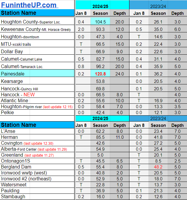

Jan 9
NOTE: Hover cursor over images to enlarge snowfall totals.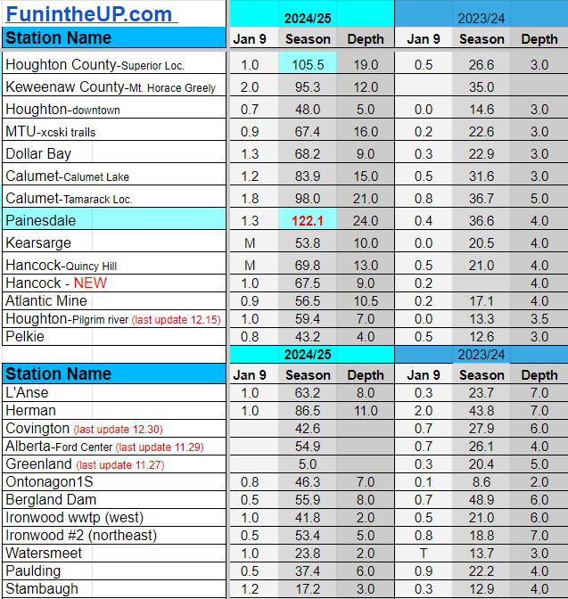

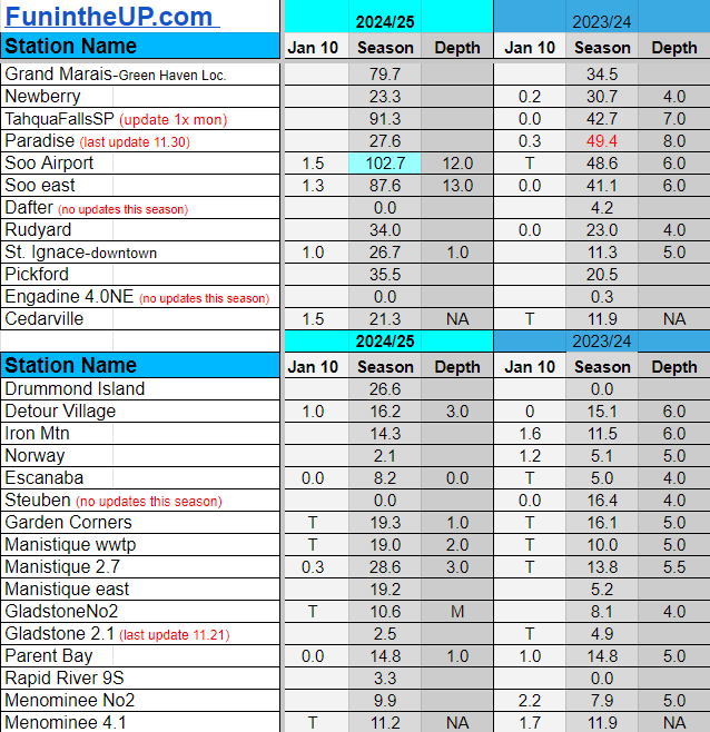
Snowfall on Jan 4/5/6, 2025
Snowfall Reports by Yooper Steve
Daily UP Snowfall for 2024/25
Today's Notes:
Snow is slowly adding up, some places more than others. Considering how little snow we had until the middle of January last year we will take all we can get.
=
If you are a snowmobiler it’s been a bit tough to find good snow unless you’re in southern Houghton county, eastern Ontonagon county, Alger county, Luce county, Schoolcraft county and parts of Chippewa county. Snow conditions have been rideable but turned pretty rough around Christmas into the New Year and it wasn’t until these last few days when we got another blast of lake effect and colder temperatures that things improved a bit.
Cross country ski trails have improved as well across these same areas. The SISU ski fest in the western UP got cancelled again for the lack of snow that’s how bad it is over near Ironwood and Bessemer for now this season again.
We will see a bit of light lake effect the next couple days, but nothing that warrants any Winter Weather Warnings or Advisories at this time.
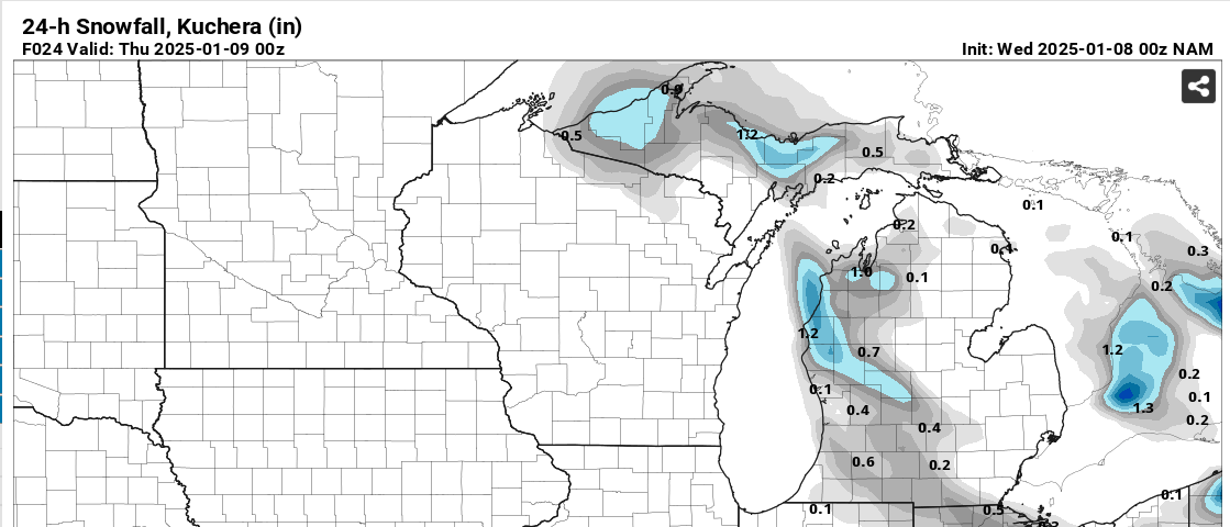
The 24hr Kuchera forecast shows most snowfall will be around the Porkies with most of Ontonagon county seeing some snow as well as Southern Houghton county. Looking out east we can see a little snow south of Marquette and much of Alger county and into the Schoolcraft county line area.
Wednesday night we should see south winds move cloud cover to the north over Lake Superior which should open up opportunities for star gazing, not total clear skies but enough to view some stars. Temps should dip into the single digits across much of the Upper Peninsula especially the western and central UP off of Lake Superior.
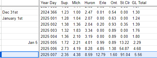
Models don’t really show much as far as precipitation into the weekend, but it is around the beginning of the coming week when it appears a clipper will be arriving that should bring snow back into the NW snowbelts. We shall see how things develop over the weekend as clipper arrives and shortwave moves out during the weekend. Cold air lingers and Lake Superior ice coverage is still low so anything can happen.
Paid subscriptions on Substack allow these snowfall reports and fall color reports to continue each year. Thanks for subscribing to the Yooper Report become a subscriber to get snow totals and snowfall report/forecast emailed to you before they post here on the website.
Check out the FunintheUP Amazon Store - my recommended camping gear, winter clothing, Yooper rock hunting stuff, U.P. books worth reading
Join me on a Guided U.P. Tour to see places you’d never see on your own - UpperPeninsulaTours.com - adventures away from the crowds
Most snowfall Jan 6: Manistique 2.7 with 0.4 inches
Most snowfall, season to date: Painesdale with 117.2 inches
Biggest 24hr total this season: Soo Airport with 15.7 inches (11.30.24)
Do you enjoy FunintheUP videos and seeing the Snowfall Totals all winter? Consider supporting FunintheUP via PayPal - via Venmo
Become a monthly FunintheUP Fan Supporter
Thanks for following the UP Snow Totals page on FunintheUP.com
FunintheUP Youtube channel
TourDaYoop Youtube channel
FunintheUP on TikTok
Yooper Steve on Facebook
Yooper Steve on Instagram
FunintheUP on Instagram
If daily slot is 0" the station hasn't updated or recorded no snowfall.
Sometimes a station won't update that day and does the next day.
Tahquamenon Falls State Park only updates at the end of each month.
Keweenaw county and Houghton County Airport only update during the weekdays.
Sanderson Field Airport (Soo) updates next day.
Jan 4
NOTE: Hover cursor over images to enlarge snowfall totals.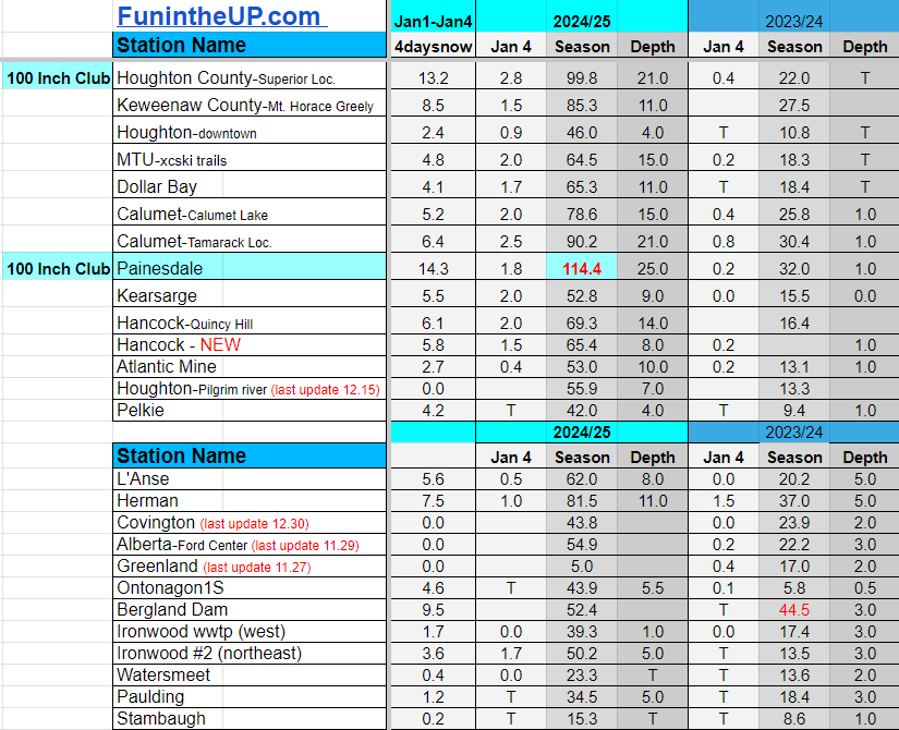
Jan 5
NOTE: Hover cursor over images to enlarge snowfall totals.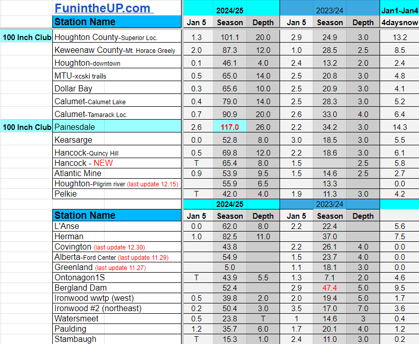
Jan 6
NOTE: Hover cursor over images to enlarge snowfall totals.
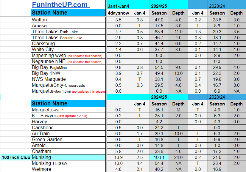
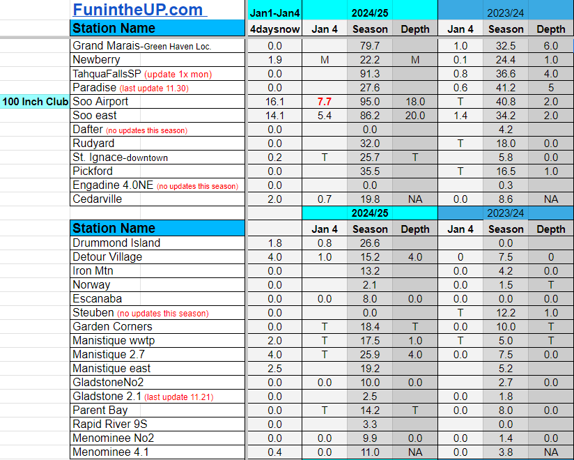
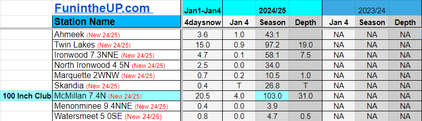
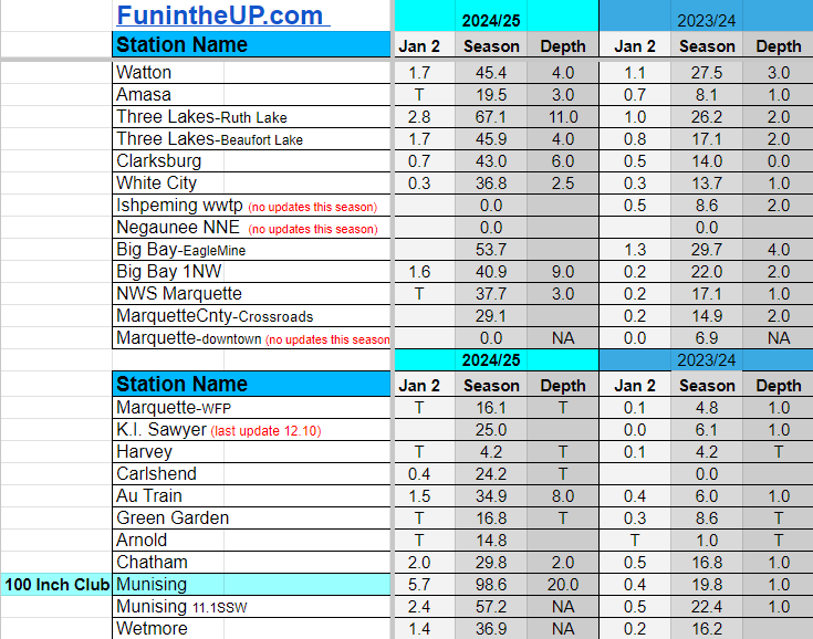
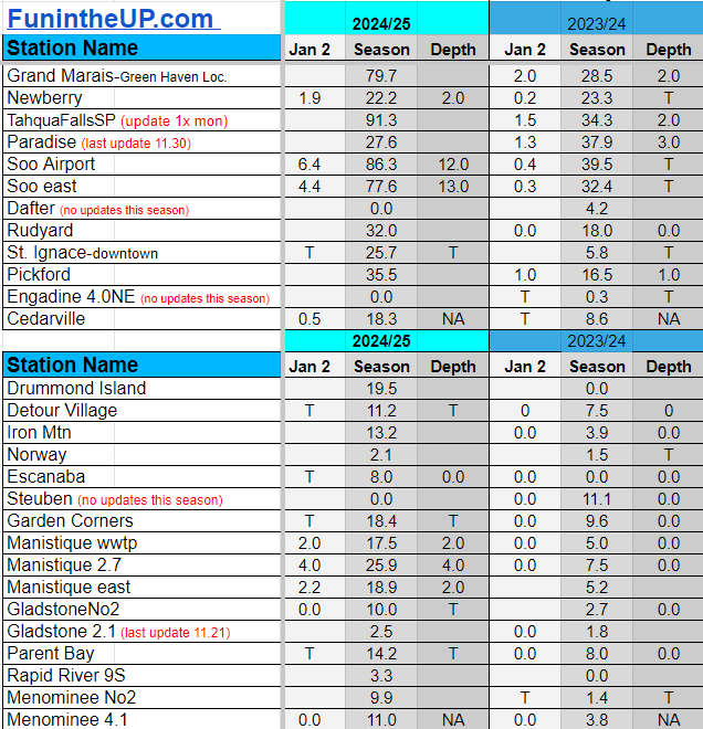
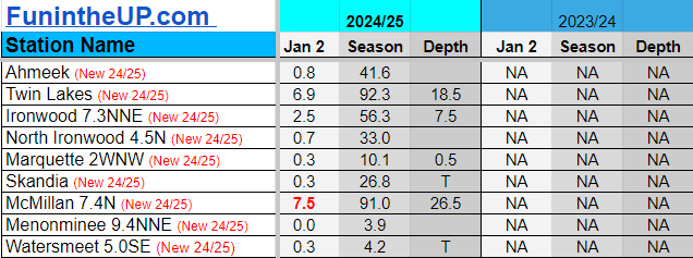
Snowfall on Jan 1/2/3, 2025
Snowfall Reports by Yooper Steve
Daily UP Snowfall for 2024/25
Today's Notes:
Well 2024 is out and 2025 is in. I hope everyone had a wonderful Christmas and a enjoyed rolling into the new year of 2025.
On the weather side of the final days of 2024 it wasn’t to interesting, but it was kind of nice to have a few warmer days and no snow to have to shovel for the last 12 days, that is now changing as we enter 2025.
After the second half of December with no snow, we welcome what little snow we have gotten these last few days.
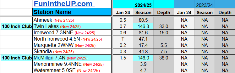
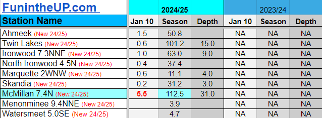
Right now we have two snow stations that have joined the 100 Inch Club with a handful of others that should join soon, perhaps this coming week.
Snowiest places these last few days were around Painesdale to Twin Lakes, north of Bergland into the interior portions of the Porkies and east of Munising and NE Newberry and McMillan, and localized near the Soo. Other places in the UP saw no snow and up to an inch or two.
Most of the Upper Peninsula cleared up late morning into the afternoon and the areas near Munising to the Soo were still experiencing some lighter lake effect banding into early evening hours, but that should be heading out now.
Lake effect snow is hard to predict and where we are located in the US makes it harder. We have so many things that can affect how it snows in the Upper Peninsula and where it snows. Snow totals can be affected by air temps at different levels, varying Lake Superior temps, ice coverage, abrupt elevation changes, valleys, cliffs, bays, Arctic air, southern moisture, wind and speed across the water and across land, directions of winds and a lot more.
The Upper Peninsula is a unique place, unique in many ways and not just weather and that’s what we love about it. Weather, especially winter weather we really embrace, we love to talk about our snowfall, being it has some of the snowiest locations east of the Rocky Mountains.
Little snow is expected in the next few days as temps stay a bit colder through Wednesday and getting back into the low 20s by Thursday across much of the U.P. into the weekend.
Paid subscriptions on Substack allow these snowfall reports and fall color reports to continue each year. Thanks for subscribing to the Yooper Report become a subscriber to get snow totals and snowfall report/forecast emailed to you before they post here on the website.
Check out the FunintheUP Amazon Store - my recommended camping gear, winter clothing, Yooper rock hunting stuff, U.P. books worth reading
Join me on a Guided U.P. Tour to see places you’d never see on your own - UpperPeninsulaTours.com - adventures away from the crowds
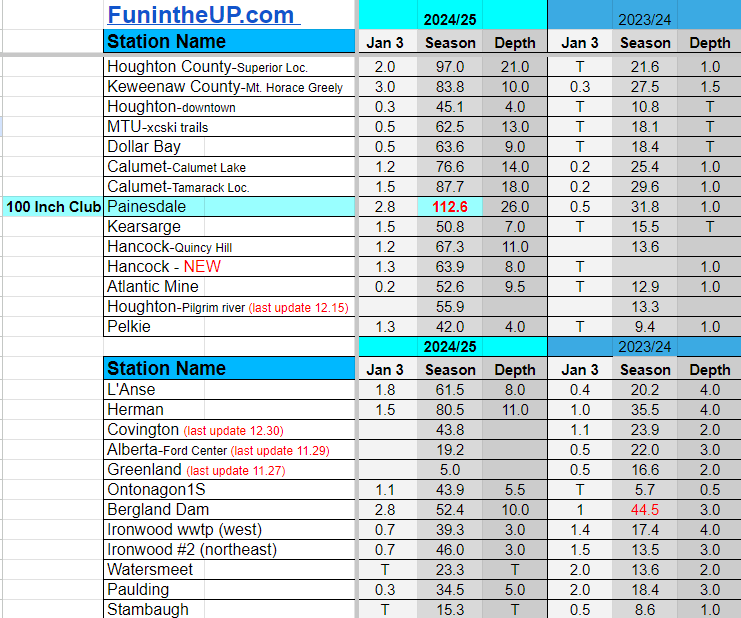
Most snowfall Jan 3: McMillan with 8.0 inches
Most snowfall, season to date: Painesdale with 112.6 inches
Biggest 24hr total this season: Soo Airport with 15.7 inches (11.30.24)
Do you enjoy FunintheUP videos and seeing the Snowfall Totals all winter? Consider supporting FunintheUP via PayPal - via Venmo
Become a monthly FunintheUP Fan Supporter
Thanks for following the UP Snow Totals page on FunintheUP.com
FunintheUP Youtube channel
TourDaYoop Youtube channel
FunintheUP on TikTok
Yooper Steve on Facebook
Yooper Steve on Instagram
FunintheUP on Instagram
If daily slot is 0" the station hasn't updated or recorded no snowfall.
Sometimes a station won't update that day and does the next day.
Tahquamenon Falls State Park only updates at the end of each month.
Keweenaw county and Houghton County Airport only update during the weekdays.
Sanderson Field Airport (Soo) updates next day.
Jan 1
NOTE: Hover cursor over images to enlarge snowfall totals.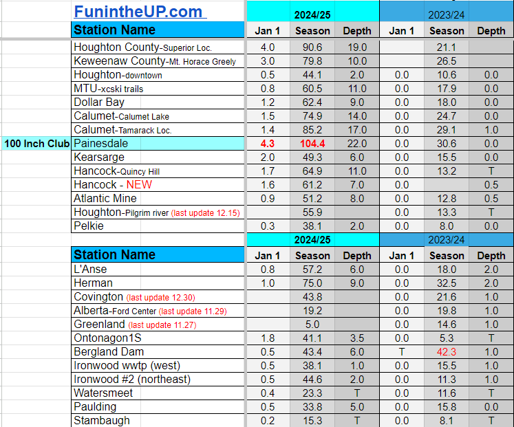

Jan 2
NOTE: Hover cursor over images to enlarge snowfall totals.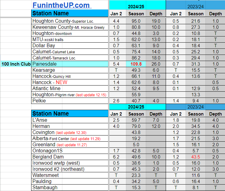
Jan 3
NOTE: Hover cursor over images to enlarge snowfall totals.