Upper Peninsula of Michigan Snowfall Totals
Winter 2024-2025
Good day to you friend, winter is here again in the Upper Peninsula, are you ready for another snowy and cold winter? Snowfall is a big part of life in the Upper Peninsula and very memorable, we Yoopers love to talk about how much snow we get each winter. This is the 15th year of snowfall reports on FunintheUP.com, thanks for following the snowfall page!
Thousands of people follow from all 50 states and people from all over the world follow FunintheUP Snowfall Reports all winter. The snowfall totals are used by snowmobilers, news stations, emergency personnel, city officials, road crews, skiers, snowboarders, groomers, ski resorts. The most snow for 2023/24 was at the Calumet Tamarack loation snow station with 173 inches of snow you can view last years snow totals here. Begin looking at the 2024/25 winter season snowfall totals below along with other snowfall data and info.
--Thank you so much for your support for over the years, Yooper Steve.
Whose woods these are I think I know. His house is in the village though. He will not see me stopping here. To watch his woods fill up with snow.
-- Robert Frost (1874-1963)
Previous Years Snowfall Totals
2023/2024 Upper Peninsula Snowfall - 2022/2023 Upper Peninsula Snowfall2021/2022 Upper Peninsula Snowfall - 2019/2020 Upper Peninsula Snowfall - 2018/2019 Upper Peninsula Snowfall
2017/2018 Upper Peninsula Snowfall - 2016/2017 Upper Peninsula Snowfall - 2014/15 Upper Peninsula Snowfall
Top 5 snowfall amounts in the Upper Peninsula.
390.4" - 1978/79 - Keweenaw county (near Delaware)
384.0" - 1996/97 - Herman
367.4" - 1995/96 - Keweenaw county (near Delaware)
362.8" - 2018/19 - Tamarack location (near Calumet)
354.1" - 1978/79 - Houghton county airport
384.0" - 1996/97 - Herman
367.4" - 1995/96 - Keweenaw county (near Delaware)
354.1" - 1978/79 - Houghton county airport
Thank you so much for your support! -- Yooper Steve I'll be doing snow updates all winter on Facebook, Instagram, TikTok, and Youtube so be sure to follow and subscribe on those socials if you aren't already.
Snow totals are updated on the website through Feb 11th and Subscribers of the Yooper Report will be emailed the Feb 15th and 16th Snow totals 2.17 later in the night.
Snowfall on Dec 31, 2024
Snowfall Reports by Yooper Steve
Daily UP Snowfall for 2024/25
Today's Notes:
Paid subscriptions on Substack allow these snowfall reports and fall color reports to continue each year. Thanks for subscribing to the Yooper Report become a subscriber to get snow totals and snowfall report/forecast emailed to you before they post here on the website.
Check out the FunintheUP Amazon Store - my recommended camping gear, winter clothing, Yooper rock hunting stuff, U.P. books worth reading
Join me on a Guided U.P. Tour to see places you’d never see on your own - UpperPeninsulaTours.com - adventures away from the crowds
Most snowfall Dec 30: Munising with 1.0 inches
Most snowfall, season to date: Painesdale with 100.1 inches
Biggest 24hr total this season: Soo Airport with 15.7 inches (11.30.24)
Do you enjoy FunintheUP videos and seeing the Snowfall Totals all winter? Consider supporting FunintheUP via PayPal - via Venmo
Become a monthly FunintheUP Fan Supporter
Thanks for following the UP Snow Totals page on FunintheUP.com
FunintheUP Youtube channel
TourDaYoop Youtube channel
FunintheUP on TikTok
Yooper Steve on Facebook
Yooper Steve on Instagram
FunintheUP on Instagram
If daily slot is 0" the station hasn't updated or recorded no snowfall.
Sometimes a station won't update that day and does the next day.
Tahquamenon Falls State Park only updates at the end of each month.
Keweenaw county and Houghton County Airport only update during the weekdays.
Sanderson Field Airport (Soo) updates next day.
Dec 31
NOTE: Hover cursor over images to enlarge snowfall totals.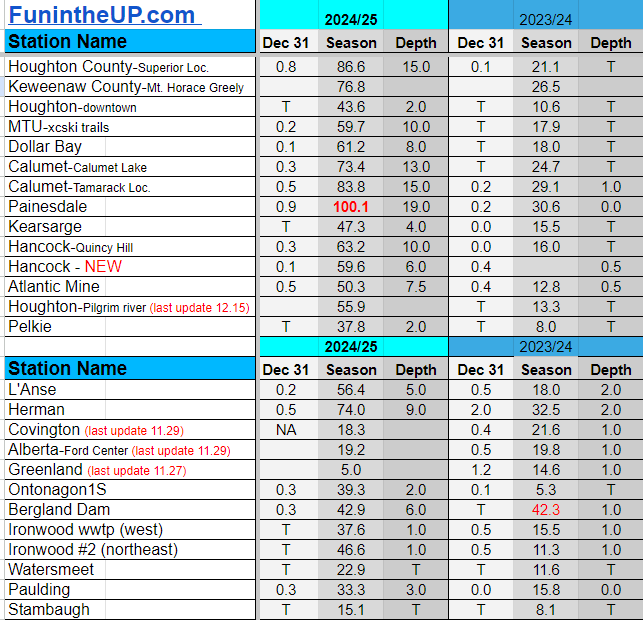


Snowfall on Dec 30, 2024
Snowfall Reports by Yooper Steve
Daily UP Snowfall for 2024/25
Today's Notes:
Lake effect snow returns and so do the colder temps, at lest through the weekend into early next week.
Paid subscriptions on Substack allow these snowfall reports and fall color reports to continue each year. Thanks for subscribing to the Yooper Report become a subscriber to get snow totals and snowfall report/forecast emailed to you before they post here on the website.
Check out the FunintheUP Amazon Store - my recommended camping gear, winter clothing, Yooper rock hunting stuff, U.P. books worth reading
Join me on a Guided U.P. Tour to see places you’d never see on your own - UpperPeninsulaTours.com - adventures away from the crowds
Most snowfall Dec 30: Herman with 1.5 inches
Most snowfall, season to date: Painesdale with 99.2 inches
Biggest 24hr total this season: Soo Airport with 15.7 inches (11.30.24)
Do you enjoy FunintheUP videos and seeing the Snowfall Totals all winter? Consider supporting FunintheUP via PayPal - via Venmo
Become a monthly FunintheUP Fan Supporter
Thanks for following the UP Snow Totals page on FunintheUP.com
FunintheUP Youtube channel
TourDaYoop Youtube channel
FunintheUP on TikTok
Yooper Steve on Facebook
Yooper Steve on Instagram
FunintheUP on Instagram
If daily slot is 0" the station hasn't updated or recorded no snowfall.
Sometimes a station won't update that day and does the next day.
Tahquamenon Falls State Park only updates at the end of each month.
Keweenaw county and Houghton County Airport only update during the weekdays.
Sanderson Field Airport (Soo) updates next day.
Dec 30
NOTE: Hover cursor over images to enlarge snowfall totals.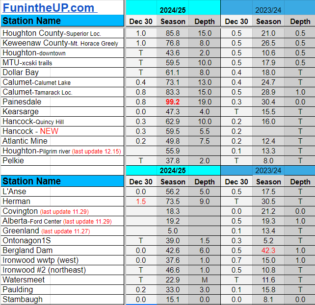
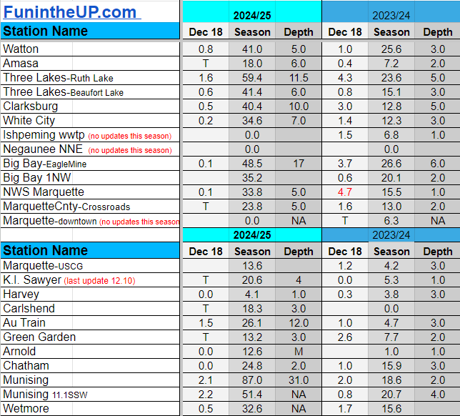
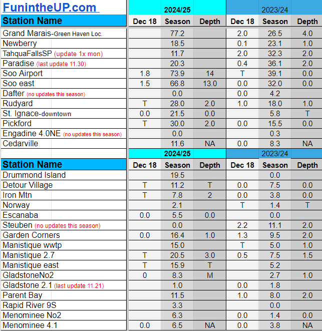
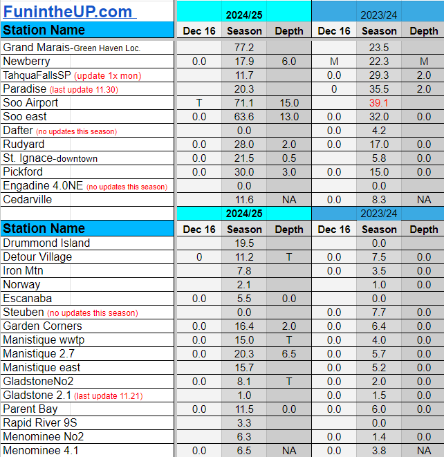
Snowfall on Dec 18, 2024
Snowfall Reports by Yooper Steve
Daily UP Snowfall for 2024/25
Today's Notes:
This post was originally posted to Subscribers on Substack before it was uploaded here on the website. Subscribers to the Yooper Report get snow forecasts and snow totals emailed to them before they are put here on the website.
After 20 straight days of measurable snowfall we had 3 days of no measurable snow. A good start to winter indeed in most places across the Upper Peninsula, except the southern areas of the Upper Peninsula, like Iron Mountain to Escanaba, to Gladstone, Manistique, and over to St. Ignace. There isn’t much if any snow on the ground and grass is showing. Meanwhile in places in the Keweenaw and right around the Munising area have 25-30 inches of snow on the ground and places around Ironwood and the Soo have 3-10 inches on the ground only.
The last couple days there hasn’t been any significant snowfall, just a couple inches, but enough to cover up some of the crusty snow and icy driveways after the warmup.
If you wanted more snow like we saw the last few weeks, you won’t be seeing it anytime soon, perhaps for another 2 weeks. You’ll have to deal with another low snow December it looks like, but it is better than last December that’s for sure.
Monday it appears a southerly wind could give the southern U.P. and far eastern U.P. a little bit of snow maybe up to 2 inches, but nothing more as the low moves out pretty quickly Monday night. The rest of the Upper Peninsula will see a mostly dry period from Sunday to into Thursday.
Above normal temperatures look to reappear Thursday bringing with it moisture from the southwest and from the Gulf giving us a chance of rain Thursday and Friday, maybe a little mixed precipitation early Thursday before temps get into the mid 30s to upper 30s.
In the next few days we may see our first snow station hit 100 inches for the season, we have a few others 20-25 inches from hitting 100 inches.
Paid subscriptions on Substack allow these snowfall reports and fall color reports to continue each year. Thanks for subscribing to the Yooper Report become a subscriber to get snow totals and snowfall report/forecast emailed to you before they post here on the website.
Check out the FunintheUP Amazon Store - my recommended camping gear, winter clothing, Yooper rock hunting stuff, U.P. books worth reading
Join me on a Guided U.P. Tour to see places you’d never see on your own - UpperPeninsulaTours.com - adventures away from the crowds
Most snowfall Dec 17: Bergland Dam with 4.5 inches
Most snowfall, season to date: Painesdale with 96.7 inches
Biggest 24hr total this season: Soo Airport with 15.7 inches (11.30.24)
Do you enjoy FunintheUP videos and seeing the Snowfall Totals all winter? Consider supporting FunintheUP via PayPal - via Venmo
Become a monthly FunintheUP Fan Supporter
Thanks for following the UP Snow Totals page on FunintheUP.com
FunintheUP Youtube channel
TourDaYoop Youtube channel
FunintheUP on TikTok
Yooper Steve on Facebook
Yooper Steve on Instagram
FunintheUP on Instagram
If daily slot is 0" the station hasn't updated or recorded no snowfall.
Sometimes a station won't update that day and does the next day.
Tahquamenon Falls State Park only updates at the end of each month.
Keweenaw county and Houghton County Airport only update during the weekdays.
Sanderson Field Airport (Soo) updates next day.
Dec 18
NOTE: Hover cursor over images to enlarge snowfall totals.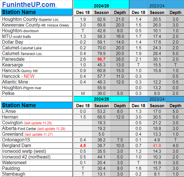
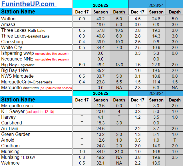
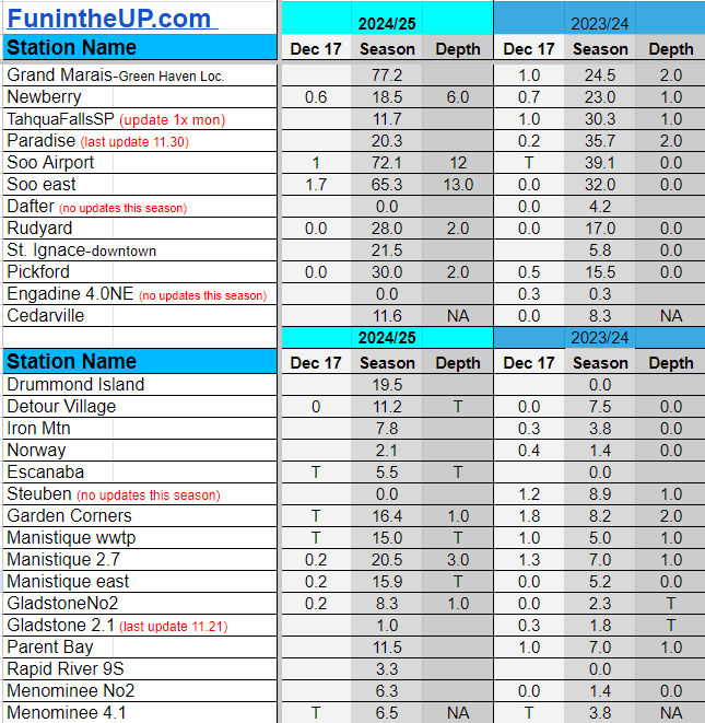
Snowfall on Dec 17, 2024
Snowfall Reports by Yooper Steve
Daily UP Snowfall for 2024/25
Today's Notes:
This post was originally posted to Subscribers on Substack before it was uploaded here on the website. Subscribers to the Yooper Report get snow forecasts and snow totals emailed to them before they are put here on the website.
After 20 straight days of measurable snowfall we had 3 days of no measurable snow. A good start to winter indeed in most places across the Upper Peninsula, except the southern areas of the Upper Peninsula, like Iron Mountain to Escanaba, to Gladstone, Manistique, and over to St. Ignace. There isn’t much if any snow on the ground and grass is showing. Meanwhile in places in the Keweenaw and right around the Munising area have 25-30 inches of snow on the ground and places around Ironwood and the Soo have 3-10 inches on the ground only.
The last couple days there hasn’t been any significant snowfall, just a couple inches, but enough to cover up some of the crusty snow and icy driveways after the warmup.
If you wanted more snow like we saw the last few weeks, you won’t be seeing it anytime soon, perhaps for another 2 weeks. You’ll have to deal with another low snow December it looks like, but it is better than last December that’s for sure.
Monday it appears a southerly wind could give the southern U.P. and far eastern U.P. a little bit of snow maybe up to 2 inches, but nothing more as the low moves out pretty quickly Monday night. The rest of the Upper Peninsula will see a mostly dry period from Sunday to into Thursday.
Above normal temperatures look to reappear Thursday bringing with it moisture from the southwest and from the Gulf giving us a chance of rain Thursday and Friday, maybe a little mixed precipitation early Thursday before temps get into the mid 30s to upper 30s.
In the next few days we may see our first snow station hit 100 inches for the season, we have a few others 20-25 inches from hitting 100 inches.
Paid subscriptions on Substack allow these snowfall reports and fall color reports to continue each year. Thanks for subscribing to the Yooper Report become a subscriber to get snow totals and snowfall report/forecast emailed to you before they post here on the website.
Check out the FunintheUP Amazon Store - my recommended camping gear, winter clothing, Yooper rock hunting stuff, U.P. books worth reading
Join me on a Guided U.P. Tour to see places you’d never see on your own - UpperPeninsulaTours.com - adventures away from the crowds
Most snowfall Dec 17: Big Bay (EagleMine) with 6.0 inches
Most snowfall, season to date: Painesdale with 94.1 inches
Biggest 24hr total this season: Soo Airport with 15.7 inches (11.30.24)
Do you enjoy FunintheUP videos and seeing the Snowfall Totals all winter? Consider supporting FunintheUP via PayPal - via Venmo
Become a monthly FunintheUP Fan Supporter
Thanks for following the UP Snow Totals page on FunintheUP.com
FunintheUP Youtube channel
TourDaYoop Youtube channel
FunintheUP on TikTok
Yooper Steve on Facebook
Yooper Steve on Instagram
FunintheUP on Instagram
If daily slot is 0" the station hasn't updated or recorded no snowfall.
Sometimes a station won't update that day and does the next day.
Tahquamenon Falls State Park only updates at the end of each month.
Keweenaw county and Houghton County Airport only update during the weekdays.
Sanderson Field Airport (Soo) updates next day.
Dec 17
NOTE: Hover cursor over images to enlarge snowfall totals.
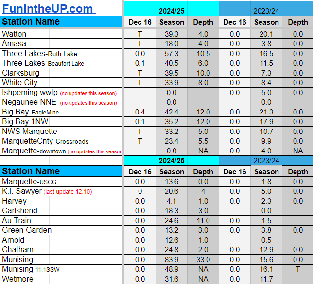
Snowfall on Dec 16, 2024
Snowfall Reports by Yooper Steve
Daily UP Snowfall for 2024/25
Today's Notes:
This post was originally posted to Subscribers on Substack before it was uploaded here on the website. Subscribers to the Yooper Report get snow forecasts and snow totals emailed to them before they are put here on the website.
After 20 straight days of measurable snowfall we had 3 days of no measurable snow. A good start to winter indeed in most places across the Upper Peninsula, except the southern areas of the Upper Peninsula, like Iron Mountain to Escanaba, to Gladstone, Manistique, and over to St. Ignace. There isn’t much if any snow on the ground and grass is showing. Meanwhile in places in the Keweenaw and right around the Munising area have 25-30 inches of snow on the ground and places around Ironwood and the Soo have 3-10 inches on the ground only.
The last couple days there hasn’t been any significant snowfall, just a couple inches, but enough to cover up some of the crusty snow and icy driveways after the warmup.
If you wanted more snow like we saw the last few weeks, you won’t be seeing it anytime soon, perhaps for another 2 weeks. You’ll have to deal with another low snow December it looks like, but it is better than last December that’s for sure.
Monday it appears a southerly wind could give the southern U.P. and far eastern U.P. a little bit of snow maybe up to 2 inches, but nothing more as the low moves out pretty quickly Monday night. The rest of the Upper Peninsula will see a mostly dry period from Sunday to into Thursday.
Above normal temperatures look to reappear Thursday bringing with it moisture from the southwest and from the Gulf giving us a chance of rain Thursday and Friday, maybe a little mixed precipitation early Thursday before temps get into the mid 30s to upper 30s.
In the next few days we may see our first snow station hit 100 inches for the season, we have a few others 20-25 inches from hitting 100 inches.
Paid subscriptions on Substack allow these snowfall reports and fall color reports to continue each year. Thanks for subscribing to the Yooper Report become a subscriber to get snow totals and snowfall report/forecast emailed to you before they post here on the website.
Check out the FunintheUP Amazon Store - my recommended camping gear, winter clothing, Yooper rock hunting stuff, U.P. books worth reading
Join me on a Guided U.P. Tour to see places you’d never see on your own - UpperPeninsulaTours.com - adventures away from the crowds
Most snowfall Dec 16: Painesdale and Calumet/Tamarack loc with 0.8 inches
Most snowfall, season to date: Painesdale with 91.9 inches
Biggest 24hr total this season: Soo Airport with 15.7 inches (11.30.24)
Do you enjoy FunintheUP videos and seeing the Snowfall Totals all winter? Consider supporting FunintheUP via PayPal - via Venmo
Become a monthly FunintheUP Fan Supporter
Thanks for following the UP Snow Totals page on FunintheUP.com
FunintheUP Youtube channel
TourDaYoop Youtube channel
FunintheUP on TikTok
Yooper Steve on Facebook
Yooper Steve on Instagram
FunintheUP on Instagram
If daily slot is 0" the station hasn't updated or recorded no snowfall.
Sometimes a station won't update that day and does the next day.
Tahquamenon Falls State Park only updates at the end of each month.
Keweenaw county and Houghton County Airport only update during the weekdays.
Sanderson Field Airport (Soo) updates next day.
Dec 16
NOTE: Hover cursor over images to enlarge snowfall totals.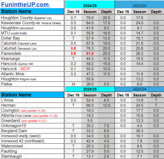
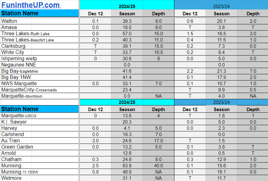
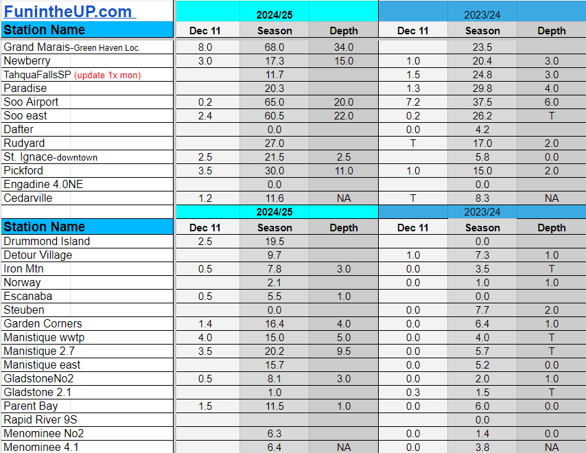
Snowfall on Dec 12, 2024
Snowfall Reports by Yooper Steve
Daily UP Snowfall for 2024/25
Today's Notes:
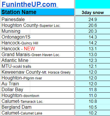
I have included the 3 day snow totals as well just below the daily snow for Dec 12th. The only areas to really experience the snowstorm effects were areas south of Houghton and just east of Munising and just west of Munising. Other areas of the UP really didn't have snowstorm conditions but some still saw a few inches of snow while others saw almost nothing.
Paid subscriptions on Substack allow these snowfall reports and fall color reports to continue each year. Thanks for subscribing to the Yooper Report become a subscriber to get snow totals and snowfall report/forecast emailed to you before they post here on the website.
Check out the FunintheUP Amazon Store - my recommended camping gear, winter clothing, Yooper rock hunting stuff, U.P. books worth reading
Join me on a Guided U.P. Tour to see places you’d never see on your own - UpperPeninsulaTours.com - adventures away from the crowds
Most snowfall Dec 12: Painesdale with 6.2 inches
Most snowfall, season to date: Painesdale with 91.1 inches
Biggest 24hr total this season: Soo Airport with 15.7 inches (11.30.24)
Do you enjoy FunintheUP videos and seeing the Snowfall Totals all winter? Consider supporting FunintheUP via PayPal - via Venmo
Become a monthly FunintheUP Fan Supporter
Thanks for following the UP Snow Totals page on FunintheUP.com
FunintheUP Youtube channel
TourDaYoop Youtube channel
FunintheUP on TikTok
Yooper Steve on Facebook
Yooper Steve on Instagram
FunintheUP on Instagram
If daily slot is 0" the station hasn't updated or recorded no snowfall.
Sometimes a station won't update that day and does the next day.
Tahquamenon Falls State Park only updates at the end of each month.
Keweenaw county and Houghton County Airport only update during the weekdays.
Sanderson Field Airport (Soo) updates next day.
Dec 12
NOTE: Hover cursor over images to enlarge snowfall totals.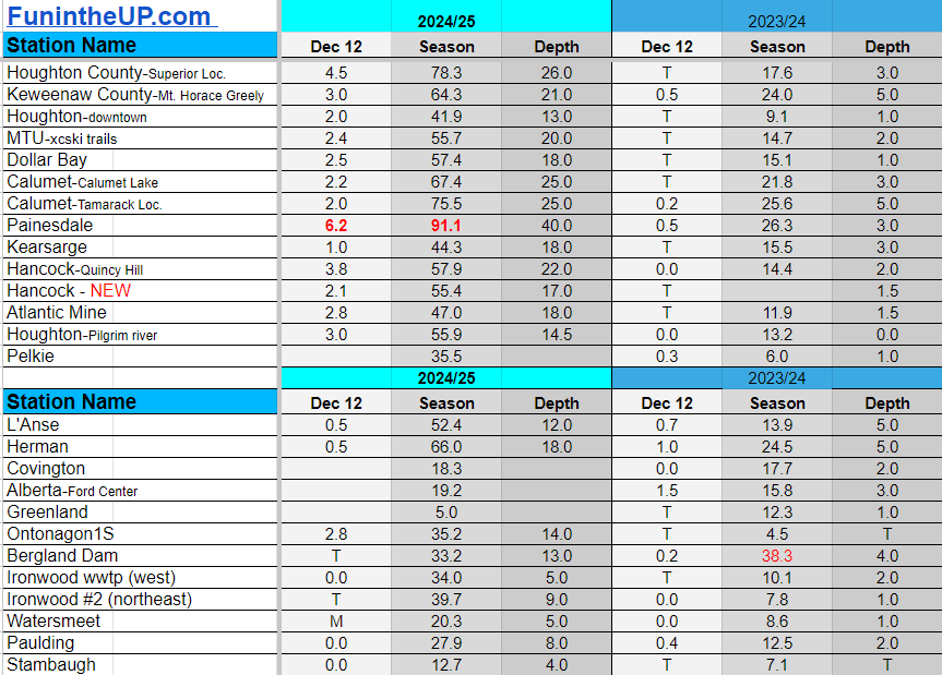

3 Day Snow Totals Dec 10-12th
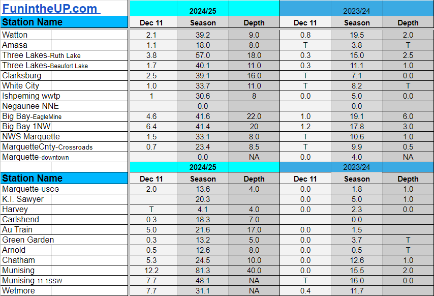
Snowfall on Dec 11, 2024
Snowfall Reports by Yooper Steve
Daily UP Snowfall for 2024/25
Today's Notes:
Paid subscriptions allow these snowfall reports and fall color reports to continue each year. Thanks for subscribing to the Yooper Report become a subscriber to get snow totals and snowfall report/forecast emailed to you before they post here on the website.
Check out the FunintheUP Amazon Store - my recommended camping gear, winter clothing, Yooper rock hunting stuff, U.P. books worth reading
Join me on a Guided U.P. Tour to see places you’d never see on your own - UpperPeninsulaTours.com - adventures away from the crowds
Most snowfall Dec 11: Painesdale with 12.5 inches
Most snowfall, season to date: Painesdale with 84.9 inches
Biggest 24hr total this season: Soo Airport with 15.7 inches (11.30.24)
Do you enjoy FunintheUP videos and seeing the Snowfall Totals all winter? Consider supporting FunintheUP via PayPal - via Venmo
Become a monthly FunintheUP Fan Supporter
Thanks for following the UP Snow Totals page on FunintheUP.com
FunintheUP Youtube channel
TourDaYoop Youtube channel
FunintheUP on TikTok
Yooper Steve on Facebook
Yooper Steve on Instagram
FunintheUP on Instagram
If daily slot is 0" the station hasn't updated or recorded no snowfall.
Sometimes a station won't update that day and does the next day.
Tahquamenon Falls State Park only updates at the end of each month.
Keweenaw county and Houghton County Airport only update during the weekdays.
Sanderson Field Airport (Soo) updates next day.
Dec 11
NOTE: Hover cursor over images to enlarge snowfall totals.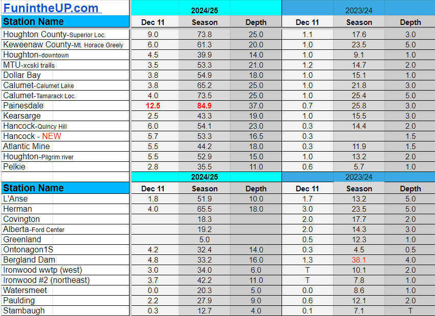
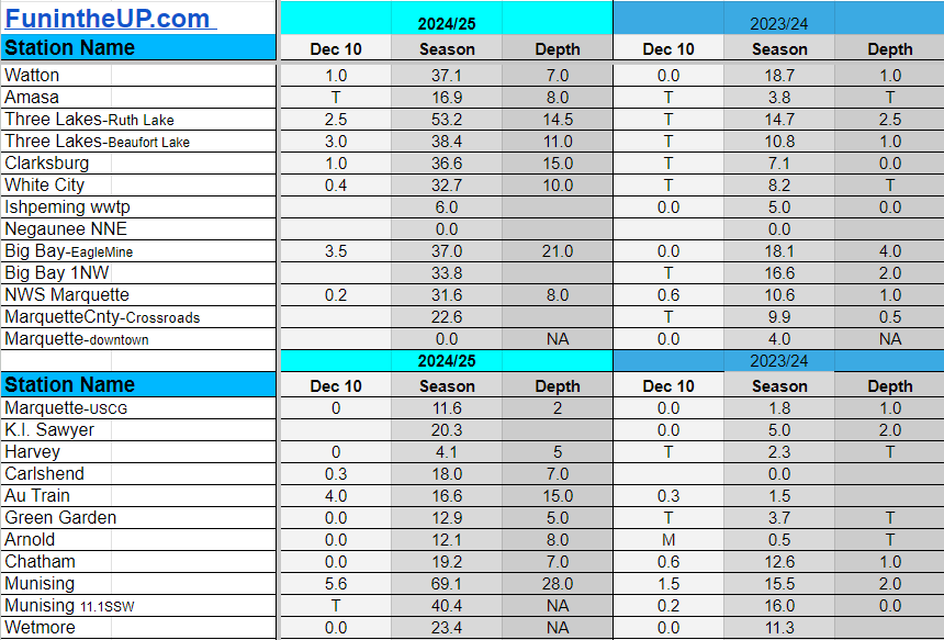
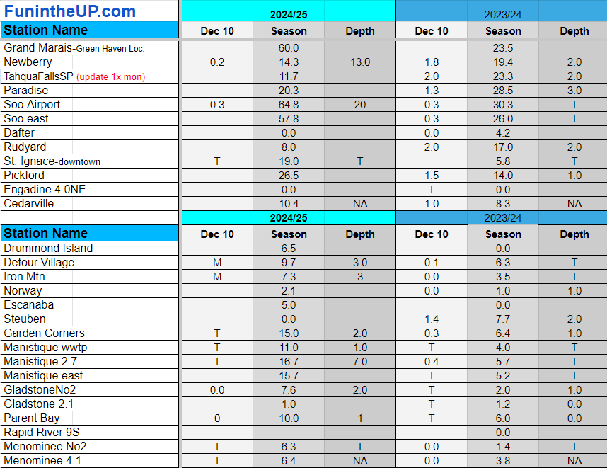
Snowfall on Dec 10, 2024
Snowfall Reports by Yooper Steve
Daily UP Snowfall for 2024/25
Today's Notes:
NEWS:
UP Snowmobile Trail Re-route in Wakefield per Gogebic Range Trail Authority - ORV & Snowmobile Club “trail 8 park and ride in Wakefield to the east is now closed because a land owner pulled the use permit”. “We are currently working on a re route through the city of Wakefield. More information will be announced as soon as possible!”
11:45pm(12.11.24) Road Closure due to blowing snow M95 to M77 (Seney Stretch)
1:35am (12.12.24) Road closure due to blowing snow M95 Shingleton to Manistique
Marquette Mountain Ski hill opens today.
Winter is off to a good start
This winter is certainly on a track to become one to remember for years to come. There is a lot of winter to be had yet, so hold on tight, with cool Arctic air, Lake Superior, and a few wrenches thrown in we could be in for a doozy, good for some, maybe not so delightful for others.I myself love a good snowstorm and a winter to remember. Winter is magical and it’s what makes the Upper Peninsula the U.P. we love so much, without winter it just wouldn’t be the same. I do understand how some say, “keep it up there”, “you can have it”, “pretty to look at, but not for me”, I do understand, but I don’t fully understand, at least not yet. I haven’t found a winter I didn’t like, even last year with our lack of snow, I still found it beautiful and enjoyable, even with the lack of that white gold.
So far most if not all snow stations in the Upper Peninsula are ahead of last season snow totals as of now and it appears that it might stay that way for most of them until the last snowflake falls in April or May.
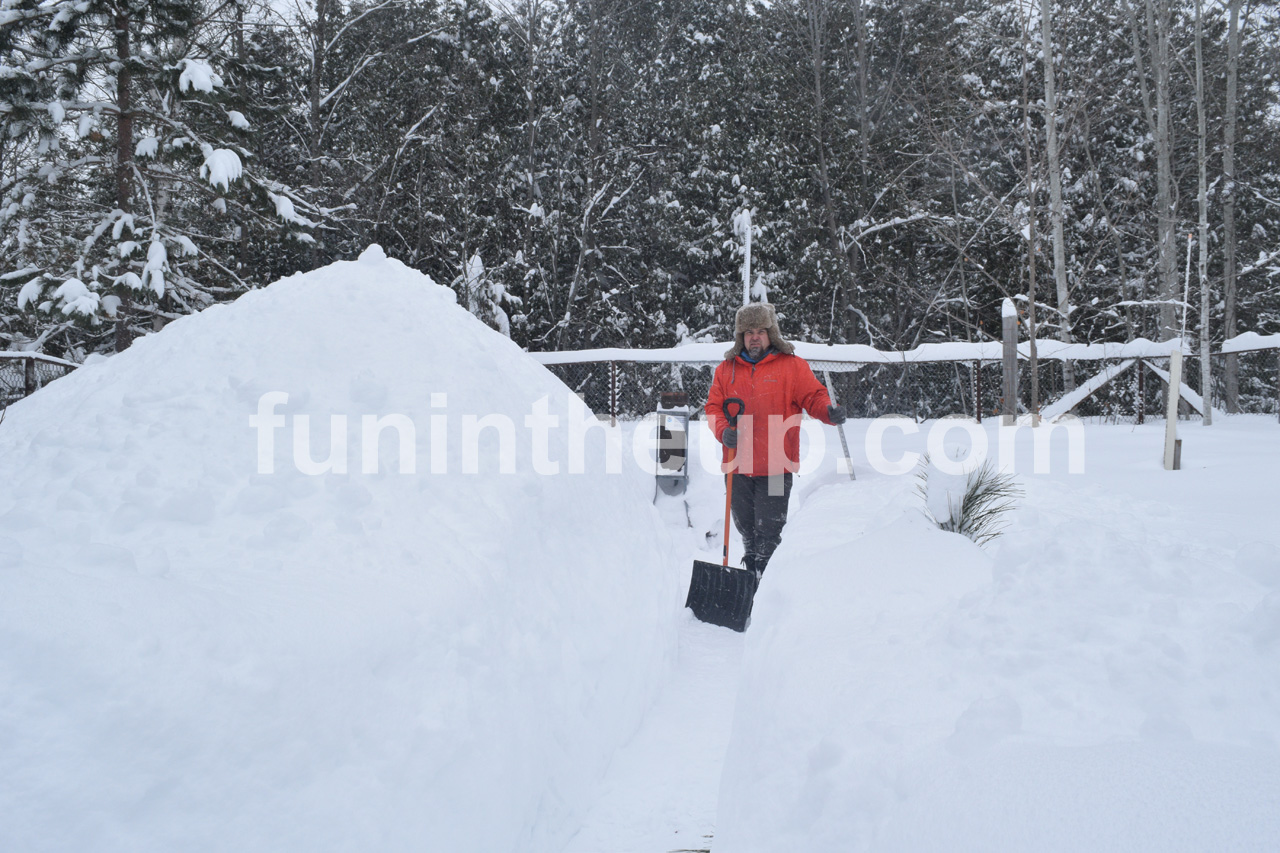
Today’s measurable snow was super light and easy to shovel it was like lifting air, I think, I haven’t lifted air before so I really wouldn’t know, but I know it was light, much lighter than the snow we saw a few days ago.
I drove through the heaviest snowfall I’ve seen for about 4 years here in the U.P. I was going to drive up to Toivola for a LIVE drive on facebook but I only got a few miles outside of Painesdale before I decided to turn back, snow was just to heavy and I didn’t have a purpose other than to show how much snow was out in Toivola. I decided it was safer to just turn around, plus you really couldn’t see much of anything as well. To watch the video you can watch it here.
I am hoping that tomorrow if time allows I will be able to get up to the Twin Lakes and Toivola area to do a LIVE video on facebook.
Tomorrow should have some good snow totals. The snowbands are slamming the Keweenaw and Munising area tonight. Let’s just hope there isn’t much of a warmup early next week and we don’t see rain which is expected Monday before it cools off again Tuesday with another lake effect snow blast starting Wednesday.
Paid subscriptions allow these snowfall reports and fall color reports to continue each year. Thanks for subscribing to the Yooper Report become a subscriber to get snow totals and snowfall report/forecast emailed to you before they post here on the website.
Check out the FunintheUP Amazon Store - my recommended camping gear, winter clothing, Yooper rock hunting stuff, U.P. books worth reading
Join me on a Guided U.P. Tour to see places you’d never see on your own - UpperPeninsulaTours.com - adventures away from the crowds
Most snowfall Dec 10: Ontonagon with 7.3 inches
Most snowfall, season to date: Painesdale with 72.4 inches
Biggest 24hr total this season: Soo Airport with 15.7 inches (11.30.24)
Do you enjoy FunintheUP videos and seeing the Snowfall Totals all winter? Consider supporting FunintheUP via PayPal - via Venmo
Become a monthly FunintheUP Fan Supporter
Thanks for following the UP Snow Totals page on FunintheUP.com
FunintheUP Youtube channel TourDaYoop Youtube channel FunintheUP on TikTok Yooper Steve on Facebook
Yooper Steve on Instagram
FunintheUP on Instagram
If daily slot is 0" the station hasn't updated or recorded no snowfall.
Sometimes a station won't update that day and does the next day.
Tahquamenon Falls State Park only updates at the end of each month.
Keweenaw county and Houghton County Airport only update during the weekdays.
Sanderson Field Airport (Soo) updates next day.
Dec 10
NOTE: Hover cursor over images to enlarge snowfall totals.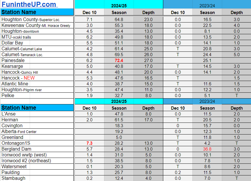
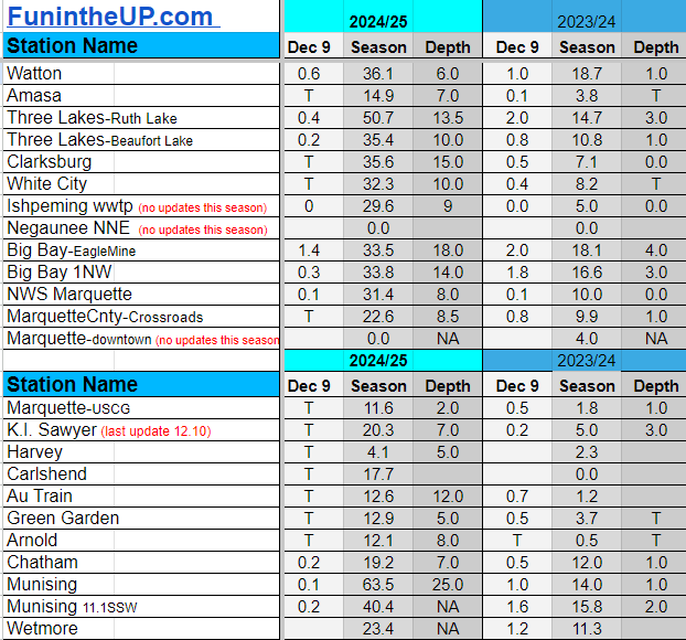
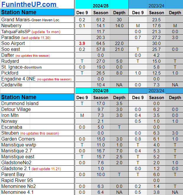
Snowfall on Dec 9, 2024
Snowfall Reports by Yooper Steve
Daily UP Snowfall for 2024/25
Today's Notes:
Loved how the snow was clinging to the tree branches today after a little light rain froze last night and some light fluffy snow accumulated across the Keweenaw.
Just going to post the snow totals for today and not do much of a write up today. Just another day of some light snow a lot fluffier than the previous day. Today things were really crusty and snow that was soft yesterday got hardened so if you didn’t clean up your driveway with all the soft slushy snow you really had a mess to deal with.
Most snowfall happened where I was saying it would in yesterday’s update around the Keweenaw, a few areas in Marquette county and over by the Soo. Other places only saw a trace to a few tenths of an inch many no snow accumulations at all.
Some places down off of Lake Michigan shoreline don’t even have any snow on the ground, but perhaps these strong NW and N winds will be able to drive down a little left over lake effect snowfall.
We should see some strong lake effect snow bands through the Keweenaw from Painesdale to Calumet, the Michigamme highlands, and Marquette county and Alger county line to Shingleton area, even over towards H77.
Paid subscriptions allow these snowfall reports and fall color reports to continue each year. Thanks for subscribing to the Yooper Report become a subscriber to get snow totals and snowfall report/forecast emailed to you before they post here on the website.
Check out the FunintheUP Amazon Store - my recommended camping gear, winter clothing, Yooper rock hunting stuff, U.P. books worth reading
Join me on a Guided U.P. Tour to see places you’d never see on your own - UpperPeninsulaTours.com - adventures away from the crowds
Most snowfall Dec 9: Soo Airport with 3.9 inches
Most snowfall, season to date: Painesdale with 66.2 inches
Biggest 24hr total this season: Soo Airport with 15.7 inches (11.30.24)
Do you enjoy FunintheUP videos and seeing the Snowfall Totals all winter? Consider supporting FunintheUP via PayPal - via Venmo
Become a monthly FunintheUP Fan Supporter
Thanks for following the UP Snow Totals page on FunintheUP.com
FunintheUP Youtube channel
TourDaYoop Youtube channel
FunintheUP on TikTok
Yooper Steve on Facebook
Yooper Steve on Instagram
FunintheUP on Instagram
If daily slot is 0" the station hasn't updated or recorded no snowfall.
Sometimes a station won't update that day and does the next day.
Tahquamenon Falls State Park only updates at the end of each month.
Keweenaw county and Houghton County Airport only update during the weekdays.
Sanderson Field Airport (Soo) updates next day.
Dec 9
NOTE: Hover cursor over images to enlarge snowfall totals.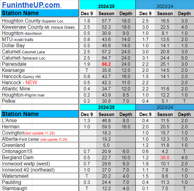
Snowfall on Dec 8, 2024
Snowfall Reports by Yooper Steve
Daily UP Snowfall for 2024/25
Today's Notes:
Another storm coming Wednesday
After a warmer day on Sunday we saw some snow and rain move into the Upper Peninsula in the evening hours and early morning Monday. Snow eventually made way to light rain and temperature increases that quickly made backroads soft and mushy, work crews were out getting the mess cleaned up pretty quickly by late morning.
We should have a day of light snowfall across the northern half of the Upper Peninsula on Tuesday but it is a different story come Wednesday when some brisk NW winds move in which should bring some nice heavy lake effect snow across the NW snowbelts. Heavier snowfall looks to be in the upper elevations from Twin lakes to Calumet, upper regions of western Marquette county, and just east of Munising.
Winter Storm Watch has been issued for
Gogebic and Ontonagon counties starting at midnight CST, and for
Houghton, Baraga, and Keweenaw counties starting at 7 AM EST.
Snowfall is expected to exceed one inch per hour in the heaviest
bands late Tuesday to late Wednesday.
Temperatures will stick around the mid 20s Tuesday and into Wednesday with a dip into the teens and some possible single digits by Thursday night into early Friday morning. Don’t expect temperatures to stay cool long but returning to above normal late weekend which could make things a little mushy once again.
Snowmobile clubs took the day off from grooming as the conditions weren’t ripe for grooming with the rain and warmer temps making for some mushy conditions along with some exposed water holes and also some rock and bare dirt has been exposed as a result of that. With the snowstorm coming Wednesday it should help cover up some of the barespots, also the cold temps Thursday and Friday should help a bit. I am just hoping that they stay in decent condition over the weekend into early next week as temps might creep back up above freezing again.
Paid subscriptions allow these snowfall reports and fall color reports to continue each year. Thanks for subscribing to the Yooper Report become a subscriber to get snow totals and snowfall report/forecast emailed to you before they post here on the website.
Check out the FunintheUP Amazon Store - my recommended camping gear, winter clothing, Yooper rock hunting stuff, U.P. books worth reading
Join me on a Guided U.P. Tour to see places you’d never see on your own - UpperPeninsulaTours.com - adventures away from the crowds
Most snowfall Dec 8: Painesdale with 6.5 inches
Most snowfall, season to date: Painesdale with 64.3 inches
Biggest 24hr total this season: Soo Airport with 15.7 inches (11.30.24)
Do you enjoy FunintheUP videos and seeing the Snowfall Totals all winter? Consider supporting FunintheUP via PayPal - via Venmo
Become a monthly FunintheUP Fan Supporter
Thanks for following the UP Snow Totals page on FunintheUP.com
FunintheUP Youtube channel
TourDaYoop Youtube channel
FunintheUP on TikTok
Yooper Steve on Facebook
Yooper Steve on Instagram
FunintheUP on Instagram
If daily slot is 0" the station hasn't updated or recorded no snowfall.
Sometimes a station won't update that day and does the next day.
Tahquamenon Falls State Park only updates at the end of each month.
Keweenaw county and Houghton County Airport only update during the weekdays.
Sanderson Field Airport (Soo) updates next day.
Dec 8
NOTE: Hover cursor over images to enlarge snowfall totals.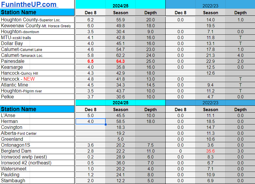
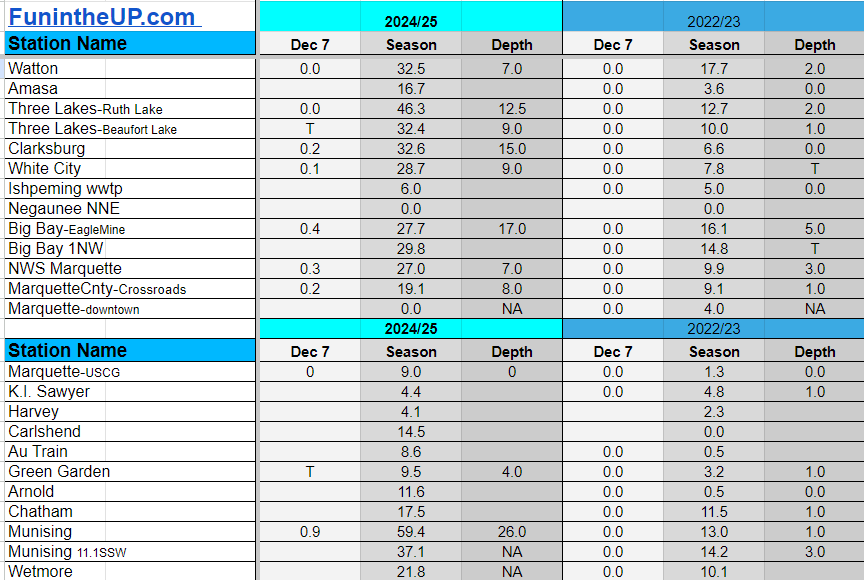
Snowfall on Dec 7, 2024
Snowfall Reports by Yooper Steve
Daily UP Snowfall for 2024/25
Today's Notes:
Below you'll find the snow totals for Dec 7th.
Be sure to check out the Yooper Steve Amazon Store for my recommended products
Most snowfall Dec 7: Soo Airport with 6.9 inches
Most snowfall, season to date: Soo Airport with 59.9 inches
Biggest 24hr total this season: Soo Airport with 15.7 inches (11.30.24)
Do you enjoy FunintheUP videos and seeing the Snowfall Totals all winter? Consider supporting FunintheUP via PayPal - via Venmo
Become a monthly FunintheUP Fan Supporter
Thanks for following the UP Snow Totals page on FunintheUP.com
FunintheUP Youtube channel
TourDaYoop Youtube channel
FunintheUP on TikTok
Yooper Steve on Facebook
Yooper Steve on Instagram
FunintheUP on Instagram
If daily slot is 0" the station hasn't updated or recorded no snowfall.
Sometimes a station won't update that day and does the next day.
Tahquamenon Falls State Park only updates at the end of each month.
Keweenaw county and Houghton County Airport only update during the weekdays.
Sanderson Field Airport (Soo) updates next day.
Dec 7
NOTE: Hover cursor over images to enlarge snowfall totals.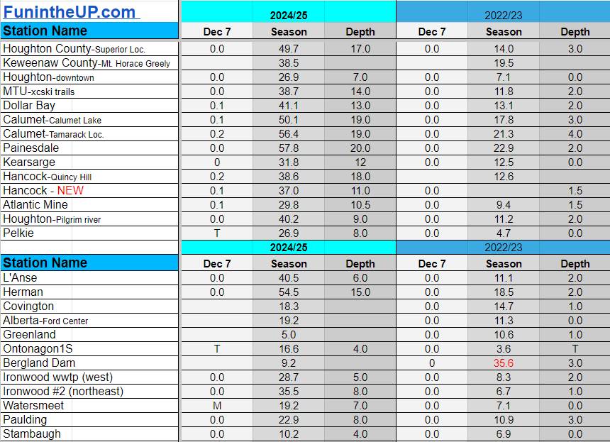

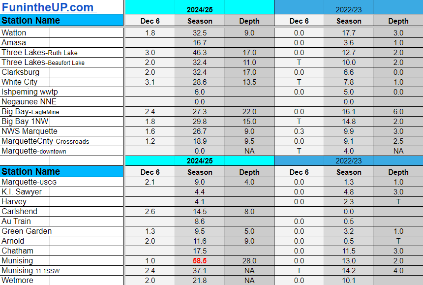
Snowfall on Dec 6, 2024
Snowfall Reports by Yooper Steve
Daily UP Snowfall for 2024/25
Today's Notes:
Below you'll find the snow totals for Dec 6th.
Be sure to check out the Yooper Steve Amazon Store for my recommended products
Most snowfall Dec 6: Herman and Pickford both with 4 inches
Most snowfall, season to date: Munising with 58.5 inches
Biggest 24hr total this season: Soo Airport with 15.7 inches (11.30.24)
Do you enjoy FunintheUP videos and seeing the Snowfall Totals all winter? Consider supporting FunintheUP via PayPal - via Venmo
Become a monthly FunintheUP Fan Supporter
Thanks for following the UP Snow Totals page on FunintheUP.com
FunintheUP Youtube channel
TourDaYoop Youtube channel
FunintheUP on TikTok
Yooper Steve on Facebook
Yooper Steve on Instagram
FunintheUP on Instagram
If daily slot is 0" the station hasn't updated or recorded no snowfall.
Sometimes a station won't update that day and does the next day.
Tahquamenon Falls State Park only updates at the end of each month.
Keweenaw county and Houghton County Airport only update during the weekdays.
Sanderson Field Airport (Soo) updates next day.
Dec 6
NOTE: Hover cursor over images to enlarge snowfall totals.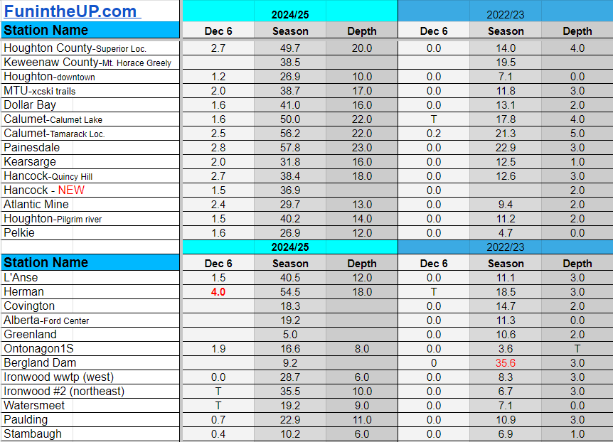

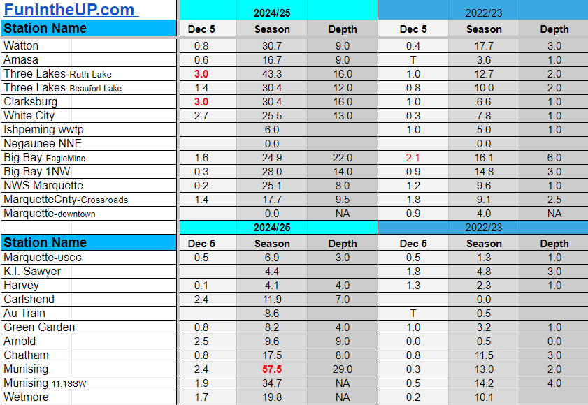
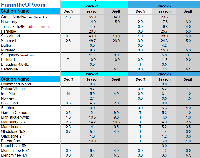
Snowfall on Dec 5, 2024
Snowfall Reports by Yooper Steve
Daily UP Snowfall for 2024/25
Today's Notes:
Below you'll find the snow totals for Dec 5th.
Be sure to check out the Yooper Steve Amazon Store for my recommended products
Most snowfall Dec 5: Clarksburg and Three Lakes (RuthLake) both with 3 inches
Most snowfall, season to date: Painesdale with 57.5 inches
Biggest 24hr total this season: Soo Airport with 15.7 inches (11.30.24)
Do you enjoy FunintheUP videos and seeing the Snowfall Totals all winter? Consider supporting FunintheUP via PayPal - via Venmo
Become a monthly FunintheUP Fan Supporter
Thanks for following the UP Snow Totals page on FunintheUP.com
FunintheUP Youtube channel
TourDaYoop Youtube channel
FunintheUP on TikTok
Yooper Steve on Facebook
Yooper Steve on Instagram
FunintheUP on Instagram
If daily slot is 0" the station hasn't updated or recorded no snowfall.
Sometimes a station won't update that day and does the next day.
Tahquamenon Falls State Park only updates at the end of each month.
Keweenaw county and Houghton County Airport only update during the weekdays.
Sanderson Field Airport (Soo) updates next day.
Dec 5
NOTE: Hover cursor over images to enlarge snowfall totals.
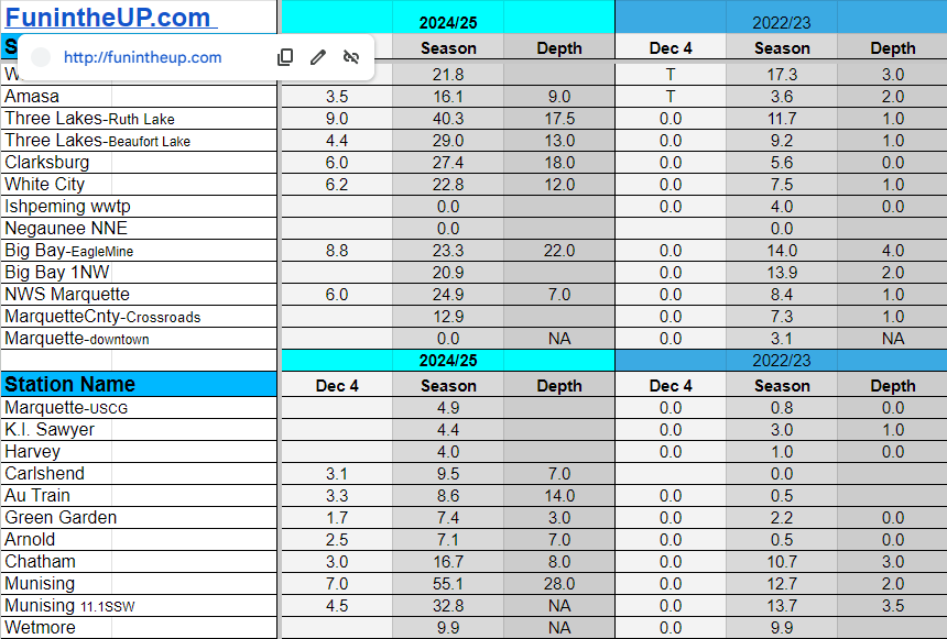
Snowfall on Dec 4, 2024
Snowfall Reports by Yooper Steve
Daily UP Snowfall for 2024/25
Today's Notes:
Half way to 100 inches
Well that happened pretty fast, we’ve hit 50+ inches of snow at a handful of weather stations today. Even though many stations saw their first snowfall around Halloween it wasn’t until around the middle of November when we started seeing a few more inches and it wasn’t until this past week that we really saw the landscape looking like winter was here to stay.After a windy and cold day yesterday it was nice to have a day of calm winds and some a few rays of sunshine with some blue skies about mid afternoon.
Warmup coming
This coming weekend we will see temperatures getting into the upper 30s and possibly touching the low 40s Sunday and Monday, even a chance of rain.I saw a few people on rooftops around the Houghton and Calumet area today shoveling roofs off, with all the snow and winds it has gotten a little thick up on some roofs and with the warmup coming it is a good idea to get them shoveled off. If you don’t keep up on the snow on the roofs it could lead to a roof collapse especially when we see heavier wet snow and then warmer temps which adds moisture to the snow, then freezes, bad things can happen.
Snowmobile trails are pretty thin yet, around the Keweenaw in Houghton, Hancock, and Calumet I’ve measured trail depth from 6 inches in Houghton along trail 3, Hancock trail 17 was 5-8 inches deep, and 7-9 inches deep on trail 17 near Swedetown and also by Calumet Lake.
There are a lot of wet spots across the snowmobile trails as the ground is still wet and what ice has formed is very thin yet, some places are muddy too with sleds going over them. Overall conditions are early season riding with hazards but rideable especially areas north of M28 across the Upper Peninsula.
Be sure to check out the Yooper Steve Amazon Store for my recommended products
Most snowfall Dec 4: Herman with 11 inches
Most snowfall, season to date: Painesdale with 53.5 inches
Biggest 24hr total this season: Soo Airport with 15.7 inches (11.30.24)
Do you enjoy FunintheUP videos and seeing the Snowfall Totals all winter? Consider supporting FunintheUP via PayPal - via Venmo
Become a monthly FunintheUP Fan Supporter
Thanks for following the UP Snow Totals page on FunintheUP.com
FunintheUP Youtube channel TourDaYoop Youtube channel FunintheUP on TikTok Yooper Steve on Facebook
Yooper Steve on Instagram
FunintheUP on Instagram
If daily slot is 0" the station hasn't updated or recorded no snowfall.
Sometimes a station won't update that day and does the next day.
Tahquamenon Falls State Park only updates at the end of each month.
Keweenaw county and Houghton County Airport only update during the weekdays.
Sanderson Field Airport (Soo) updates next day.
Dec 4
NOTE: Hover cursor over images to enlarge snowfall totals.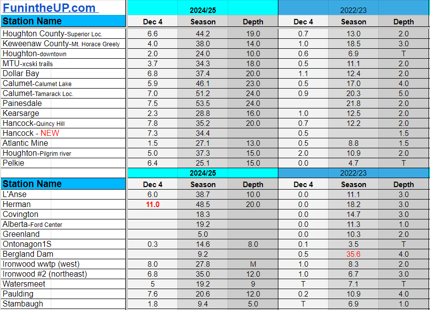

Snowfall on Dec 3, 2024
Snowfall Reports by Yooper Steve
Daily UP Snowfall for 2024/25
Today's Notes:
More snow, are you sick of it yet? Not me, I enjoy a good snowstorm and extreme winter conditions, I think that should be evident to most if you have been following my winter videos for the last 12 years. I look forward to winter like a lot of other winter enthusiasts, there is just something special about a good snowstorm and whiteout conditions that you just can’t explain to someone who has never experienced a good snowstorm. Our snowstorms here in the U.P. are pretty small and uneventful compared to places out west, but certain areas of the U.P. can hold their own.
The Keweenaw is almost always one of the snowiest places east of the Rockies in the lower 48. Imagine for a moment what life was like back many thousands of years when the Huron Mountains and the tip of the Keweenaw had some of the tallest mountains in the world, what kind of snow amounts did they see? I can’t even begin to imagine myself, but it would have been fun to experience, well maybe.
This last week brought us some good snow totals to start off the winter and tonight continues more rounds of lake effect after a couple days of calm winds and very light snow flurries.
Overnight there was a bit of freezing drizzle that made the roadways pretty slick and left a nice sheet of ice on top of the freshly fallen snow. The freezing drizzle left the trees and an object that was exposed outdoors with a layer of ice on it. With the wind blowing the tree branches around in the woods it was like thousands of wind chimes blowing around as the icy branches hit each other.
I want to write some more but I am getting tired sitting here at 130am. I have some videos and pictures I want to post for you to see from earlier today so may make a separate post on that After measuring snow and doing snow removal today I went sledding with a friend and then we took some wind measurements in the Keweenaw at a couple spots.
The lake effect snow banding can be seen tonight slamming parts of Marquette, Alger, and Schoolcraft counties. Unfortunately radar doesn’t pick up lake effect snow bands in much of Baraga, any of Houghton or Keweenaw, and much of Ontonagon county.
Be sure to check out the Yooper Steve Amazon Store for my recommended products
Most snowfall Dec 3: Herman with 8.3 inches
Most snowfall, season to date: Grand Marais with 47.5 inches
Biggest 24hr total this season: Soo Airport with 15.7 inches (11.30.24)
Do you enjoy FunintheUP videos and seeing the Snowfall Totals all winter? Consider supporting FunintheUP via PayPal - via Venmo
Become a monthly FunintheUP Fan Supporter
Thanks for following the UP Snow Totals page on FunintheUP.com
FunintheUP Youtube channel
TourDaYoop Youtube channel
FunintheUP on TikTok
Yooper Steve on Facebook
Yooper Steve on Instagram
FunintheUP on Instagram
If daily slot is 0" the station hasn't updated or recorded no snowfall.
Sometimes a station won't update that day and does the next day.
Tahquamenon Falls State Park only updates at the end of each month.
Keweenaw county and Houghton County Airport only update during the weekdays.
Sanderson Field Airport (Soo) updates next day.
Dec 3
NOTE: Hover cursor over images to enlarge snowfall totals.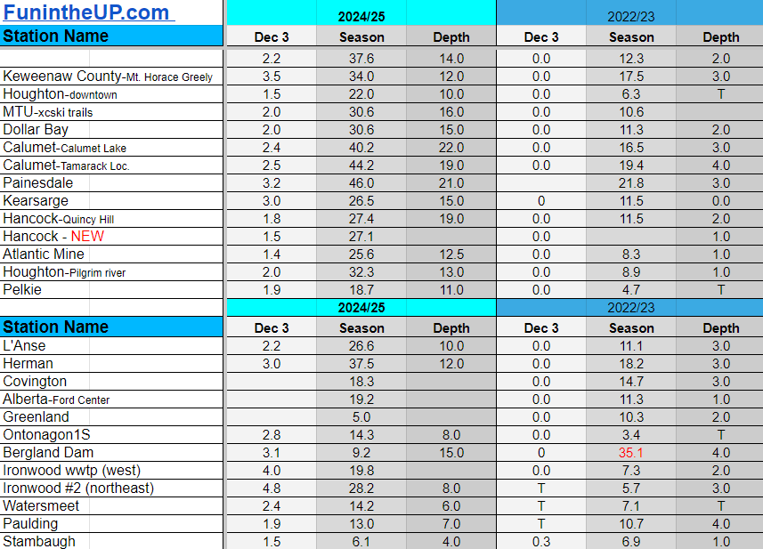
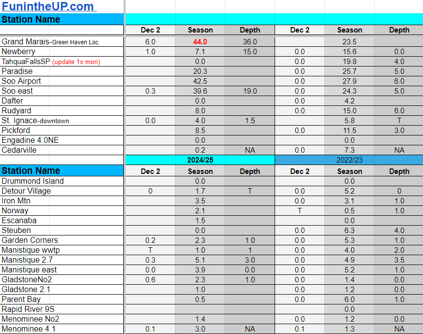
Snowfall on Dec 2, 2024
Snowfall Reports by Yooper Steve
Daily UP Snowfall for 2024/25
Today's Notes:
Below you'll find the snow totals for Dec 2nd.
Be sure to check out the Yooper Steve Amazon Store for my recommended products
Most snowfall Dec 2: Clarksburg with 9 inches
Most snowfall, season to date: Grand Marais with 44 inches
Biggest 24hr total this season: Soo Airport with 15.7 inches (11.30.24)
Do you enjoy FunintheUP videos and seeing the Snowfall Totals all winter? Consider supporting FunintheUP via PayPal - via Venmo
Become a monthly FunintheUP Fan Supporter
Thanks for following the UP Snow Totals page on FunintheUP.com
FunintheUP Youtube channel
TourDaYoop Youtube channel
FunintheUP on TikTok
Yooper Steve on Facebook
Yooper Steve on Instagram
FunintheUP on Instagram
If daily slot is 0" the station hasn't updated or recorded no snowfall.
Sometimes a station won't update that day and does the next day.
Tahquamenon Falls State Park only updates at the end of each month.
Keweenaw county and Houghton County Airport only update during the weekdays.
Sanderson Field Airport (Soo) updates next day.
Dec 2
NOTE: Hover cursor over images to enlarge snowfall totals.
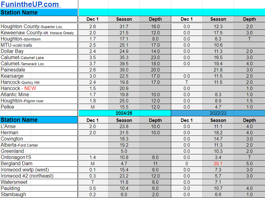
Snowfall on Dec 1st, 2024
Snowfall Reports by Yooper Steve
Daily UP Snowfall for 2024/25
Today's Notes:
Below you'll find the snow totals for Dec 1st.
Be sure to check out the Yooper Steve Amazon Store for my recommended products
Most snowfall Dec 1: Munising with 10.3 inches
Most snowfall, season to date: Soo Airport with 42.5 inches
Biggest 24hr total this season: Soo Airport with 15.7 inches (11.30.24)
Do you enjoy FunintheUP videos and seeing the Snowfall Totals all winter? Consider supporting FunintheUP via PayPal - via Venmo
Become a monthly FunintheUP Fan Supporter
Thanks for following the UP Snow Totals page on FunintheUP.com
FunintheUP Youtube channel
TourDaYoop Youtube channel
FunintheUP on TikTok
Yooper Steve on Facebook
Yooper Steve on Instagram
FunintheUP on Instagram
If daily slot is 0" the station hasn't updated or recorded no snowfall.
Sometimes a station won't update that day and does the next day.
Tahquamenon Falls State Park only updates at the end of each month.
Keweenaw county and Houghton County Airport only update during the weekdays.
Sanderson Field Airport (Soo) updates next day.
Dec 1
NOTE: Hover cursor over images to enlarge snowfall totals.