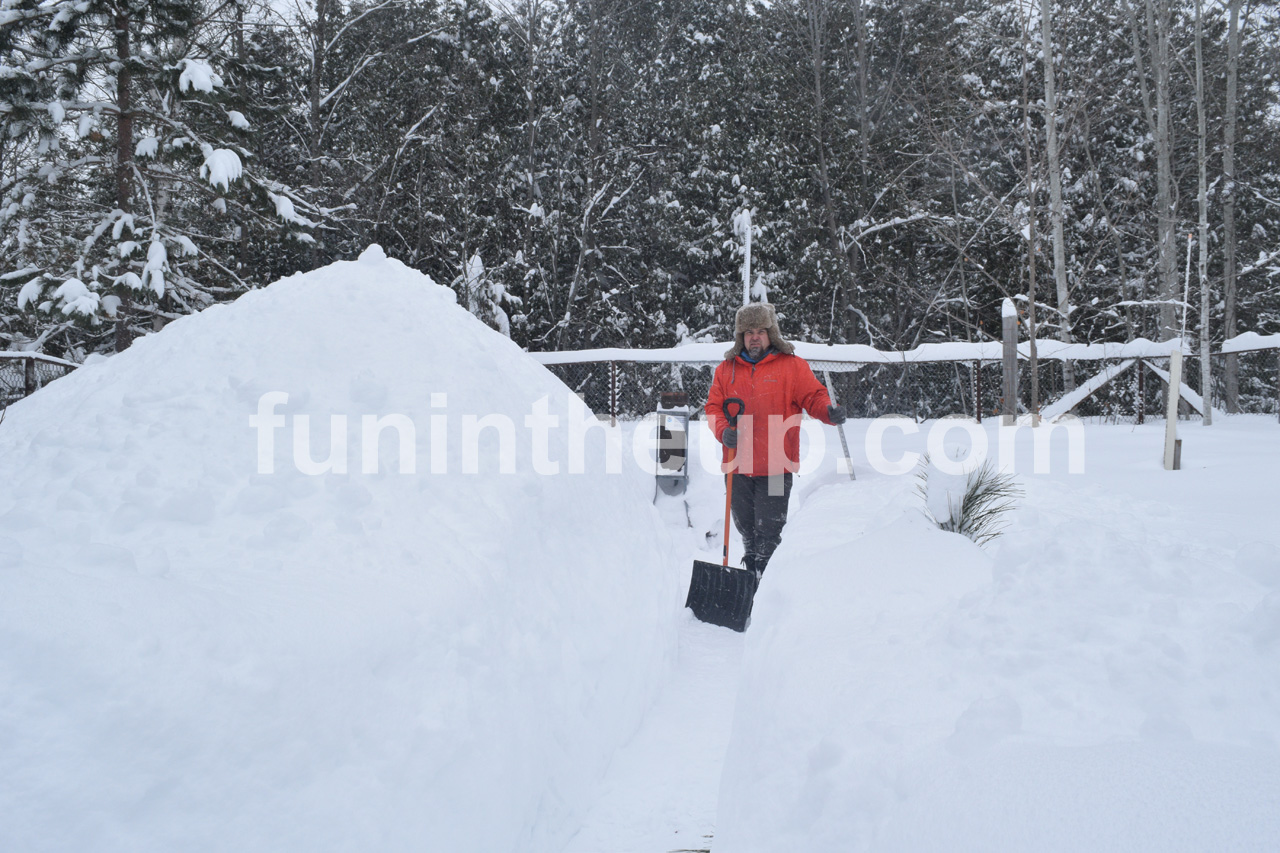
Good day to you friend, winter is here again in the Upper Peninsula, are you ready for another snowy and cold winter? Snowfall is a big part of life in the Upper Peninsula and very memorable, we Yoopers love to talk about how much snow we get each winter. This is the 15th year of snowfall reports on FunintheUP.com, thanks for following the snowfall page!
Thousands of people follow from all 50 states and people from all over the world follow FunintheUP Snowfall Reports all winter. The snowfall totals are used by snowmobilers, news stations, emergency personnel, city officials, road crews, skiers, snowboarders, groomers, ski resorts. The most snow for 2023/24 was at the Calumet Tamarack loation snow station with 173 inches of snow you can view last years snow totals here. Begin looking at the 2024/25 winter season snowfall totals below along with other snowfall data and info.
--Thank you so much for your support for over the years, Yooper Steve.
Whose woods these are I think I know. His house is in the village though. He will not see me stopping here. To watch his woods fill up with snow.
-- Robert Frost (1874-1963)
Previous Years Snowfall Totals
2023/2024 Upper Peninsula Snowfall - 2022/2023 Upper Peninsula Snowfall2021/2022 Upper Peninsula Snowfall - 2019/2020 Upper Peninsula Snowfall - 2018/2019 Upper Peninsula Snowfall
2017/2018 Upper Peninsula Snowfall - 2016/2017 Upper Peninsula Snowfall - 2014/15 Upper Peninsula Snowfall
Top 5 snowfall amounts in the Upper Peninsula.
390.4" - 1978/79 - Keweenaw county (near Delaware)
384.0" - 1996/97 - Herman
367.4" - 1995/96 - Keweenaw county (near Delaware)
362.8" - 2018/19 - Tamarack location (near Calumet)
354.1" - 1978/79 - Houghton county airport
384.0" - 1996/97 - Herman
367.4" - 1995/96 - Keweenaw county (near Delaware)
354.1" - 1978/79 - Houghton county airport
Thank you so much for your support! -- Yooper Steve I'll be doing snow updates all winter on Facebook, Instagram, TikTok, and Youtube so be sure to follow and subscribe on those socials if you aren't already.
Snowfall on Mar 19, 2025
Snowfall Reports by Yooper Steve
Today's Notes:
This post first posted on the Yooper Report - FunintheUP Substack, it is an email newsletter that is sent out to subscribers.
Spring is in the air. Winter is starting to wind down, with days getting warmer and the sunshine starting to shine, and with more daylight to enjoy the best of winter has now passed us by as we move into the green of spring, but not before we see more snow, more on that below.
The snowstorm I thought was going to hit on Monday and Tuesday shifted into Wednesday. All the forecasts had the storm giving western Marquette county and eastern and southern Baraga county the higher snowfall amounts. As the system got closer and the winds grew stronger it shifted more south and further east giving areas from Iron Mountain up to Munising, and over to St. Ignace 4-10 inches of snow. Many of those areas north of M28 had bare ground for a good week already and few small snowbanks left to melt.
It isn’t unusual to see snowflakes this time of the year, into April, and the last snowflakes to fly around Mother’s Day. This year I think will still give us some snow flurries in April and perhaps in May, but overall snow should be very minimal here on out after this next storm coming on Monday.
Tonight as I write this we are seeing snow across the Keweenaw, central UP, and eastern UP, we should wake up with a few inches on the ground. Over the course of late Saturday morning snow flurries should taper off as the next system moving in from the Rockies sets up for Sunday night into Monday which should bring us some larger snow totals in the range of 4-8 inches. There is still a bit of uncertainty to this system it could bring us some freezing rain and a quick switch to snowfall with winds in the south and switching to the north. Most of the UP should see some snow out of this system, back to snow covered lawns and roadways for a few more days.
I’ll have the next update for you late Sunday night, tomorrow I am going winter camping and Sunday on a snowshoe hike and exploring during the day.
Paid subscriptions on Substack allow these snowfall reports and fall color reports to continue each year. Thanks for subscribing to the Yooper Report become a subscriber to get snow totals and snowfall report/forecast emailed to you before they post here on the website.
Check out the FunintheUP Amazon Store - my recommended camping gear, winter clothing, Yooper rock hunting stuff, U.P. books worth reading
Join Yooper Steve on a Guided U.P. Tour to see places you’d never see on your own
UpperPeninsulaTours.com - adventures away from the crowds
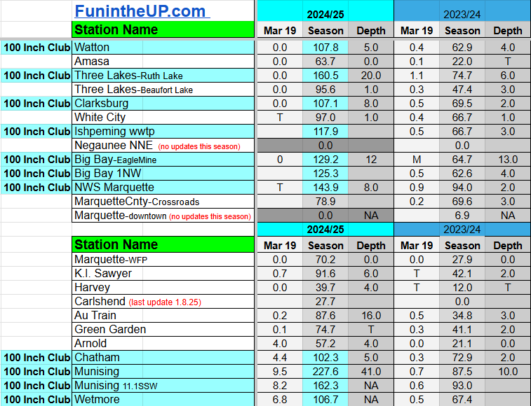
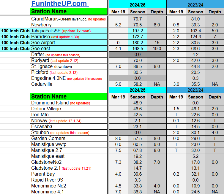
Most snowfall Mar 19: Munising with 9.5 inches
Most snowfall, season to date: Painesdale with 286.9 inches
Biggest 24hr total this season: NWS Marquette with 20.8 inches (3.5.25)
If daily slot is 0" the station hasn't updated or recorded no snowfall.
Sometimes a station won't update that day and does the next day.
Tahquamenon Falls State Park only updates at the end of each month.
Keweenaw county and Houghton County Airport only update during the weekdays.
Sanderson Field Airport (Soo) updates next day.
Mar 19
NOTE: Hover cursor over images to enlarge snowfall totals.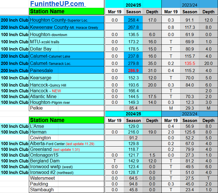

Do you enjoy FunintheUP videos and seeing the Snowfall Totals all winter? Consider supporting FunintheUP via PayPal - via Venmo
Thanks for following the U.P. Snow Totals page on FunintheUP.com
FunintheUP Youtube channel
TourDaYoop Youtube channel
FunintheUP on TikTok
Yooper Steve on Facebook
Yooper Steve on Instagram
FunintheUP on Instagram
Snowfall on Mar 5, 2025
Snowfall Reports by Yooper Steve
Today's Notes:
This post first posted on the Yooper Report - FunintheUP Substack, it is an email newsletter that is sent out to subscribers.
This winter storm added to the totals nicely today with some locations seeing 15-20 inches today from the Keweenaw into western Marquette county. Strong winds continued into the late evening hours Wednesday and by early morning Thursday they had slowed down considerably.
Marquette Coast Guard station recorded wind gusts up to 66mph and wind gusts at Stannard Rock on Lake Superior reached 62mph and winds at Houghton county airport hit 51mph.
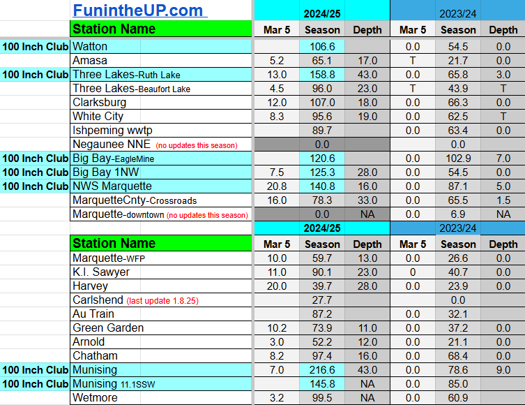
The National Weather Service office in Negaunee township had the highest snow total for the day at 20.8 inches which now is the highest 24hr snow total for this season, which may hold as we get closer to spring.
Painesdale, Calumet/Tamarack loc, and Keweenaw county are pretty close to reaching 300 inches for the year. Painesdale may be the only station to hit 300 inches but Calumet/Tamarack isn’t far behind and Keweenaw county will be really close if it does.
35 locations are now in the 100 Inch Club and 8 stations are in the 200 Inch Club. We should see a handful of more stations to join both before the winter ends.
A couple videos shoveling out this morning at the Calumet/Tamarack weather station. Enjoyed some sunshine today as well.
Forecast ahead
Looking ahead the weather should be pretty mild with a few flurries Friday and Saturday. Sunday it appears the next clipper that is moving into the area may just stay just north over Lake Superior so we should stay snow free until later in the week. Sunday and Monday will be warmer with temperatures getting back into the 40s on both days and we may even see some 50s on Monday. Expect some good snow melt which should make for some nice water holes in parking lots and driveways. The warmup should also bring more potholes so watch out for those as you drive around on the roadways.
Remainder of the week we should see fairly mild temperatures and nothing to significant. Looking forward to the period of March 14th-17th we may see another storm system arriving that could bring us similar snow totals on this last storm system.
Paid subscriptions on Substack allow these snowfall reports and fall color reports to continue each year. Thanks for subscribing to the Yooper Report become a subscriber to get snow totals and snowfall report/forecast emailed to you before they post here on the website.
Check out the FunintheUP Amazon Store - my recommended camping gear, winter clothing, Yooper rock hunting stuff, U.P. books worth reading
Join Yooper Steve on a Guided U.P. Tour to see places you’d never see on your own
UpperPeninsulaTours.com - adventures away from the crowds
Most snowfall Mar 5: NWS Marquette with 20.8 inches
Most snowfall, season to date: Painesdale with 285.8 inches
Biggest 24hr total this season: NWS Marquette with 20.8 inches (3.5.25)
If daily slot is 0" the station hasn't updated or recorded no snowfall.
Sometimes a station won't update that day and does the next day.
Tahquamenon Falls State Park only updates at the end of each month.
Keweenaw county and Houghton County Airport only update during the weekdays.
Sanderson Field Airport (Soo) updates next day.
Mar 5
NOTE: Hover cursor over images to enlarge snowfall totals.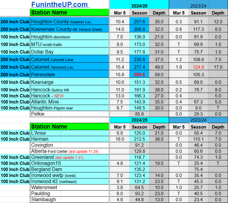
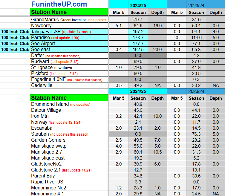

Do you enjoy FunintheUP videos and seeing the Snowfall Totals all winter? Consider supporting FunintheUP via PayPal - via Venmo
Thanks for following the U.P. Snow Totals page on FunintheUP.com
FunintheUP Youtube channel
TourDaYoop Youtube channel
FunintheUP on TikTok
Yooper Steve on Facebook
Yooper Steve on Instagram
FunintheUP on Instagram
Snowfall on Mar 4, 2025
Snowfall Reports by Yooper Steve
Today's Notes:
This post first posted on the Yooper Report - FunintheUP Substack, it is an email newsletter that is sent out to subscribers.
The snowstorm arrived as anticipated and it didn’t disappoint. We didn’t see a lot of snowfall overnight but started seeing the snow pick up when the winds started to shift to the north. The NE wind zones picked up a fair amount of snowfall overnight into early afternoon today, places like the city of Marquette, areas west of Munising, Baraga, Jacobsville, Gay, and Bete Grise, even Copper Harbor. Areas in the far southern UP like Escanaba, Manistique, Engadine, and St. Ignace were seeing mostly rain with a few light flurries later on in the afternoon. I think most locations across the UP should have some snow to measure tomorrow the biggest snow totals should be out of the Michigamme highlands and the Keweenaw.
Wind up to 40mph and blowing snow made for some difficult driving at times but not the worst it wasn’t the worst I’ve driven through this winter. Road crews were out early plowing what snow fell overnight and were continually on the roads today trying to keep up. Intersections in towns and along highways snow built up which proved difficult for some drivers I noticed as I was driving around throughout the day. Lots of drifting across roadways and around buildings and vehicles in parking lots.
Wind gusts:
K.I. Sawyer - 45mph
Houghton county airport - 51mph
Paid subscriptions on Substack allow these snowfall reports and fall color reports to continue each year. Thanks for subscribing to the Yooper Report become a subscriber to get snow totals and snowfall report/forecast emailed to you before they post here on the website.
Check out the FunintheUP Amazon Store - my recommended camping gear, winter clothing, Yooper rock hunting stuff, U.P. books worth reading
Join Yooper Steve on a Guided U.P. Tour to see places you’d never see on your own
UpperPeninsulaTours.com - adventures away from the crowds
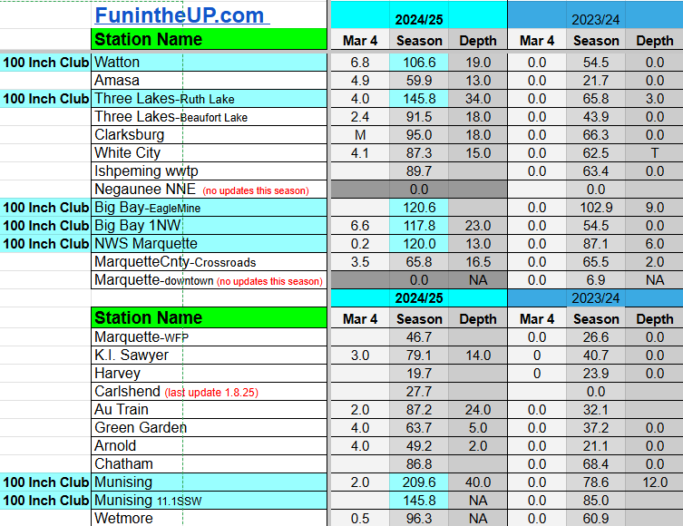
Most snowfall Mar 4: Ironwood #2 with 7.1 inches
Most snowfall, season to date: Painesdale with 270.0 inches
Biggest 24hr total this season: Keweenaw county with 18 inches (2.9.25)
If daily slot is 0" the station hasn't updated or recorded no snowfall.
Sometimes a station won't update that day and does the next day.
Tahquamenon Falls State Park only updates at the end of each month.
Keweenaw county and Houghton County Airport only update during the weekdays.
Sanderson Field Airport (Soo) updates next day.
Mar 4
NOTE: Hover cursor over images to enlarge snowfall totals.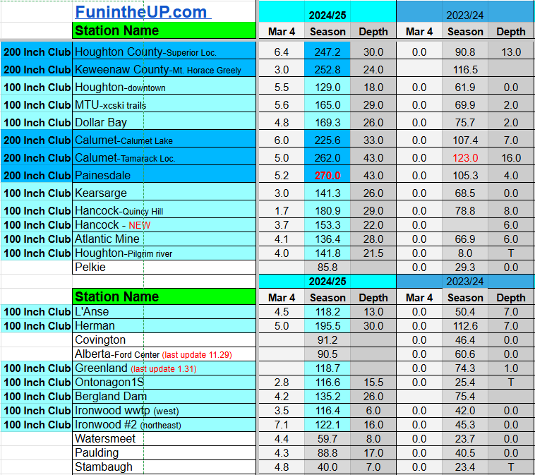


Do you enjoy FunintheUP videos and seeing the Snowfall Totals all winter? Consider supporting FunintheUP via PayPal - via Venmo
Thanks for following the U.P. Snow Totals page on FunintheUP.com
FunintheUP Youtube channel
TourDaYoop Youtube channel
FunintheUP on TikTok
Yooper Steve on Facebook
Yooper Steve on Instagram
FunintheUP on Instagram
Snowfall on Feb 28, 2025
Snowfall Reports by Yooper Steve
Today's Notes:
This post first posted on the Yooper Report - FunintheUP Substack, it is an email newsletter that is sent out to subscribers.
Well the month of February ended with a bang with some more lake effect snow that moved in after cool air moved in behind that little heat wave we saw earlier in the week. We saw 5-11 inches across our NW snowbelts and little to no snowfall in the lower regions of the UP and south eastern UP.
The wind was ripping yesterday with some nice wind gusts all day across the Upper Peninsula, which made for some difficult driving, especially as it got dark.
Those who attended the Copper Dog 150 sled dog race in Calumet had to deal with the winds last night whipping through downtown between the buildings and snow being blown around off the buildings. The cold temperatures and fresh snowfall made for a good race, that warmup we had would have not have been good for the mushers or dogs, they love when it’s cold for racing and also that fresh blanket of snow covered up the hard crusty snow as well. View some pics at the Copper Dog Facebook page.
The days are getting longer and with that warmup earlier in the week it sure felt like spring, but the last couple days it’s back to winter.

Forecast ahead
The next 5-7 days it looks like it will be a bit of a teeter-totter with warmups and cool downs with some snow, rain, and mixed precipitation.
Another storm system looks to be moving in on us starting Tuesday night into Wednesday, could we see another 5-10 inches, very likely, but things are still developing, it’s winter nothing is certain, especially with a mostly ice free Lake Superior in our coldest part of the year. Snowfall will be wet much like the snow we saw Thursday, it was snowman making snow, then Friday it was more fluffy early on then it changed to smaller compact flakes as temperatures dropped into the single digits overnight. But before all this snow arrives we may see some other precipitation in the form of rain which may just stay a bit south and east in the Upper Peninsula on Tuesday, but will have to watch this track as it moves in closer. How fast things transition into snow from rain on Tuesday will depend on how far north the low pressure system moves, if the air mass cools a bit faster than the GFS model shows we could see mostly snowfall by early evening on Tuesday with sunset.
If you will be on the roads late Tuesday night and early Wednesday morning expect some really slick and dangerous conditions on the roadways. Blowing snow shouldn’t be as much of an issue as we saw yesterday and last night with it being really wet snow. North and NW winds will be ripping again, up to 30-40mph gusts in the Western UP along Lake Superior from Ironwood up into the Keweenaw and over into Munising.
Paid subscriptions on Substack allow these snowfall reports and fall color reports to continue each year. Thanks for subscribing to the Yooper Report become a subscriber to get snow totals and snowfall report/forecast emailed to you before they post here on the website.
Check out the FunintheUP Amazon Store - my recommended camping gear, winter clothing, Yooper rock hunting stuff, U.P. books worth reading
Join Yooper Steve on a Guided U.P. Tour to see places you’d never see on your own
UpperPeninsulaTours.com - adventures away from the crowds
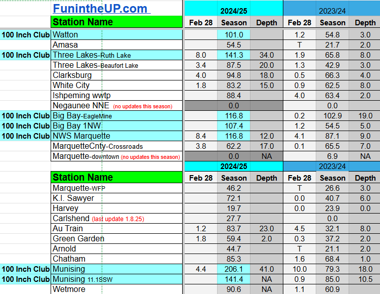
Most snowfall Feb 28: Twin Lakes with 11.0 inches
Most snowfall, season to date: Painesdale with 264.6 inches
Biggest 24hr total this season: Keweenaw county with 18 inches (2.9.25)
If daily slot is 0" the station hasn't updated or recorded no snowfall.
Sometimes a station won't update that day and does the next day.
Tahquamenon Falls State Park only updates at the end of each month.
Keweenaw county and Houghton County Airport only update during the weekdays.
Sanderson Field Airport (Soo) updates next day.
Feb 28
NOTE: Hover cursor over images to enlarge snowfall totals.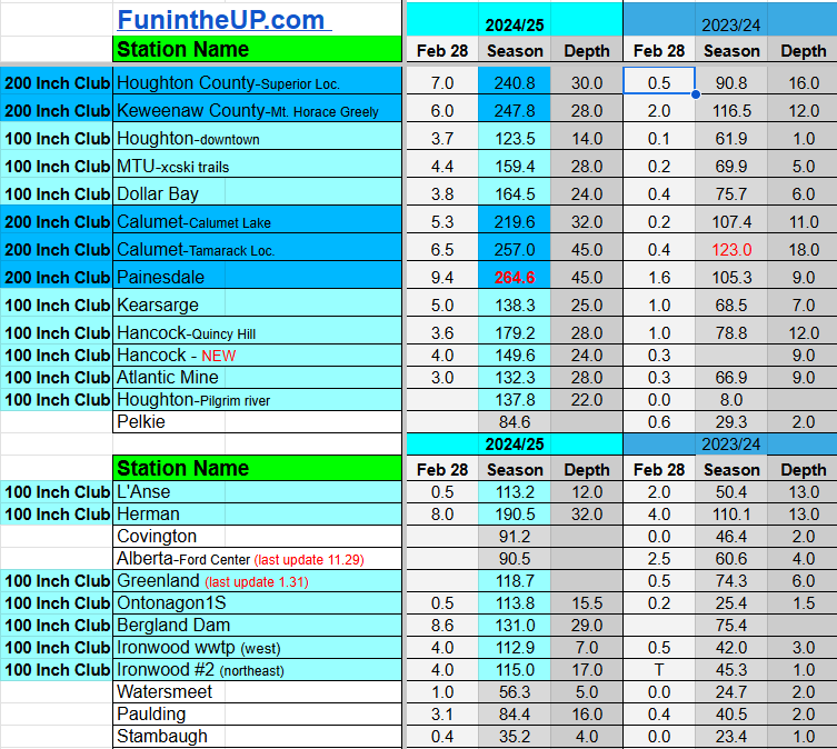


Do you enjoy FunintheUP videos and seeing the Snowfall Totals all winter? Consider supporting FunintheUP via PayPal - via Venmo
Thanks for following the U.P. Snow Totals page on FunintheUP.com
FunintheUP Youtube channel
TourDaYoop Youtube channel
FunintheUP on TikTok
Yooper Steve on Facebook
Yooper Steve on Instagram
FunintheUP on Instagram
Snowfall on Feb 26/27, 2025
Snowfall Reports by Yooper Steve
Today's Notes:
This post first posted on the Yooper Report - FunintheUP Substack, it is an email newsletter that is sent out to subscribers.
Today the post includes a link to the post I wrote up tonight on 3 Keweenaw waterfalls to visit in the winter. Be sure to check it out, it is available as freemium content for all subscribers to the Yooper Report Substack page.
NOTE: On the Yooper Report Substack page I will be starting to make regular posts that will help you with finding things to do, places to stay, history, rock picking, waterfalls, campgrounds, camping, hiking, kayaking, fishing, and more in the Upper Peninsula of Michigan. Some of these posts will be freemium and some will be premium content.
Paid subscriptions on Substack allow these snowfall reports and fall color reports to continue each year. Thanks for subscribing to the Yooper Report become a subscriber to get snow totals and snowfall report/forecast emailed to you before they post here on the website.
Check out the FunintheUP Amazon Store - my recommended camping gear, winter clothing, Yooper rock hunting stuff, U.P. books worth reading
Join Yooper Steve on a Guided U.P. Tour to see places you’d never see on your own - UpperPeninsulaTours.com - adventures away from the crowds
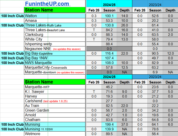
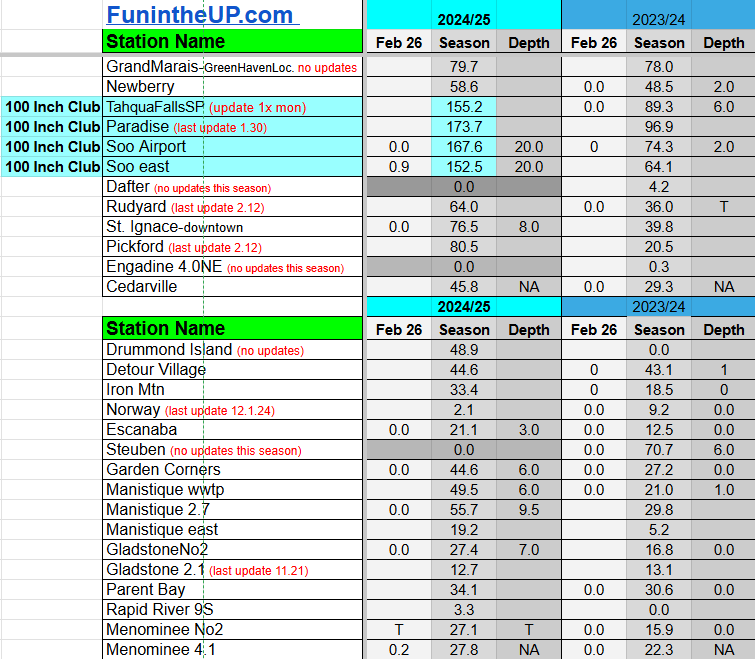
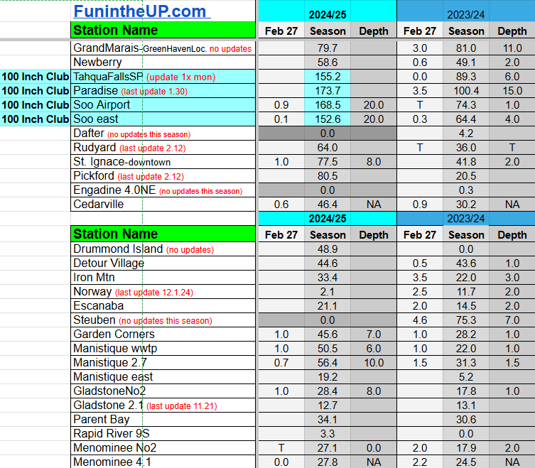
Most snowfall Feb 26: Soo east with 3.0 inches
Most snowfall, season to date: Painesdale with 253.0 inches
Biggest 24hr total this season: Keweenaw county with 18 inches (2.9.25)
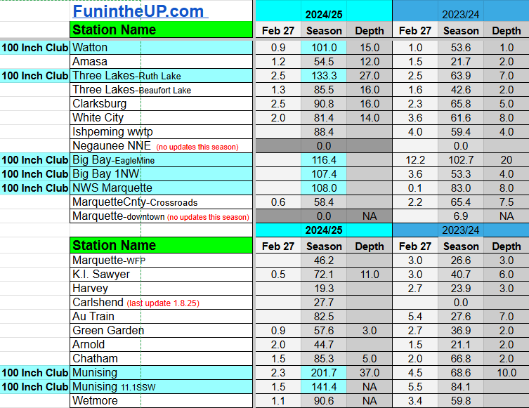
Most snowfall Feb 27: Calumet/Tamarack loc with 3.5 inches
Most snowfall, season to date: Painesdale with 255.2 inches
Biggest 24hr total this season: Keweenaw county with 18 inches (2.9.25)
If daily slot is 0" the station hasn't updated or recorded no snowfall.
Sometimes a station won't update that day and does the next day.
Tahquamenon Falls State Park only updates at the end of each month.
Keweenaw county and Houghton County Airport only update during the weekdays.
Sanderson Field Airport (Soo) updates next day.
Feb 26
NOTE: Hover cursor over images to enlarge snowfall totals.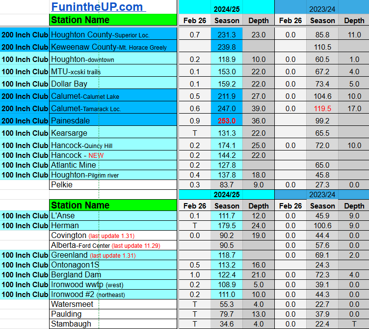

Feb 27
NOTE: Hover cursor over images to enlarge snowfall totals.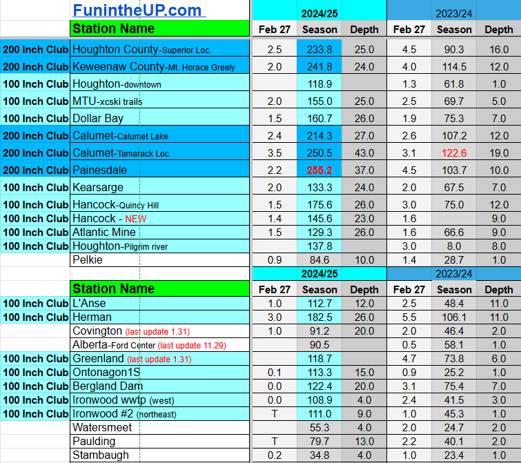

Do you enjoy FunintheUP videos and seeing the Snowfall Totals all winter? Consider supporting FunintheUP via PayPal - via Venmo
Thanks for following the U.P. Snow Totals page on FunintheUP.com
FunintheUP Youtube channel
TourDaYoop Youtube channel
FunintheUP on TikTok
Yooper Steve on Facebook
Yooper Steve on Instagram
FunintheUP on Instagram
Snowfall on Feb 21-24, 2025
Snowfall Reports by Yooper Steve
Today's Notes:
This post first posted on the Yooper Report - FunintheUP Substack, it is an email newsletter that is sent out to subscribers.
After a week with little to no snowfall it is back to winter at least for the next few days. Last week we have saw temperatures reach the mid 40s and even some places saw low 50s. Snowfall on the ground has dropped 10-12 inches at all of my 6 snow stations in the last 5 days. I am fine with a little warmup here and there during the winter and a little sunshine too. When it comes to this time of the year I either want it to just warm up and all the snow to melt or stay cold and snowy through the middle of March.
This year has been more of a normal snowfall year for most locations across the Upper Peninsula as I’ve pointed out in previous posts. Looking at the data from last year at this time to this year you can see some locations are up 140-150 inches from last year, it goes to show you how little snow we had at this time last season.
The middle of February to the middle of March last year we didn’t see much snow but then we saw some of our biggest daily snow totals to close out March. The month of March last year was the second snowiest month last year at most locations across the U.P. which doesn’t happen very often.
Forecast ahead
Well if you were paying attention last week I was writing that we would have a decent snowstorm to closeout this month, and that is the case. So get excited folks if you like winter because this will help with winter recreation activities.Thursday-Saturday we will see some cooler temps back around normal for this time of the year, but that won’t last long as the weekend closes out we will see those temps get back into the low 30s and mid 30s in areas.
Middle of next week we could see another storm system move in bringing a bit of moisture from the south west, bringing some rain and wintery mix. Some cooler Arctic air moving in behind the warm air will bring more lake effect snow. I’ll look at this more closely the next few days and see how thing develop, but I think we are in for a good snowy start to March.
Snow outlook Thursday to Saturday morning
Houghton/Keweenaw - 4 to 12 inches higher elevations in NW snowbeltsIronwood/Bergland - 2-8 inches, areas near Bergland to White Pine may see 4-8”
Ontonagon to Greenland - 2-4”
IronMtn to Escanaba - 2-4”
L’Anse/Baraga - 1-3”
Michigamme to West Ishpeming - 4-6”
Marquette city - 1-3”
Au Train to Munising - 3-5”
Munsing east to Melstrand 4-8”
Newberry/Tahquamenon falls - 3-8”
Soo - 3 to 6”
St Ignace to De Tour Village - 1-2”
Engadine to Manistique - 3-6”
Catch me on the following videos and interviews
𝗧𝗵𝗲 𝗖𝗿𝗼𝘀𝘀𝗶𝗻𝗴 𝗣𝗹𝗮𝗰𝗲 | Winter is More Fun in the U.P. "Yooper" Steve Jurmu
Catch me on The Lakescape Photography Podcast
Paid subscriptions on Substack allow these snowfall reports and fall color reports to continue each year. Thanks for subscribing to the Yooper Report become a subscriber to get snow totals and snowfall report/forecast emailed to you before they post here on the website.
Check out the FunintheUP Amazon Store - my recommended camping gear, winter clothing, Yooper rock hunting stuff, U.P. books worth reading
Join Yooper Steve on a Guided U.P. Tour to see places you’d never see on your own - UpperPeninsulaTours.com - adventures away from the crowds
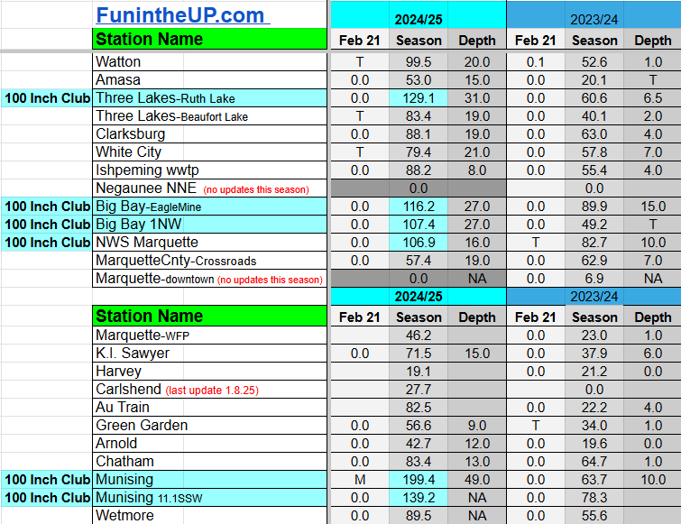
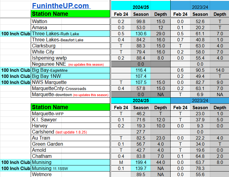
Most snowfall Feb 21: Ironwood 1 and Ironwood 2 both with 0.5 inches
Most snowfall, season to date: Painesdale with 251.0 inches
Biggest 24hr total this season: Keweenaw county with 18 inches (2.9.25)
Most snowfall Feb 22: with inches
Most snowfall, season to date: Painesdale with 251.0 inches
Biggest 24hr total this season: Keweenaw county with 18 inches (2.9.25)
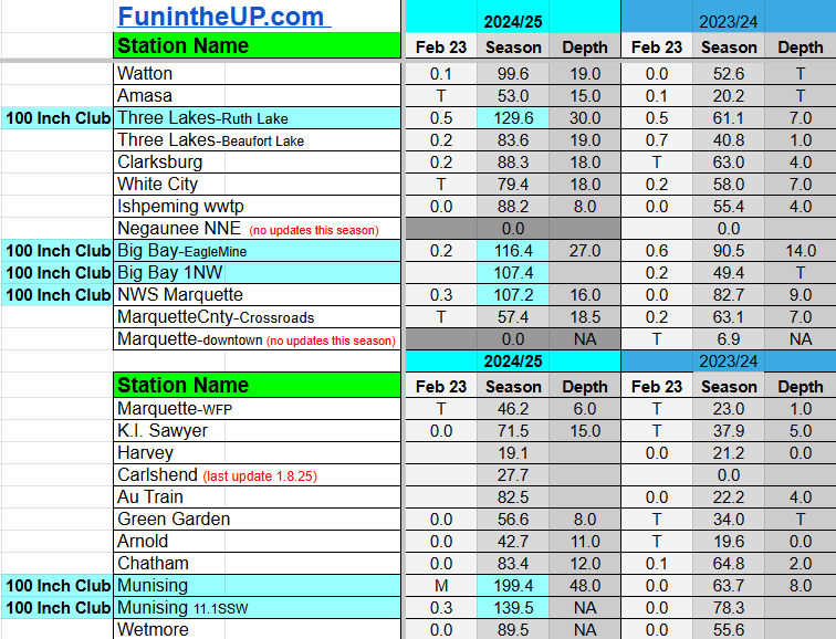
Most snowfall Feb 23: Covington with 1.0 inches
Most snowfall, season to date: Painesdale with 251.9 inches
Biggest 24hr total this season: Keweenaw county with 18 inches (2.9.25)
Most snowfall Feb 24: Herman 2.0 inches
Most snowfall, season to date: Painesdale with 252.1 inches
Biggest 24hr total this season: Keweenaw county with 18 inches (2.9.25)
If daily slot is 0" the station hasn't updated or recorded no snowfall.
Sometimes a station won't update that day and does the next day.
Tahquamenon Falls State Park only updates at the end of each month.
Keweenaw county and Houghton County Airport only update during the weekdays.
Sanderson Field Airport (Soo) updates next day.
Feb 21
NOTE: Hover cursor over images to enlarge snowfall totals.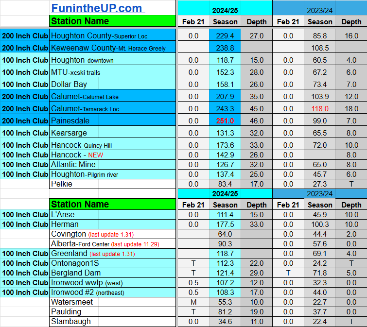
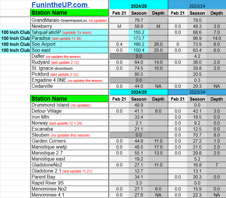

Feb 22
NOTE: Hover cursor over images to enlarge snowfall totals.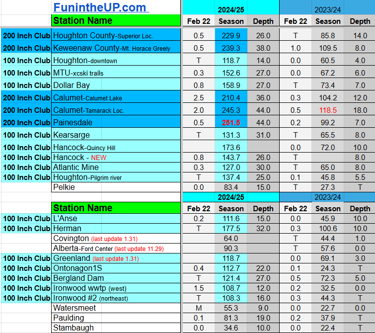
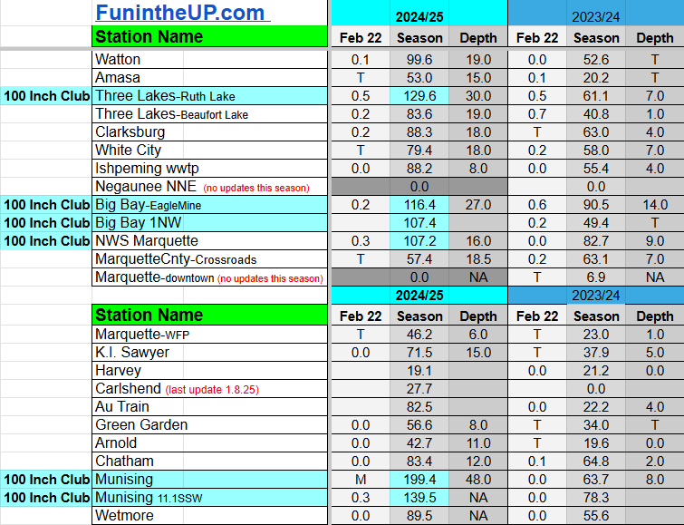


Feb 23
NOTE: Hover cursor over images to enlarge snowfall totals.


Feb 24
NOTE: Hover cursor over images to enlarge snowfall totals.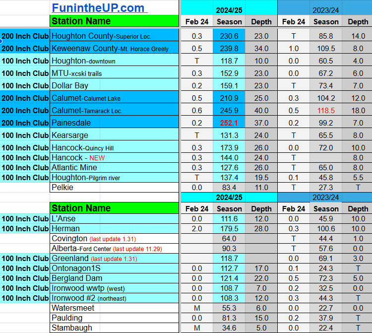


Do you enjoy FunintheUP videos and seeing the Snowfall Totals all winter? Consider supporting FunintheUP via PayPal - via Venmo
Thanks for following the U.P. Snow Totals page on FunintheUP.com
FunintheUP Youtube channel TourDaYoop Youtube channel FunintheUP on TikTok Yooper Steve on Facebook
Yooper Steve on Instagram
FunintheUP on Instagram
Snowfall on Feb 20, 2025
Snowfall Reports by Yooper Steve
Today's Notes:
This post first posted on the Yooper Report - FunintheUP Substack, it is an email newsletter that is sent out to subscribers.
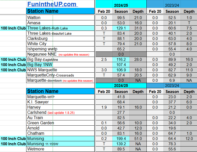
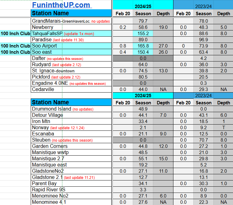
Just a few places in Marquette county and the eastern UP with snowfall and a trace of snowfall in some other places in the UP. Over the course of the next 5 days weather should be pretty mild and then cooling back down to below average for the closeout of February.
With the cold that we have had the last week we have seen ice coverage on the Great Lakes increase almost double from where it was last week. I haven’t looked at the ice coverage for a few days and I was surprised to see it sitting at 45% today on Lake Superior. This may be the highest percentage of ice we may see this winter, but then again this warmup should only last about 5 days before it cools back down again allowing that ice to grow.


Above: Kahtoola Microspikes (link to buy) I use when exploring slippery areas
I’ve had my Microspikes for 10 years
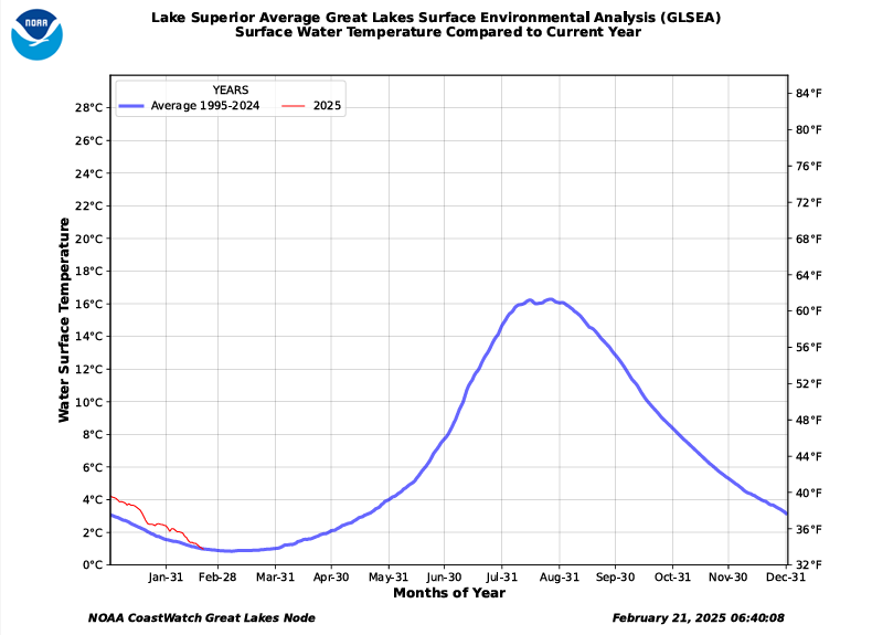
The average surface water temperature for Lake Superior today is 33.7°. Take a look at the chart below and see how warm Lake Superior is compared to the daily average from 1995-2024. The last few years we have seen some warm summers and little rain which has allowed the lake to stay a bit warmer along with the lack of snowfall over the last couple years contributing to lower lake levels. Look for lake levels and water temperatures to move closer to average over the course of the next few years.
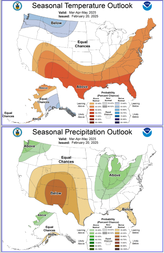
Looking over the 3 month precipitation and temperature outlook issued by NOAA yesterday we can see that temperatures should remain about normal for our region, while precipitation is leaning slightly above normal.
Moving ahead into the month of March I think we will have a few good snowstorms which may bring a few locations to 300 inches of snow before the end of the month. I wouldn’t be surprised as well if we see 15-30 inches in April in the NW snowbelts and in some areas of the central UP, like in western Marquette county areas.
I am looking forward to a little more sunshine and not having to shovel my 6 snowfall stations for the next 5-7 days and just measure the snow if it should happen.
Catch me on the following videos and interviews
𝗧𝗵𝗲 𝗖𝗿𝗼𝘀𝘀𝗶𝗻𝗴 𝗣𝗹𝗮𝗰𝗲 | Winter is More Fun in the U.P. "Yooper" Steve Jurmu
Catch me on The Lakescape Photography Podcast
Paid subscriptions on Substack allow these snowfall reports and fall color reports to continue each year. Thanks for subscribing to the Yooper Report become a subscriber to get snow totals and snowfall report/forecast emailed to you before they post here on the website.
Check out the FunintheUP Amazon Store - my recommended camping gear, winter clothing, Yooper rock hunting stuff, U.P. books worth reading
Join Yooper Steve on a Guided U.P. Tour to see places you’d never see on your own - UpperPeninsulaTours.com - adventures away from the crowds
Most snowfall Feb 20: NWS Marquette office with 3.0 inches
Most snowfall, season to date: Painesdale with 251.0 inches
Biggest 24hr total this season: Keweenaw county with 18 inches (2.9.25)
If daily slot is 0" the station hasn't updated or recorded no snowfall.
Sometimes a station won't update that day and does the next day.
Tahquamenon Falls State Park only updates at the end of each month.
Keweenaw county and Houghton County Airport only update during the weekdays.
Sanderson Field Airport (Soo) updates next day.
Feb 20
NOTE: Hover cursor over images to enlarge snowfall totals.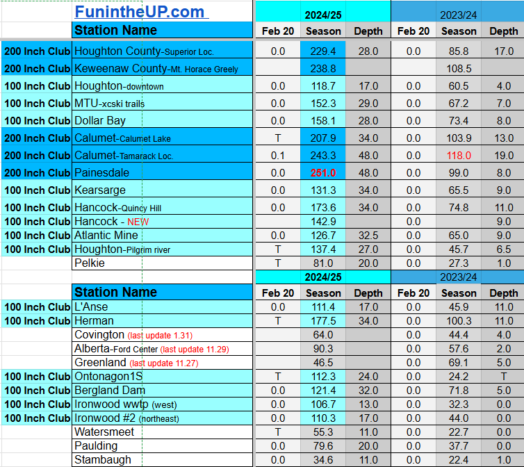

Do you enjoy FunintheUP videos and seeing the Snowfall Totals all winter? Consider supporting FunintheUP via PayPal - via Venmo
Thanks for following the U.P. Snow Totals page on FunintheUP.com
FunintheUP Youtube channel TourDaYoop Youtube channel FunintheUP on TikTok Yooper Steve on Facebook
Yooper Steve on Instagram
FunintheUP on Instagram
Snowfall on Feb 19, 2025
Snowfall Reports by Yooper Steve
Today's Notes:
This post first posted on the Yooper Report - FunintheUP Substack, it is an email newsletter that is sent out to subscribers.
The last 10 days have been snowy especially in the Keweenaw, Painesdale, Calumet, and Central/Delaware where 46 to 64 inches of snow has fallen.
We now have 6 stations in the 200 Inch Club. Twin Lakes just joined today, joining, Calumet Lake, Calumet/Tamarack, Keweenaw county, Painesdale, and Houghton county weather stations. There are two other stations in the eastern U.P. with less than 2 inches to go before they reach it, and with a dry spell coming they might have to wait until next week or longer to join the club. Next two stations are more than 25 inches away so it will be a little bit before they reach it.
Here are some fun stats for a few weather stations for this winter up to today’s snowfall measurement the 19th.
Calumet/Tamarack weather station
I have only had 14 of 89 days with no measurable snowfall since Nov 23rd when the snow finally stuck on the ground on the ground for good. There was 4.3 inches of snow that fell before that but it all melted.
There were 11 days in December with no snowfall. The bulk of the time period with no snow was Dec 21st to Dec 29th where we saw temps as high as 42 degrees on Dec 28th. There has only been 3 days since Jan 1st with no measurable snowfall up to Feb 19th snowfall measurement. Tomorrow morning might break the streak of 20 days in a row with measurable snowfall.
National Weather Service Marquette
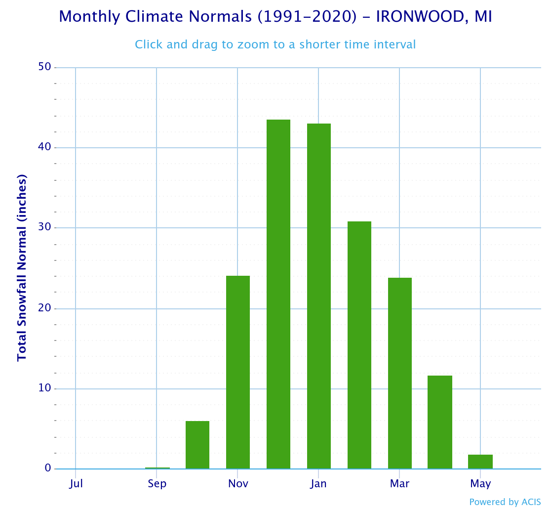
There has been 103.8 inches of snow that has fallen for the season so far. The average snow total for the season is 188 inches with data going back to 61/62. Average snowfall from first snowfall through the month of February is 136.1 inches. There is still another 8 days to get to that average, but 32 inches will be hard to make up. Just to hit the season average the NWS Mqt office needs another 51.9 inches of snow, yes that is possible but without another couple snowstorms before the end of the month, it is unlikely 188 inches of snow will be reached at the NWS office in Negaunee township.
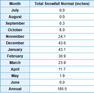
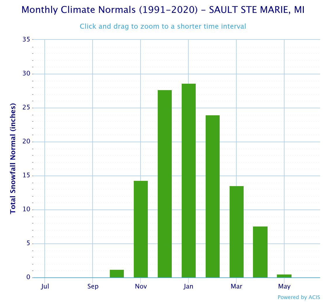
Below I have included some charts for some weather stations in the Upper Peninsula. The monthly and yearly data in the graph only shows the averages from 1991 to 2020, but it gives you an idea of snowfall comparisons to this year so far.
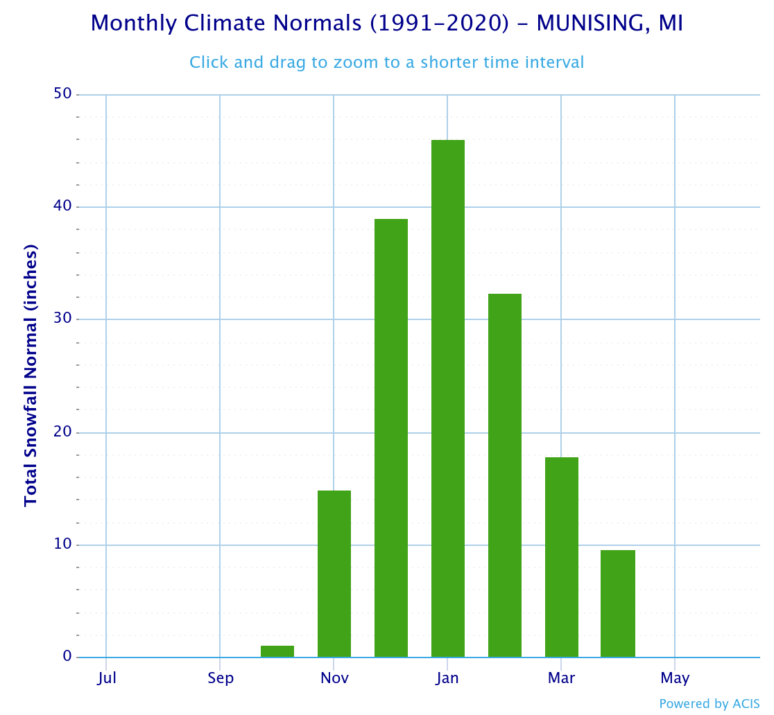
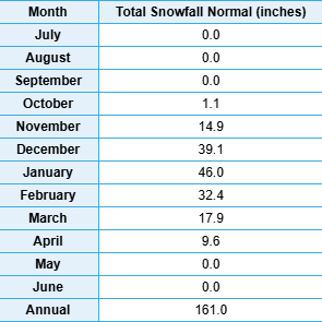
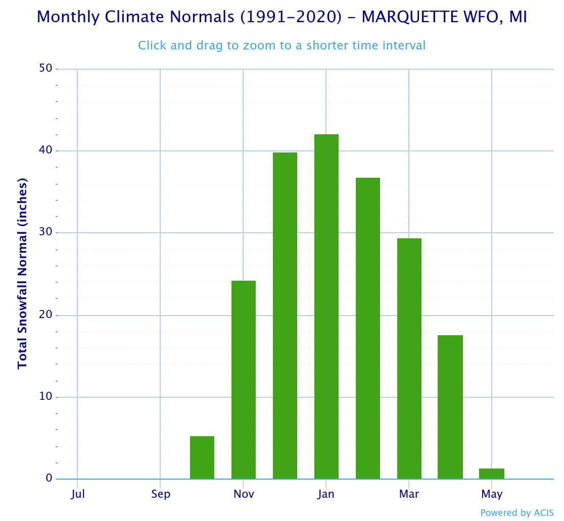
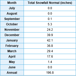

Looking ahead at snow and temperatures Forecast ahead is a mild one, little snow besides a few flurries in the Keweenaw most likely Sunday into Monday morning. Elsewhere flurries are possible but a low probability at this time.
Temperatures should get above freezing across most of the Upper Peninsula on Sunday, Monday, and Tuesday with a few places possibly seeing it break 40 degrees. Heading into next weekend things should start cooling back down a little closer to normal temps with another possible snowstorm the last few days of the month into the first couple days of March.
Catch me on the following videos and interviews
𝗧𝗵𝗲 𝗖𝗿𝗼𝘀𝘀𝗶𝗻𝗴 𝗣𝗹𝗮𝗰𝗲 | Winter is More Fun in the U.P. "Yooper" Steve Jurmu
Catch me on The Lakescape Photography Podcast
Paid subscriptions on Substack allow these snowfall reports and fall color reports to continue each year. Thanks for subscribing to the Yooper Report become a subscriber to get snow totals and snowfall report/forecast emailed to you before they post here on the website.
Check out the FunintheUP Amazon Store - my recommended camping gear, winter clothing, Yooper rock hunting stuff, U.P. books worth reading
Join Yooper Steve on a Guided U.P. Tour to see places you’d never see on your own - UpperPeninsulaTours.com - adventures away from the crowds
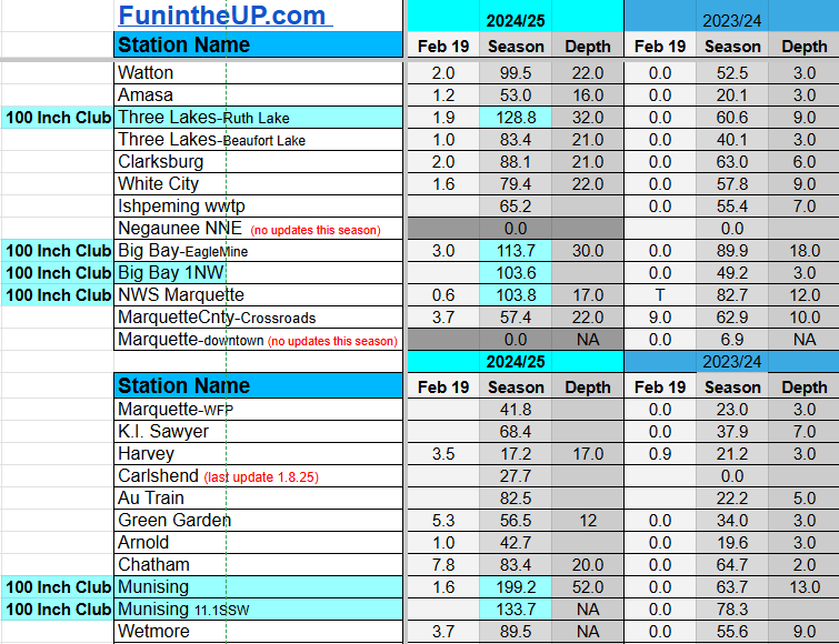
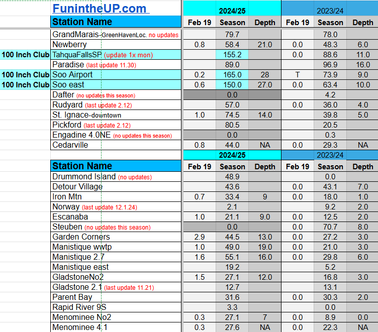
Most snowfall Feb 19: Calumet/Tamarack loc with 7.8 inches
Most snowfall, season to date: Painesdale with 251.0 inches
Biggest 24hr total this season: Keweenaw county with 18 inches (2.9.25)
If daily slot is 0" the station hasn't updated or recorded no snowfall.
Sometimes a station won't update that day and does the next day.
Tahquamenon Falls State Park only updates at the end of each month.
Keweenaw county and Houghton County Airport only update during the weekdays.
Sanderson Field Airport (Soo) updates next day.
Feb 19
NOTE: Hover cursor over images to enlarge snowfall totals.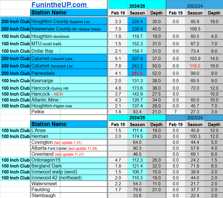

Do you enjoy FunintheUP videos and seeing the Snowfall Totals all winter? Consider supporting FunintheUP via PayPal - via Venmo
Thanks for following the U.P. Snow Totals page on FunintheUP.com
FunintheUP Youtube channel TourDaYoop Youtube channel FunintheUP on TikTok Yooper Steve on Facebook
Yooper Steve on Instagram
FunintheUP on Instagram
Snowfall on Feb 17/18, 2025
Snowfall Reports by Yooper Steve
Today's Notes:
This post first posted on the Yooper Report - FunintheUP Substack, it is an email newsletter that is sent out to subscribers.
The first half of February we have seen a decent amount of snow. Snow totals for the month are about equal to all the snow in the month of January for most stations with some a few inches below while others are almost half of last months total as of today.
The Keweenaw has been seeing the most snowfall for the month of February especially from Calumet to Central and Delaware areas.
Below are the 3 locations with the most snow in the month of February (Feb1-Feb18), they just so happen to be the 3 snowiest locations in the Upper Peninsula as well.
Painesdale - 58”
Keweenaw county - 75”
Tamarack loc - 77.3”
Thursday there will be a few lingering snow flurries through the day in the your NW snowbelts bringing 1-2 inches through the day. Sunday we may see a little moisture being pulled into the region as a low progresses from the SE giving us the possibility of widespread snow flurries across the Upper Peninsula, Sunday afternoon into Monday morning.
We are looking at temperatures increasing into the weekend starting Friday during the day, temps should reach the low to mid 20s across the Upper Peninsula. By Sunday and Monday we will see low to mid 30s with some possible low 40s in some places.
Ultimately there really isn’t anything to significant on the horizon for snowfall for the next 7 days at least, only some light flurries right now. It won’t be until the last few days of February when we should see some more cold air moving into the Great Lakes region bringing the possibility of more heavy lake effect snow with it.
Catch me on the following videos and interviews
𝗧𝗵𝗲 𝗖𝗿𝗼𝘀𝘀𝗶𝗻𝗴 𝗣𝗹𝗮𝗰𝗲 | Winter is More Fun in the U.P. "Yooper" Steve Jurmu
Catch me on The Lakescape Photography Podcast
Paid subscriptions on Substack allow these snowfall reports and fall color reports to continue each year. Thanks for subscribing to the Yooper Report become a subscriber to get snow totals and snowfall report/forecast emailed to you before they post here on the website.
Check out the FunintheUP Amazon Store - my recommended camping gear, winter clothing, Yooper rock hunting stuff, U.P. books worth reading
Join Yooper Steve on a Guided U.P. Tour to see places you’d never see on your own - UpperPeninsulaTours.com - adventures away from the crowds
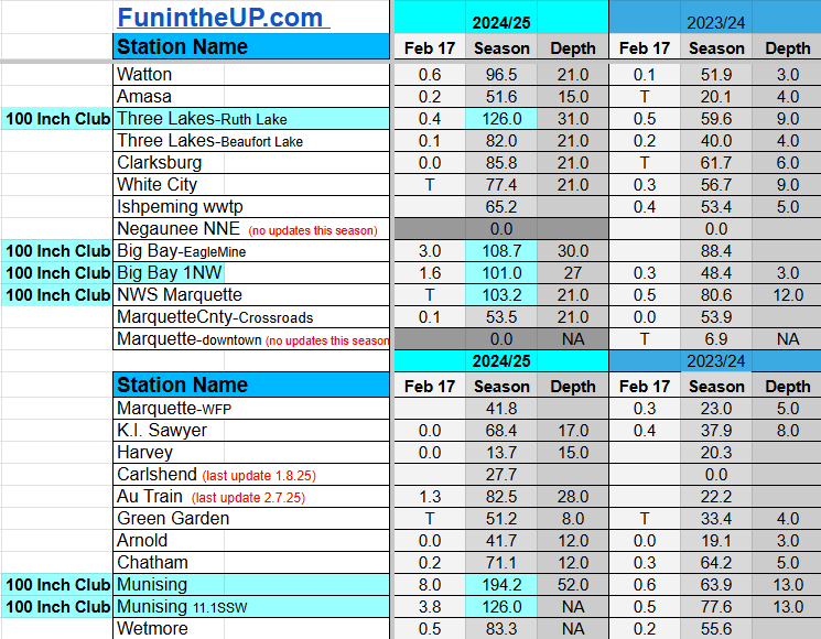
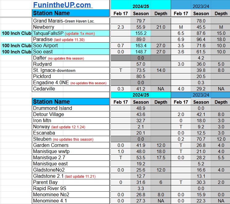
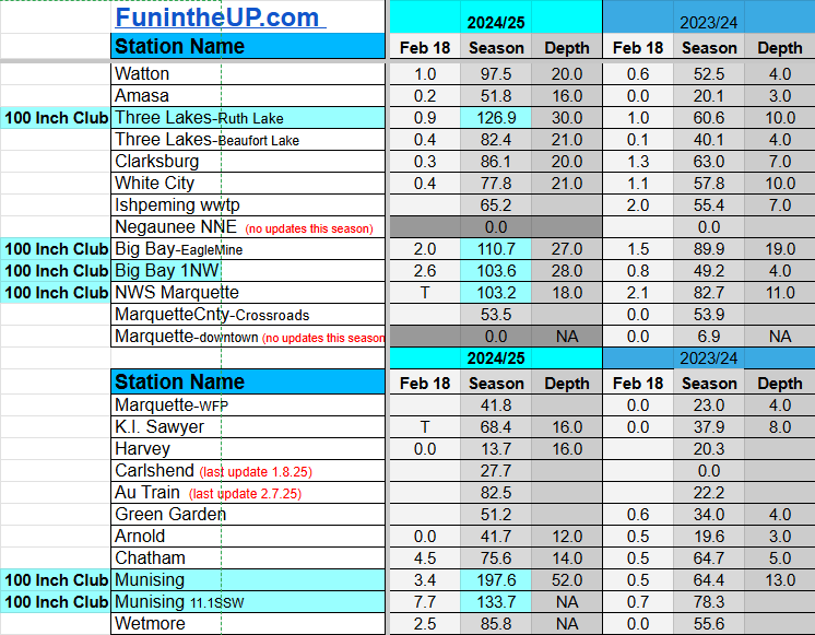
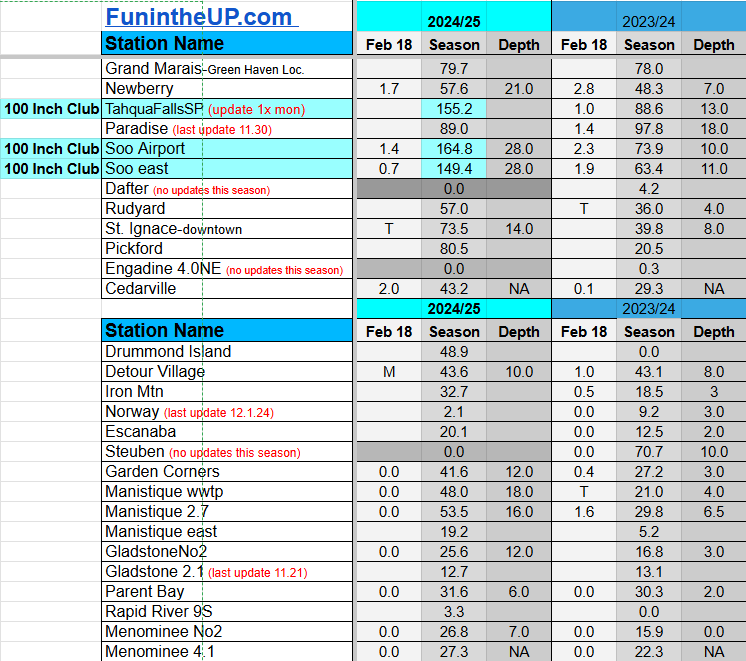
Most snowfall Feb 17: Munising with 8.0 inches
Most snowfall, season to date: Painesdale with 243.6 inches
Biggest 24hr total this season: Keweenaw county with 18 inches (2.9.25)
Most snowfall Feb 18: Munising 11.1SSW with 7.7 inches
Most snowfall, season to date: Painesdale with 246.9 inches
Biggest 24hr total this season: Keweenaw county with 18 inches (2.9.25)
If daily slot is 0" the station hasn't updated or recorded no snowfall.
Sometimes a station won't update that day and does the next day.
Tahquamenon Falls State Park only updates at the end of each month.
Keweenaw county and Houghton County Airport only update during the weekdays.
Sanderson Field Airport (Soo) updates next day.
Feb 17
NOTE: Hover cursor over images to enlarge snowfall totals.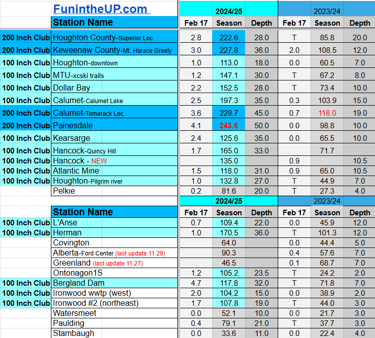

Feb 18
NOTE: Hover cursor over images to enlarge snowfall totals.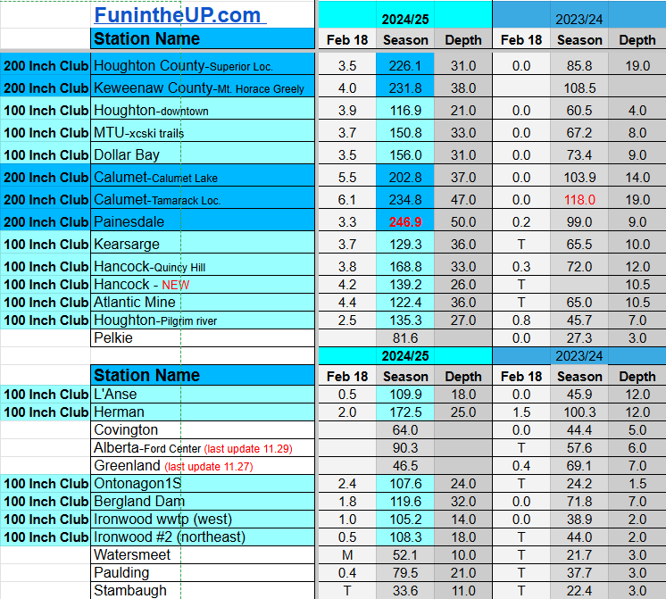

Do you enjoy FunintheUP videos and seeing the Snowfall Totals all winter? Consider supporting FunintheUP via PayPal - via Venmo
Thanks for following the U.P. Snow Totals page on FunintheUP.com
FunintheUP Youtube channel TourDaYoop Youtube channel FunintheUP on TikTok Yooper Steve on Facebook
Yooper Steve on Instagram
FunintheUP on Instagram
Snowfall on Feb 15/16, 2025
Snowfall Reports by Yooper Steve
Today's Notes:
This post first posted on the Yooper Report - FunintheUP Substack, it is an email newsletter that is sent out to subscribers.
Snow has been consistently falling across the Keweenaw at a good clip this last week and a half bringing. Stations listed below had 40+ inches since Feb 9th.
Calumet (Calumet lake) - 42.4”
Calumet/Tamarack loc - 45.7”
Keweenaw county - 48.0”
We now have 30 snow stations at 100+ inches of snowfall for the season, that is a stark comparison to last year at this time when there were only 4 stations that reached 100+ inches. It hasn’t been extremely snowy only in a few spots like Munising to the Soo. Places around the Keweenaw have been about average or below average for the most part. Then we look at areas in the western U.P. like Ironwood and Bergland and they are slightly below average. Areas from Iron Mountain, to Escanaba, Manistique, Engadine, St. Ignace etc along the southern parts of the Upper Peninsula I think are a mixed bag below average, average, and above average.
One thing is for certain and that is the Upper Peninsula does have snowfall, some might say it’s the most they’ve seen, others might say I’ve seen a lot more, while others might be telling themselves they should move back south where it’s warmer and it doesn’t snow but a few inches once every 10 years. No matter how you look at it there will always be another winter you can compare to this one, how you perceive it is up to you and what winters you have experienced in the Upper Peninsula.
Cool Arctic air mass will remain around for a few more days until Wednesday night when winds shift to the south bringing with it mid teens Thursday and mid 20s by Friday afternoon. For those who want warmer temperatures wait until Sunday when we could see the mid 30s across the Upper Peninsula.
Snowfall will mainly be over the next few days into Thursday night. The NW snowbelts could see 4-6 inches over the next couple days. Wednesday we could see some convergent winds with north winds across Alger county which could bring some whiteout conditions throughout the day which could cause M28 to be shut down and around 4-6” of snow to fall around Munising, Wetmore, and north of Shingleton.
Paid subscriptions on Substack allow these snowfall reports and fall color reports to continue each year. Thanks for subscribing to the Yooper Report become a subscriber to get snow totals and snowfall report/forecast emailed to you before they post here on the website.
Check out the FunintheUP Amazon Store - my recommended camping gear, winter clothing, Yooper rock hunting stuff, U.P. books worth reading
Join Yooper Steve on a Guided U.P. Tour to see places you’d never see on your own - UpperPeninsulaTours.com - adventures away from the crowds
Most snowfall Feb 15: K.I. Sawyer with 11.8 inches
Most snowfall, season to date: Painesdale with 236.5 inches
Biggest 24hr total this season: Keweenaw county with 18 inches (2.9.25)
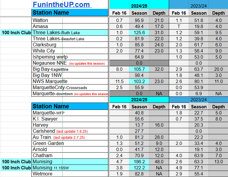
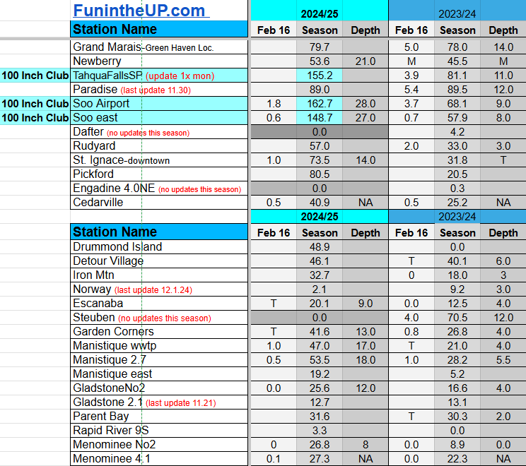
Most snowfall Feb 16: NWS Marquette with 11.5 inches
Most snowfall, season to date: Painesdale with 239.5 inches
Biggest 24hr total this season: Keweenaw county with 18 inches (2.9.25)
If daily slot is 0" the station hasn't updated or recorded no snowfall.
Sometimes a station won't update that day and does the next day.
Tahquamenon Falls State Park only updates at the end of each month.
Keweenaw county and Houghton County Airport only update during the weekdays.
Sanderson Field Airport (Soo) updates next day.
Feb 15
NOTE: Hover cursor over images to enlarge snowfall totals.
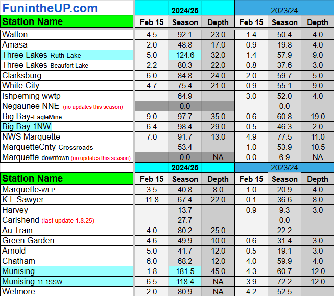


Feb 16
NOTE: Hover cursor over images to enlarge snowfall totals.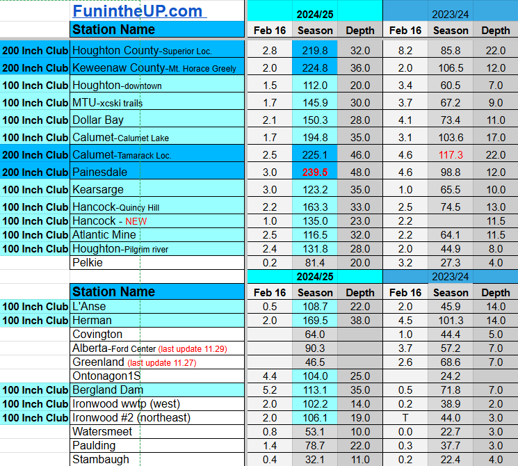

Do you enjoy FunintheUP videos and seeing the Snowfall Totals all winter? Consider supporting FunintheUP via PayPal - via Venmo
Thanks for following the U.P. Snow Totals page on FunintheUP.com
FunintheUP Youtube channel TourDaYoop Youtube channel FunintheUP on TikTok Yooper Steve on Facebook
Yooper Steve on Instagram
FunintheUP on Instagram
Snowfall on Feb 13/14, 2025
Snowfall Reports by Yooper Steve
Today's Notes:
This post first posted on the Yooper Report - FunintheUP Substack, it is an email newsletter that is sent out to subscribers.
Paid subscriptions on Substack allow these snowfall reports and fall color reports to continue each year. Thanks for subscribing to the Yooper Report become a subscriber to get snow totals and snowfall report/forecast emailed to you before they post here on the website.
Check out the FunintheUP Amazon Store - my recommended camping gear, winter clothing, Yooper rock hunting stuff, U.P. books worth reading
Join Yooper Steve on a Guided U.P. Tour to see places you’d never see on your own - UpperPeninsulaTours.com - adventures away from the crowds
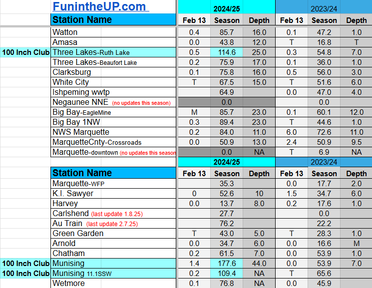
Most snowfall Feb 13: McMillan with 4.5 inches
Most snowfall, season to date: Painesdale with 221.7 inches
Biggest 24hr total this season: Keweenaw county with 18 inches (2.9.25)
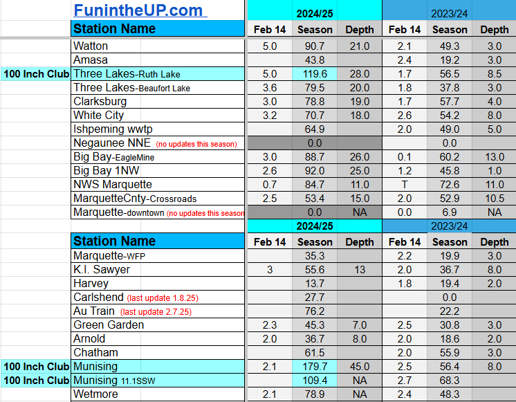
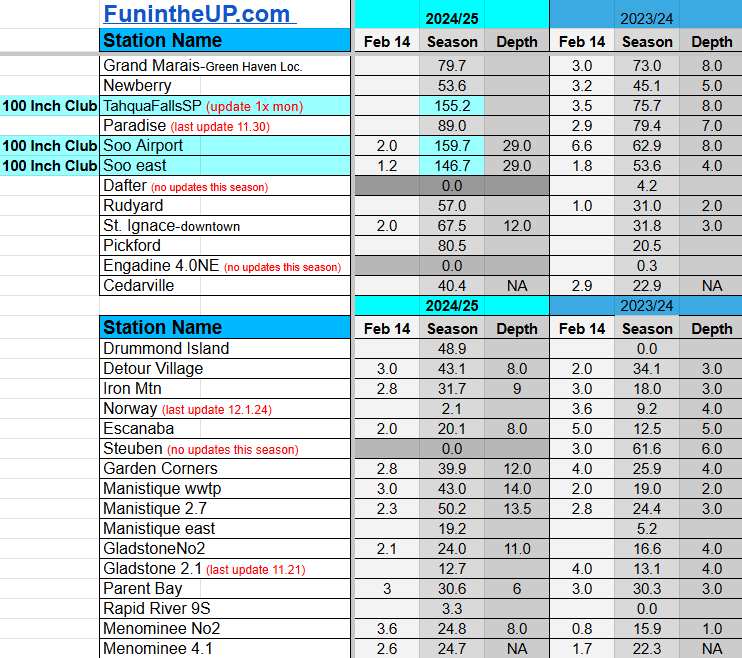
Most snowfall Feb 14: Houghton county with 7.5 inches
Most snowfall, season to date: Painesdale with 228.3 inches
Biggest 24hr total this season: Keweenaw county with 18 inches (2.9.25)
If daily slot is 0" the station hasn't updated or recorded no snowfall.
Sometimes a station won't update that day and does the next day.
Tahquamenon Falls State Park only updates at the end of each month.
Keweenaw county and Houghton County Airport only update during the weekdays.
Sanderson Field Airport (Soo) updates next day.
Feb 13
NOTE: Hover cursor over images to enlarge snowfall totals.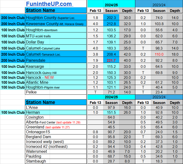
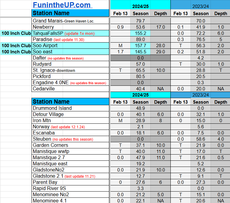

Feb 14
NOTE: Hover cursor over images to enlarge snowfall totals.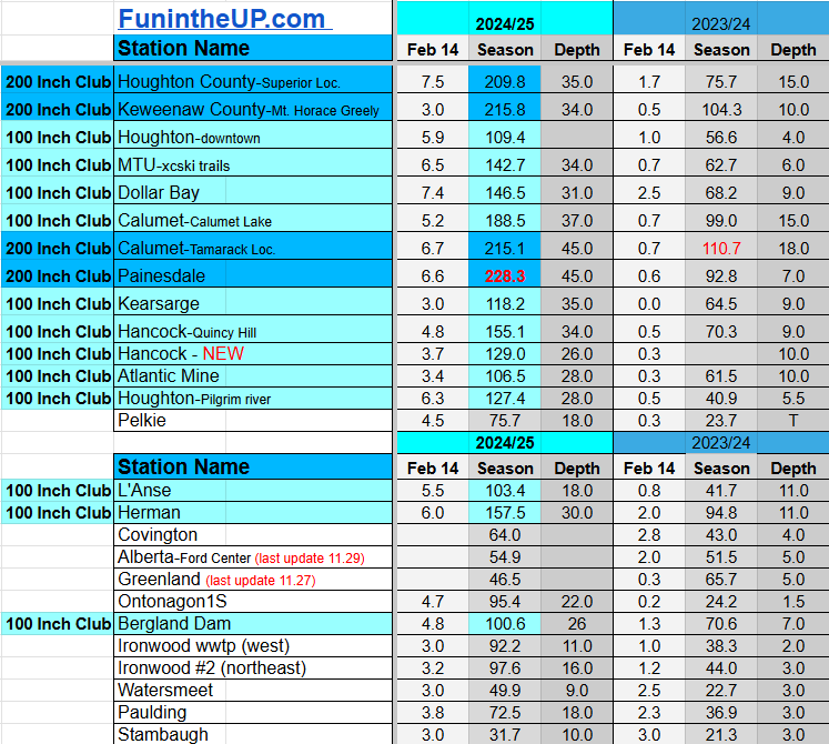

Do you enjoy FunintheUP videos and seeing the Snowfall Totals all winter? Consider supporting FunintheUP via PayPal - via Venmo
Thanks for following the U.P. Snow Totals page on FunintheUP.com
FunintheUP Youtube channel TourDaYoop Youtube channel FunintheUP on TikTok Yooper Steve on Facebook
Yooper Steve on Instagram
FunintheUP on Instagram
Snowfall on Feb 12, 2025
Snowfall Reports by Yooper Steve
Today's Notes:
This post first posted on the Yooper Report - FunintheUP Substack, it is an email newsletter that is sent out to subscribers.
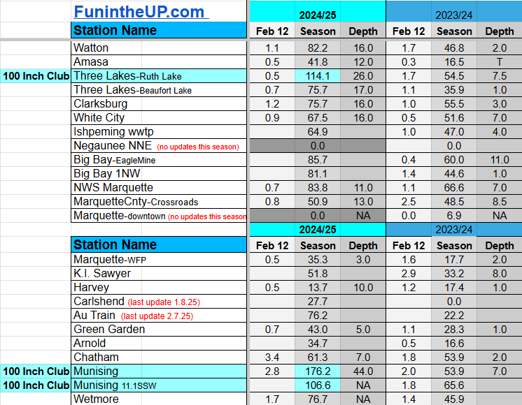
Today two locations joined the 200 Inch Club, making that 4 stations with 200+ inches of snow for the season as of this morning’s snow measurements. Last season (2023/24) we didn’t have a single station reach 200 inches of snow, the highest was Calumet/Tamarack with 173 inches. We should see at least 10 locations reach 200 inches this season and possibly 20 if the rest of February is pretty snowy and we see some decent snowfall in the months of March and April.
Hitting 300 inches of snow is still highly possible with the stations that are at 200+ inches as of today and slightly possible with another 4 stations that are within 40 inches of 200 as of today. In 2022/23 we had 13 locations in the 300 Inch Club.
We are now entering the coldest part of the year and with Lake Superior ice cover only at 23% it looks like we will see some good lake effect snow storms in Feb and early March.
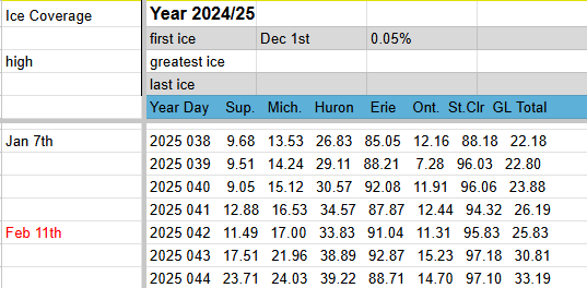
Snowfall overnight will be in the West snowbelts of the Keweenaw, other places across the UP will once again be left out of the snowfall.
Heading into Friday evening however things will change as wind direction switches to a south wind which will bring some warmer temps and snowfall to most of the U.P. Friday night into Saturday morning.
Temperatures will dip into the -20s in the western and central areas of the Upper Peninsula overnight and winds will be light and mostly calm so wind chills should be an issue. By late Friday morning and early afternoon we should see a swing back into the mid teens and low 20s as warmer air enters the U.P from the south along with some light snow. Snowfall amounts should generally be in the 1-4 inch range. After the slight warmup Friday afternoon and Saturday we will see temps slide back down into the single digits and possible negative single digits by Monday morning and winds will shift back into the NW which should allow more lake effect snow to return Monday into Tuesday.
Paid subscriptions on Substack allow these snowfall reports and fall color reports to continue each year. Thanks for subscribing to the Yooper Report become a subscriber to get snow totals and snowfall report/forecast emailed to you before they post here on the website.
Check out the FunintheUP Amazon Store - my recommended camping gear, winter clothing, Yooper rock hunting stuff, U.P. books worth reading
Join me on a Guided U.P. Tour to see places you’d never see on your own - UpperPeninsulaTours.com - adventures away from the crowds
Most snowfall Feb 12: Calumet/Tamarack loc with 5.1 inches
Most snowfall, season to date: Painesdale with 219.8 inches
Biggest 24hr total this season: Keweenaw county with 18 inches (2.9.25)
If daily slot is 0" the station hasn't updated or recorded no snowfall.
Sometimes a station won't update that day and does the next day.
Tahquamenon Falls State Park only updates at the end of each month.
Keweenaw county and Houghton County Airport only update during the weekdays.
Sanderson Field Airport (Soo) updates next day.
Feb 12
NOTE: Hover cursor over images to enlarge snowfall totals.


Do you enjoy FunintheUP videos and seeing the Snowfall Totals all winter? Consider supporting FunintheUP via PayPal - via Venmo
Thanks for following the U.P. Snow Totals page on FunintheUP.com
FunintheUP Youtube channel TourDaYoop Youtube channel FunintheUP on TikTok Yooper Steve on Facebook
Yooper Steve on Instagram
FunintheUP on Instagram
Snowfall on Feb 11, 2025
Snowfall Reports by Yooper Steve
Daily UP Snowfall for 2024/25
Today's Notes:
This post first posted on the Yooper Report - FunintheUP Substack, it is an email newsletter that is sent out to subscribers.
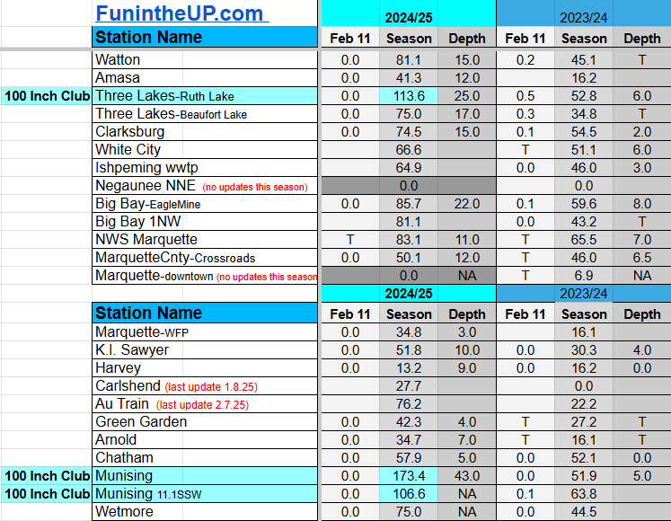
Snow Totals for Feb 11th below.
We have 4 stations in the 200 Inch Club those are Painesdale, Keweenaw county, Tamarack loc, and Houghton county stations.
Paid subscriptions on Substack allow these snowfall reports and fall color reports to continue each year. Thanks for subscribing to the Yooper Report become a subscriber to get snow totals and snowfall report/forecast emailed to you before they post here on the website.
Check out the FunintheUP Amazon Store - my recommended camping gear, winter clothing, Yooper rock hunting stuff, U.P. books worth reading
Join me on a Guided U.P. Tour to see places you’d never see on your own - UpperPeninsulaTours.com - adventures away from the crowds
Most snowfall Feb 11: Keweenaw county with 4 inches
Most snowfall, season to date: Painesdale with 217.4 inches
Biggest 24hr total this season: Keweenaw county with 18 inches (2.9.25)
If daily slot is 0" the station hasn't updated or recorded no snowfall.
Sometimes a station won't update that day and does the next day.
Tahquamenon Falls State Park only updates at the end of each month.
Keweenaw county and Houghton County Airport only update during the weekdays.
Sanderson Field Airport (Soo) updates next day.
Feb 11
NOTE: Hover cursor over images to enlarge snowfall totals.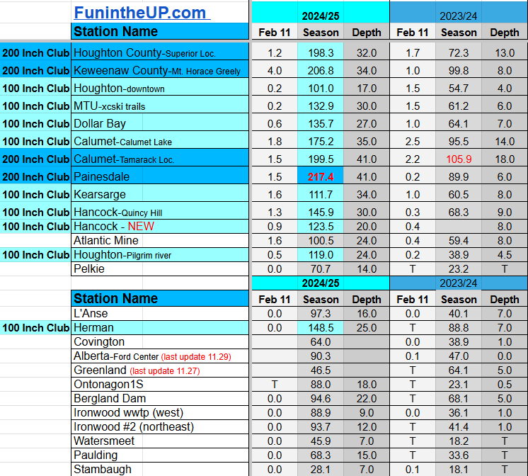


Do you enjoy FunintheUP videos and seeing the Snowfall Totals all winter? Consider supporting FunintheUP via PayPal - via Venmo
Thanks for following the U.P. Snow Totals page on FunintheUP.com
FunintheUP Youtube channel TourDaYoop Youtube channel FunintheUP on TikTok Yooper Steve on Facebook
Yooper Steve on Instagram
FunintheUP on Instagram
Snowfall on Feb 9/10, 2025
Snowfall Reports by Yooper Steve
Daily UP Snowfall for 2024/25
Today's Notes:
This post first posted on the Yooper Report - FunintheUP Substack, it is an email newsletter that is sent out to subscribers.
The Bayfield Bomber didn’t disappoint, I did dump a bit more snowfall than I had forecasted.
The Keweenaw finally saw a good snowstorm, not the biggest ever but the biggest this season for the Keweenaw. Isolated lake effect snow bands lingered around the Keweenaw in a stretch from Calumet to Delaware. Lake effect snow was enhanced by some convergent winds over the land along with the strong western winds over Lake Superior that kept snowfall in that region overnight dropping the biggest 24hr snow total of any location this season.
It was about mid afternoon on Monday when the convergent winds let up a bit and winds shifted slightly into a western to WNW pattern bringing a wider swath of snow banding further south from Twin Lakes to Painesdale, even areas along the Portage Canal got in a bit more snowfall as well.
Besides the Keweenaw the only other areas to see any significant snowfall was the Soo and Munising area, other areas got left out.
Late Wednesday night we should see a little warmer air move up into the region which could lead to some lake effect snow by Thursday behind it. Temps should get into the low teens to mid teens along Lake Superior.
Snowfall should be pretty minimal with 2-4 inches in the NW snowbelts and a trace to 2 inches across non NW snowbelts.
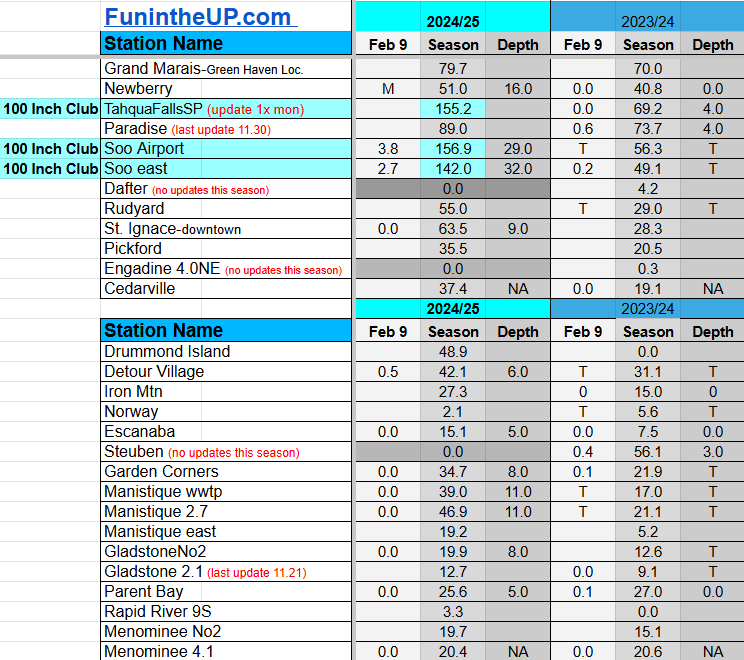
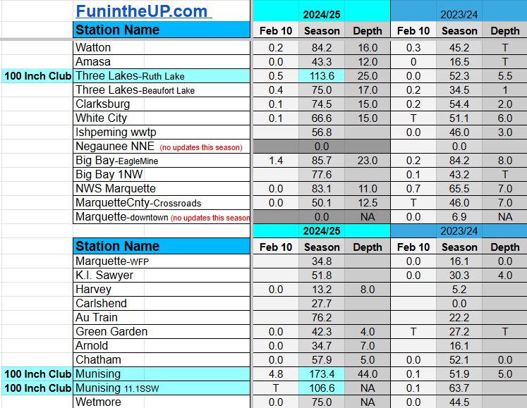
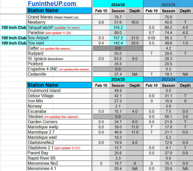
Snow Totals for Feb 9th and 10th below.
We have 2 stations now in the 200 Inch Club those are Painesdale and now Keweenaw county station that reached that milestone with an 18” snow fall Sunday night. Two day snow total for KC is 26”. Next stations that will reach 200 inches will be Houghton county and Calumet/Tamarack, both are less than 3 inches away. Not sure if they will reach that tomorrow, but they should by the weekend.
Paid subscriptions on Substack allow these snowfall reports and fall color reports to continue each year. Thanks for subscribing to the Yooper Report become a subscriber to get snow totals and snowfall report/forecast emailed to you before they post here on the website.
Check out the FunintheUP Amazon Store - my recommended camping gear, winter clothing, Yooper rock hunting stuff, U.P. books worth reading
Join me on a Guided U.P. Tour to see places you’d never see on your own - UpperPeninsulaTours.com - adventures away from the crowds
Most snowfall Feb 9: Keweenaw county with 18 inches
Most snowfall, season to date: Painesdale with 206.2 inches
Biggest 24hr total this season: Keweenaw county with 18 inches (2.9.25)
Most snowfall Feb 10: Calumet/Tamarack loc with 10.1 inches
Most snowfall, season to date: Painesdale with 215.9 inches
Biggest 24hr total this season: Keweenaw county with 18 inches (2.9.25)
If daily slot is 0" the station hasn't updated or recorded no snowfall.
Sometimes a station won't update that day and does the next day.
Tahquamenon Falls State Park only updates at the end of each month.
Keweenaw county and Houghton County Airport only update during the weekdays.
Sanderson Field Airport (Soo) updates next day.
Feb 9
NOTE: Hover cursor over images to enlarge snowfall totals.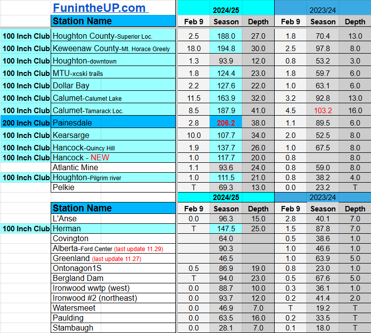


Feb 10
NOTE: Hover cursor over images to enlarge snowfall totals.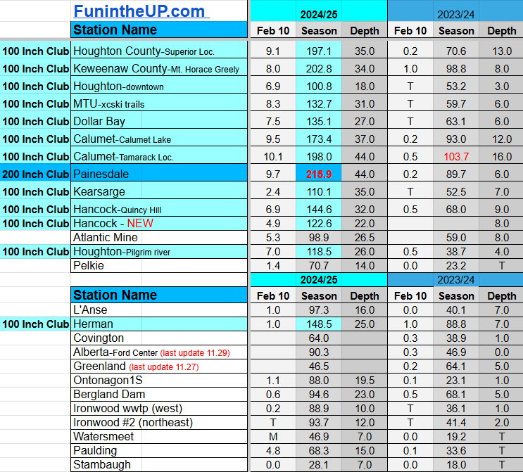

Do you enjoy FunintheUP videos and seeing the Snowfall Totals all winter? Consider supporting FunintheUP via PayPal - via Venmo
Thanks for following the U.P. Snow Totals page on FunintheUP.com
FunintheUP Youtube channel TourDaYoop Youtube channel FunintheUP on TikTok Yooper Steve on Facebook
Yooper Steve on Instagram
FunintheUP on Instagram
Snowfall on Feb 7, 2025
Snowfall Reports by Yooper Steve
Daily UP Snowfall for 2024/25
Today's Notes:
This post first posted on the Yooper Report - FunintheUP Substack, it is an email newsletter that is sent out to subscribers.
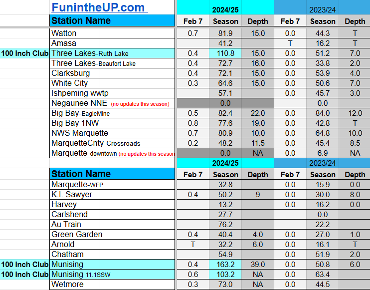
A little light snow blanketed the Upper Peninsula so there wasn’t a lot of snow to measure today. We did however get our first station into the 200 Inch Club with a few more coming soon within the next couple weeks, possibly sooner.
We are looking at a Bayfield Bomber moving into the Upper Peninsula Sunday bringing with it lake effect snowfall for northern Ontonagon county, northern Houghton, and the spine of Keweenaw county into Tuesday. Sunday night winds shift from WNW to a mainly west winds which will limit most of the snowfall to areas north of Hancock, Calumet, Ahmeek, Mohawk, and Central. Areas along the lake like Eagle River, Eagle Harbor, and Copper Harbor should probably see more snowfall than usual with N/NW winds. We could also see some convergent winds off the land in combination with the upper elevation topography enhancing snowfall amounts from Calumet to Central.
Other areas of the Upper Peninsula won’t see much snowfall until later in the week, but there will be a little snowfall in places like Munising and the Soo with the NW winds that will be blowing
Sunday morning and ending early evening.
The Soo should see very localized snowfall with a westerly wind so I’ll include that in the snow totals below through Tuesday.
Sunday snow totals
north Ontonagon county - northern Houghton county - Keweenaw 2-4”
Munising area - 1-2”
Soo - 0.5-1”
Monday-Tuesday afternoon snow totals
Northern Houghton county and Keweenaw 4-8”
Munising area - 0.5”
Soo - 2-4”
Temperatures will remain cold into the weekend and we could see some negative single digits in the western UP and parts of the central UP on Thursday and Friday. Friday with some south wind we could see a little lake enhanced snowfall off of Lake Michigan in areas near Manistique to St. Ignace. Not sure on snow totals right now, by mid week should have an idea if this will pan out.
A few things to note about the snowfall data.
You’ll notice that the numbers for McMillan have changed, I have adjusted the total because they snow observer there had issues with submitting the data and it has to be checked and verified for quality as it was a multiday total.
You’ll also notice that Tahquamenon falls snow total has been submitted and updated now, their data comes in monthly, wish it was more often but that’s how things have been done their at the state park for awhile, maybe I can see if I can get the data more often before it’s submitted to the database.
There are a dozen or so stations that don’t always update daily so the data might change suddenly from their last update to the current totals. Most station observers are good at getting their snow totals submitted daily.
I also do some QA checks on my end too, to ensure that the data I have is accurate, once in awhile I don’t always catch the updates or something goes awry on my end.
Paid subscriptions on Substack allow these snowfall reports and fall color reports to continue each year. Thanks for subscribing to the Yooper Report become a subscriber to get snow totals and snowfall report/forecast emailed to you before they post here on the website.
Check out the FunintheUP Amazon Store - my recommended camping gear, winter clothing, Yooper rock hunting stuff, U.P. books worth reading
Join me on a Guided U.P. Tour to see places you’d never see on your own - UpperPeninsulaTours.com - adventures away from the crowds
Most snowfall Feb 7: Soo airport with 3.6 inches
Most snowfall, season to date: Painesdale with 200.7 inches
Biggest 24hr total this season: Soo Airport with 15.7 inches (11.30.24)
If daily slot is 0" the station hasn't updated or recorded no snowfall.
Sometimes a station won't update that day and does the next day.
Tahquamenon Falls State Park only updates at the end of each month.
Keweenaw county and Houghton County Airport only update during the weekdays.
Sanderson Field Airport (Soo) updates next day.
Feb 7
NOTE: Hover cursor over images to enlarge snowfall totals.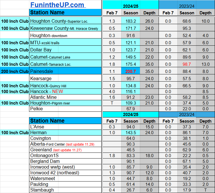


Do you enjoy FunintheUP videos and seeing the Snowfall Totals all winter? Consider supporting FunintheUP via PayPal - via Venmo
Thanks for following the U.P. Snow Totals page on FunintheUP.com
FunintheUP Youtube channel TourDaYoop Youtube channel FunintheUP on TikTok Yooper Steve on Facebook
Yooper Steve on Instagram
FunintheUP on Instagram
Snowfall on Feb 5/6, 2025
Snowfall Reports by Yooper Steve
Daily UP Snowfall for 2024/25
Today's Notes:
This post first posted on the Yooper Report - FunintheUP Substack, it is an email newsletter that is sent out to subscribers.
Well the Upper Peninsula survived the blizzard, it arrived pretty much on schedule from the forecast with winds gusts up to 58mph recorded at the Houghton county airport.
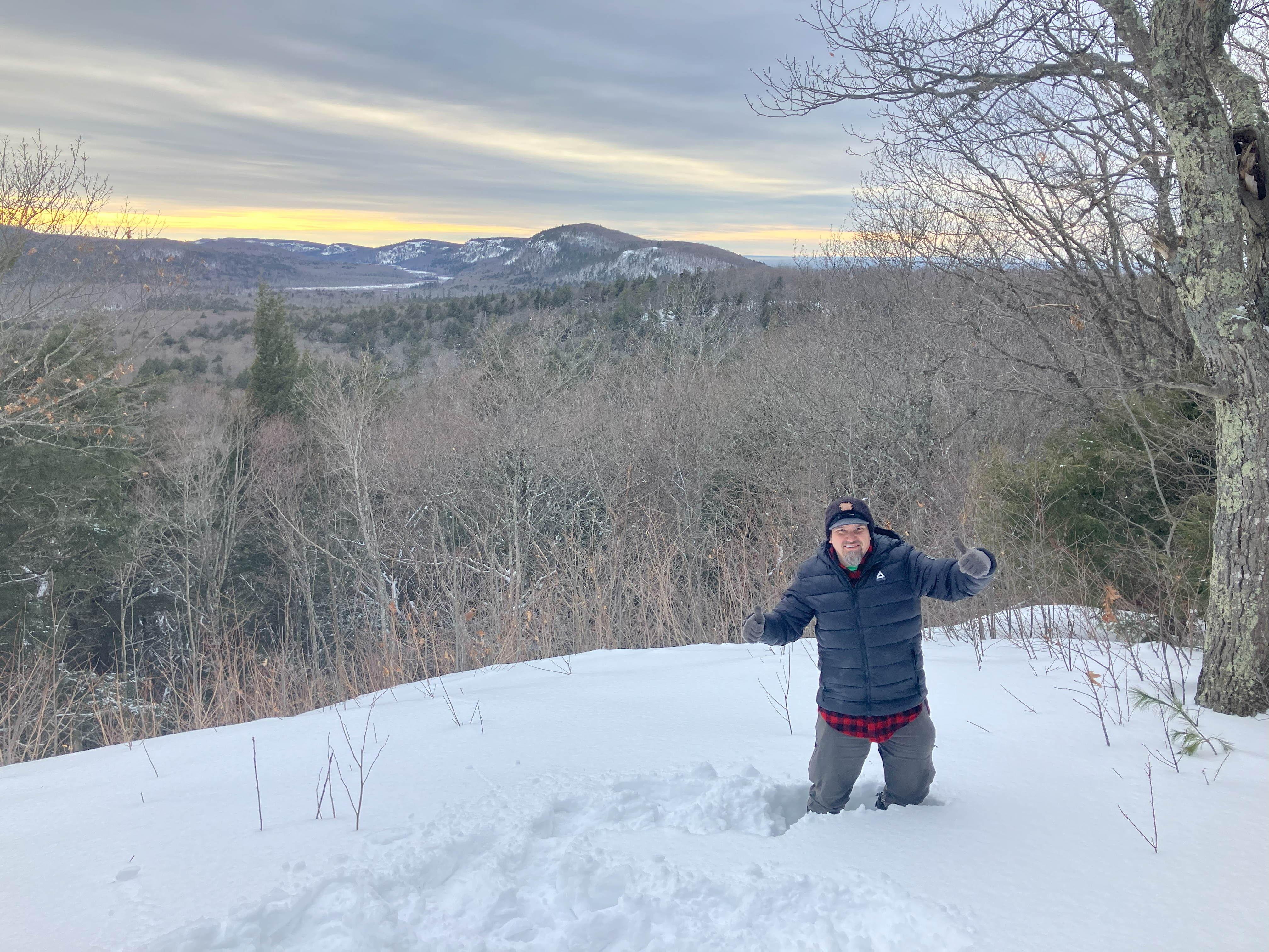
I was camping in Porcupine Mountains State park Wednesday night and woke up Thursday to high winds and snow blowing violently through the forest, tree tops flopping around and tree branches snapping.
Driving on the roads was pretty hazardous, the Michigan State Police reported a lot of vehicles in the ditch along US41 from Hancock to Calumet and suggested taking an alternate route. Reports on social media accounts from friends and in groups verified how terrified they were driving that stretch through the afternoon on Thursday and into the evening hours.
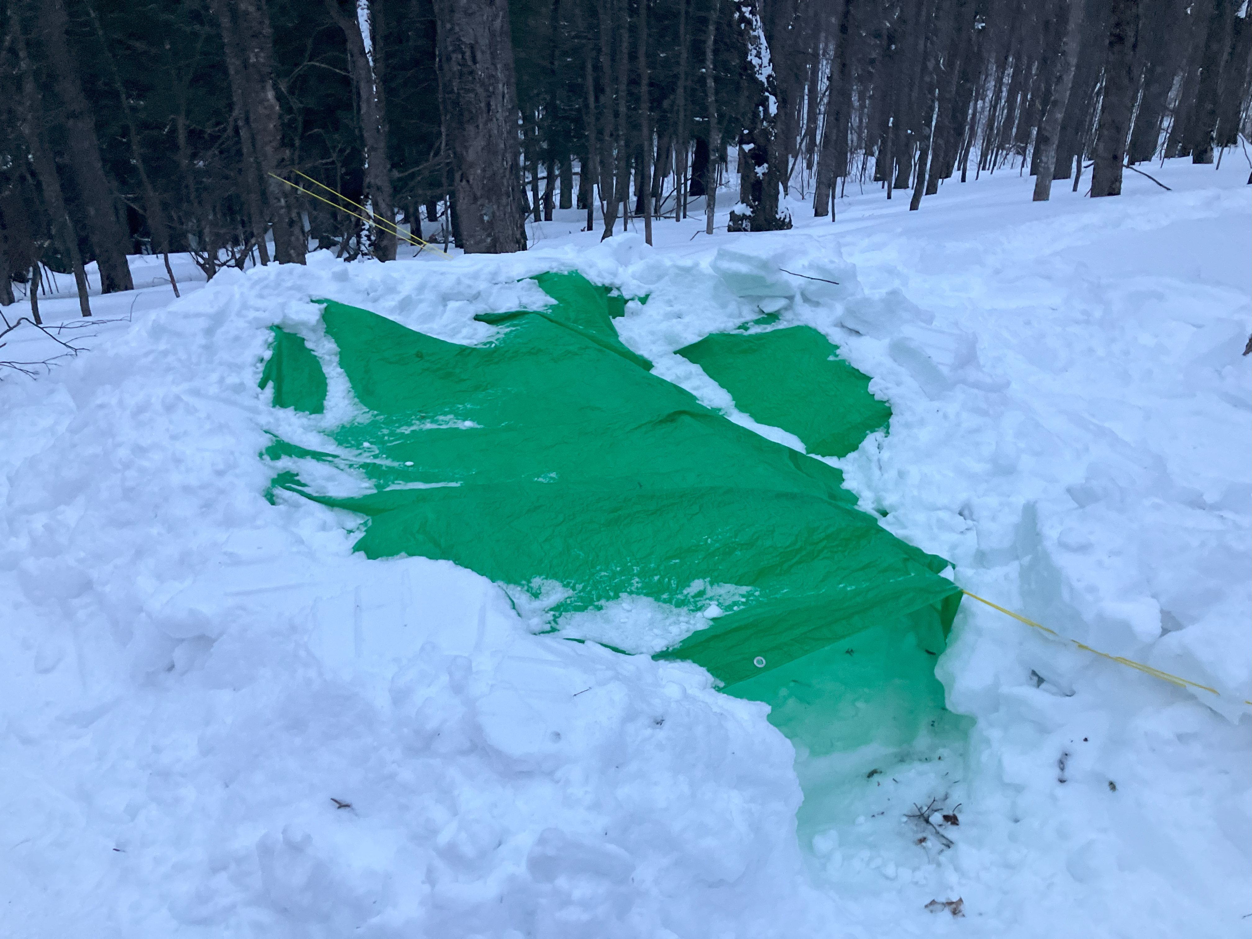
After packing up camping gear late morning and snowshoeing with pulk sled I went over to the East Vista from the West Vista where I was winter camping. From that viewpoint you could see the wall of snow moving across Silver City and Ontonagon, snow bands were intense to say the least.
I knew my drive back to Houghton was going to be interesting, but I’ve driven many dozens of winter whiteouts. I just knew I better get moving before it gets dark, my goal was to get back to the Porcupine ski hill parking lot where my Explorer was around 430pm, that would give me enough time to get back to Houghton around dark.
The next couple days we should see some light snow across most of the Upper Peninsula and the cold temps stick around for awhile.
Paid subscriptions on Substack allow these snowfall reports and fall color reports to continue each year. Thanks for subscribing to the Yooper Report become a subscriber to get snow totals and snowfall report/forecast emailed to you before they post here on the website.
Check out the FunintheUP Amazon Store - my recommended camping gear, winter clothing, Yooper rock hunting stuff, U.P. books worth reading
Join me on a Guided U.P. Tour to see places you’d never see on your own - UpperPeninsulaTours.com - adventures away from the crowds
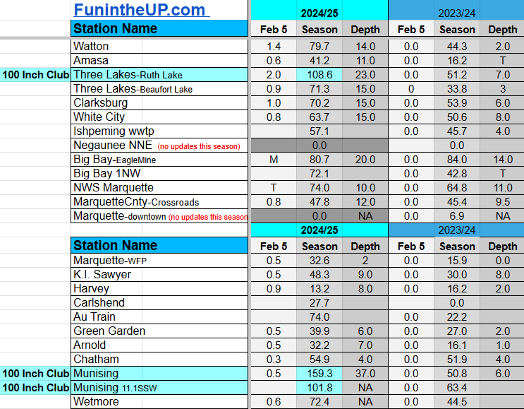
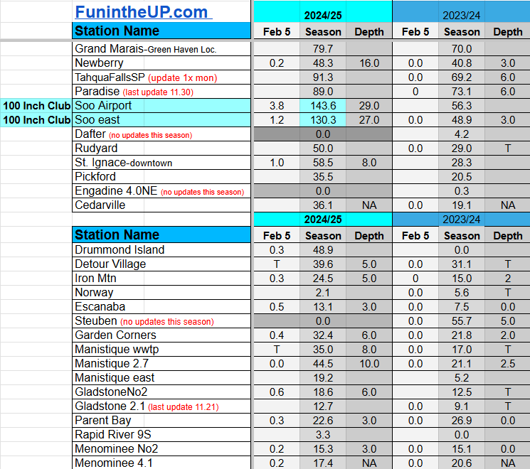
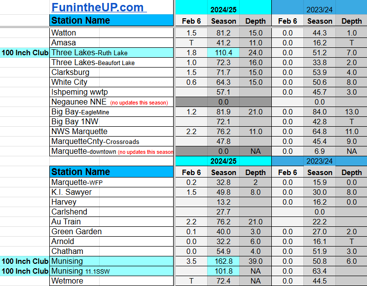
Most snowfall Feb 5: Soo airport with 3.8 inches
Most snowfall, season to date: Painesdale with 197.6 inches
Biggest 24hr total this season: Soo Airport with 15.7 inches (11.30.24)
Most snowfall Feb 6: Soo east with 6.6 inches
Most snowfall, season to date: Painesdale with 199.6 inches
Biggest 24hr total this season: Soo Airport with 15.7 inches (11.30.24)
If daily slot is 0" the station hasn't updated or recorded no snowfall.
Sometimes a station won't update that day and does the next day.
Tahquamenon Falls State Park only updates at the end of each month.
Keweenaw county and Houghton County Airport only update during the weekdays.
Sanderson Field Airport (Soo) updates next day.
Feb 5
NOTE: Hover cursor over images to enlarge snowfall totals.

Feb 6
NOTE: Hover cursor over images to enlarge snowfall totals.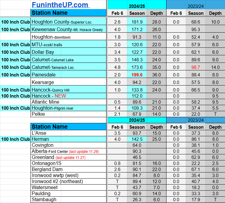


Do you enjoy FunintheUP videos and seeing the Snowfall Totals all winter? Consider supporting FunintheUP via PayPal - via Venmo
Thanks for following the U.P. Snow Totals page on FunintheUP.com
FunintheUP Youtube channel TourDaYoop Youtube channel FunintheUP on TikTok Yooper Steve on Facebook
Yooper Steve on Instagram
FunintheUP on Instagram
Snowfall on Feb 3, 2025
Snowfall Reports by Yooper Steve
Daily UP Snowfall for 2024/25
Today's Notes:
This post first posted on the Yooper Report - FunintheUP Substack, it is an email newsletter that is sent out to subscribers.
Just posting the snow totals for tonight. No forecast write up just that we will be seeing a few flurries Wednesday into Thursday morning maybe 2-6 with your higher elevations getting more in the NW snowbelts.
Should my vehicle cooperate I am heading out in the morning for a winter camping trip. Before I head out I have to measure my 6 snowfall stations (should we get any snow) tomorrow. I still have to get some stuff packed tomorrow before heading out as well. It should be a fun adventure, hopefully I’ll have some footage and pictures to share with you on a substack post or a youtube video.
Paid subscriptions on Substack allow these snowfall reports and fall color reports to continue each year. Thanks for subscribing to the Yooper Report become a subscriber to get snow totals and snowfall report/forecast emailed to you before they post here on the website.
Check out the FunintheUP Amazon Store - my recommended camping gear, winter clothing, Yooper rock hunting stuff, U.P. books worth reading
Join me on a Guided U.P. Tour to see places you’d never see on your own - UpperPeninsulaTours.com - adventures away from the crowds
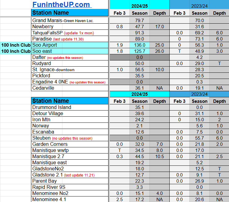
Most snowfall Feb 3: Keweenaw County with 4 inches
Most snowfall, season to date: Painesdale with 194.7 inches
Biggest 24hr total this season: Soo Airport with 15.7 inches (11.30.24)
If daily slot is 0" the station hasn't updated or recorded no snowfall.
Sometimes a station won't update that day and does the next day.
Tahquamenon Falls State Park only updates at the end of each month.
Keweenaw county and Houghton County Airport only update during the weekdays.
Sanderson Field Airport (Soo) updates next day.
Feb 3
NOTE: Hover cursor over images to enlarge snowfall totals.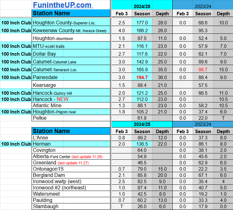


Do you enjoy FunintheUP videos and seeing the Snowfall Totals all winter? Consider supporting FunintheUP via PayPal - via Venmo
Thanks for following the U.P. Snow Totals page on FunintheUP.com
FunintheUP Youtube channel TourDaYoop Youtube channel FunintheUP on TikTok Yooper Steve on Facebook
Yooper Steve on Instagram
FunintheUP on Instagram
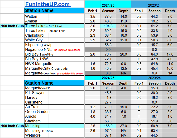
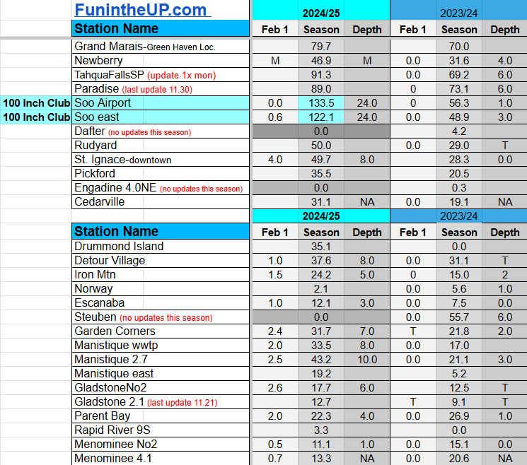
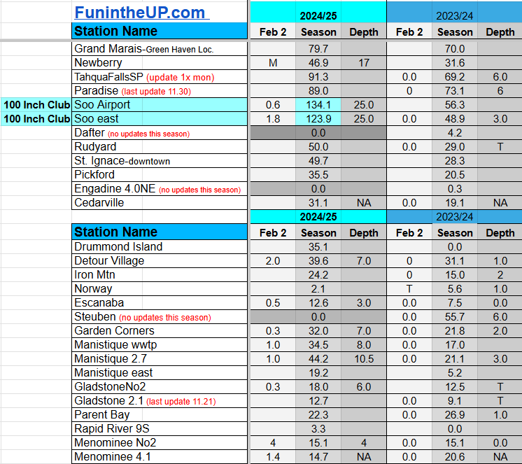
Snowfall on Feb 1/2, 2025
Snowfall Reports by Yooper Steve
Daily UP Snowfall for 2024/25
Today's Notes:
This post first posted on the Yooper Report - FunintheUP Substack, it is an email newsletter that is sent out to subscribers.
Not a lot of snow over the last few days but most areas across the U.P. have seen at least 1-5 inches. The Garden Peninsula to St. Ignace has finally saw a few inches of lake effect due to a SE wind off of Lake Michigan. Surprisingly even with the SE winds much of the U.P. saw snow from it I think it was from the warmer air aloft and strong winds that carried the light crystalline snow northward.
The next couple days we should see a few light flurries, as of tonight a couple inches has fallen in the NW snowbelts as wind picked up today from some cooler Arctic air moving in tonight bringing in about 1”/hr snow rates for a short period.
Temperatures have really dropped to from mid teens earlier today into the single digits and should stay that way throughout the day tomorrow across much of the Upper Peninsula. Expect a break in the snow flurries for most of Tuesday and into the early morning hours of Wed. We will see NW winds shifting into a westerly then into south winds Wednesday afternoon which should bring some warmer air into the region, temps should reach into the low to mid 20s before dropping back into the single digits late Thursday evening.
It appears with the gulf moisture coming into the lower Great Lakes that will hinder the amount of snowfall we see across the Upper Peninsula on Wednesday into Thursday morning. A bit of moisture coming across from the mountain west could bring in the moisture we need for some snow to develop, but again don’t expect a lot of out this system. Most probable areas to see more than 5 or 6 inches of snow would be Painesdale into the Keweenaw spine.
MTU Winter Carnival 2025
Stay tuned to the NWS Marquette website for updates if you are going to be traveling up to Houghton for Winter Carnival 2025, with the high winds and light snow it could get a little blustery out there on the roads Wednesday into Thursday.You will want to see the snow statues if you haven’t ever, the students at MTU do a great job every year and this year there is plenty of good snow and it has been cold for statue building. Check out the Winter Carnival website for happenings this week.
Paid subscriptions on Substack allow these snowfall reports and fall color reports to continue each year. Thanks for subscribing to the Yooper Report become a subscriber to get snow totals and snowfall report/forecast emailed to you before they post here on the website.
Check out the FunintheUP Amazon Store - my recommended camping gear, winter clothing, Yooper rock hunting stuff, U.P. books worth reading
Join me on a Guided U.P. Tour to see places you’d never see on your own - UpperPeninsulaTours.com - adventures away from the crowds
Most snowfall Feb 1: Houghton County with 5.3 inches
Most snowfall, season to date: Painesdale with 191.7 inches
Biggest 24hr total this season: Soo Airport with 15.7 inches (11.30.24)
Most snowfall Feb 2: Detour Village with 2 inches
Most snowfall, season to date: Painesdale with 191.7 inches
Biggest 24hr total this season: Soo Airport with 15.7 inches (11.30.24)
If daily slot is 0" the station hasn't updated or recorded no snowfall.
Sometimes a station won't update that day and does the next day.
Tahquamenon Falls State Park only updates at the end of each month.
Keweenaw county and Houghton County Airport only update during the weekdays.
Sanderson Field Airport (Soo) updates next day.
Feb 1
NOTE: Hover cursor over images to enlarge snowfall totals.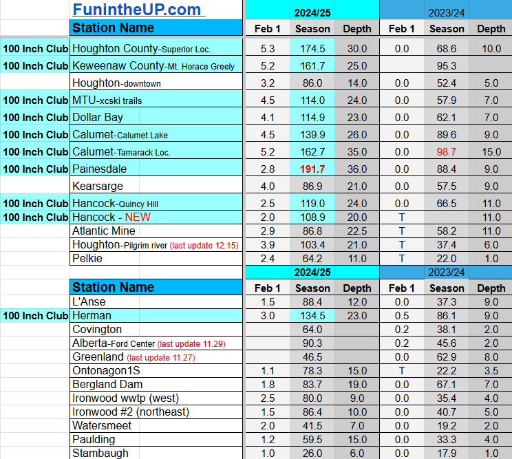

Feb 2
NOTE: Hover cursor over images to enlarge snowfall totals.


Do you enjoy FunintheUP videos and seeing the Snowfall Totals all winter? Consider supporting FunintheUP via PayPal - via Venmo
Thanks for following the U.P. Snow Totals page on FunintheUP.com
FunintheUP Youtube channel TourDaYoop Youtube channel FunintheUP on TikTok Yooper Steve on Facebook
Yooper Steve on Instagram
FunintheUP on Instagram
Previous Years Snowfall Totals
2023/2024 Upper Peninsula Snowfall2022/2023 Upper Peninsula Snowfall
2021/2022 Upper Peninsula Snowfall - 2019/2020 Upper Peninsula Snowfall - 2018/2019 Upper Peninsula Snowfall
2017/2018 Upper Peninsula Snowfall - 2016/2017 Upper Peninsula Snowfall - 2014/15 Upper Peninsula Snowfall
